Property Record
Military Highway 281, San Benito, TX 78586


This Property Is For Sale
NEARBY LISTINGS FOR SALE OR LEASE
-
-
View all San Benito listings for sale on LoopNet.com
Property Detail
Military Highway 281
Brownsville-Harlingen, TX
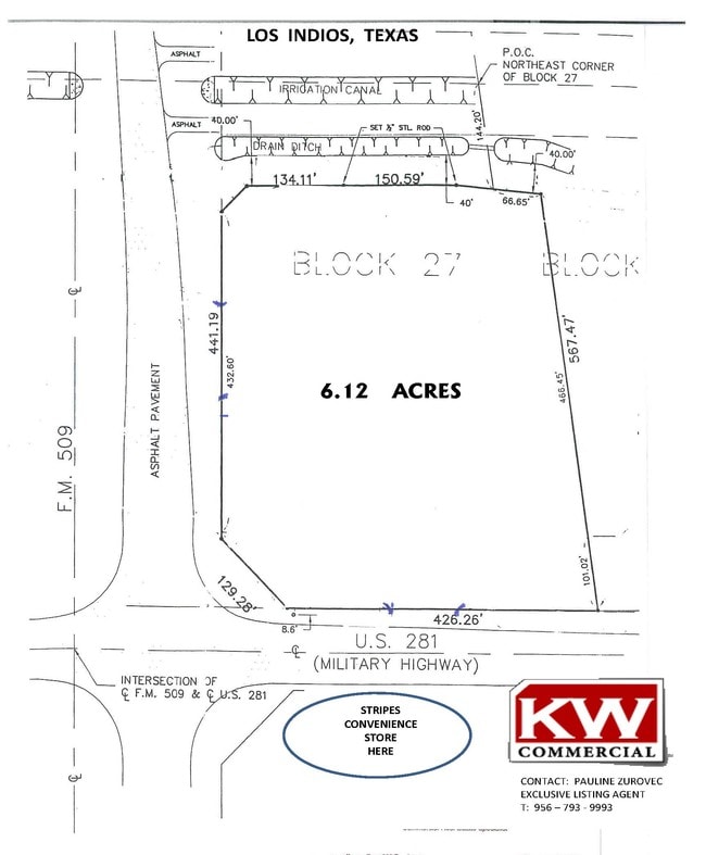
Los Indios Irrigated Land Co Subdivision
882310-0270-000000
ABST 16- LOS INDIOS A 6.120 ACS, BEING 4.726 ACS OUT OF BLK 27, .352 ACS OUT OF BLK 26 & 1.042 ACS OUT OF ABANDONED 100 FT RR-RIGHT-OF-WAY
Commercialacreage
Cameron
X
Texas
48061C0425F
6.12 AC
2024
Outlying Cameron County
2025
Brownsville/Harlingen
011601
DEMOGRAPHICS near Military Highway 281
1 Mile
3 Mile
5 Mile
2024 Total Population
111
1,546
6,380
2029 Population
107
1,515
6,432
Pop Growth 2024-2029
(3.60%)
(2.01%)
+ 0.82%
Average Age
38
37
35
2024 Total Households
31
422
1,686
HH Growth 2024-2029
(3.23%)
(2.13%)
+ 0.71%
Median Household Inc
$39,999
$43,863
$56,333
Avg Household Size
3.40
3.50
3.60
2024 Avg HH Vehicles
2.00
2.00
2.00
Median Home Value
$89,999
$86,214
$81,843
Median Year Built
1992
1993
1994
Nearby Places
Map Layers
Map Styles
 Street
 Aerial
- Restaurants
- Banks
- Shops
- Fitness
- Groceries
PUBLIC TRANSPORTATION
AIRPORT
Valley International
DRIVE
WALK
Distance
Valley International
23 min
14.1 mi
Brownsville/South Padre Island International
DRIVE
WALK
Distance
Brownsville/South Padre Island International
37 min
23.4 mi
Freight Ports
Port of Brownsville
DRIVE
WALK
Distance
Port of Brownsville
35 min
24.1 mi
Nearby Properties
Address
Land Use
TOTAL SIZE
Lot Size
Zoning
Address
Land Use
TOTAL SIZE
Lot Size
Zoning
189,048 SF
18.43 AC
Address
Land Use
TOTAL SIZE
Lot Size
Zoning
135,000 SF
9.79 AC
C
Address
Land Use
TOTAL SIZE
Lot Size
Zoning
105,785 SF
9 AC
I
Address
Land Use
TOTAL SIZE
Lot Size
Zoning
125,000 SF
256.81 AC
I
Address
Land Use
TOTAL SIZE
Lot Size
Zoning
90,420 SF
6.03 AC
Address
Land Use
TOTAL SIZE
Lot Size
Zoning
60,280 SF
3.70 AC
Address
Land Use
TOTAL SIZE
Lot Size
Zoning
50,250 SF
6.77 AC
Address
Land Use
TOTAL SIZE
Lot Size
Zoning
4,940 SF
2.30 AC
Address
Land Use
TOTAL SIZE
Lot Size
Zoning
381.24 AC
Address
Land Use
TOTAL SIZE
Lot Size
Zoning
12,085 SF
1 AC
Address
Land Use
TOTAL SIZE
Lot Size
Zoning
2,160 SF
18.45 AC
Address
Land Use
TOTAL SIZE
Lot Size
Zoning
10,148 SF
5.20 AC
A-R
Address
Land Use
TOTAL SIZE
Lot Size
Zoning
888 SF
20 AC
Address
Land Use
TOTAL SIZE
Lot Size
Zoning
9,100 SF
7.11 AC
C
Address
Land Use
TOTAL SIZE
Lot Size
Zoning
4,224 SF
3.05 AC
A-U
Address
Land Use
TOTAL SIZE
Lot Size
Zoning
42.81 AC
Address
Land Use
TOTAL SIZE
Lot Size
Zoning
1,440 SF
1.29 AC
A-C
Address
Land Use
TOTAL SIZE
Lot Size
Zoning
2,859 SF
0.45 AC
A-R
Address
Land Use
TOTAL SIZE
Lot Size
Zoning
1,176 SF
3.66 AC
A-R
Address
Land Use
TOTAL SIZE
Lot Size
Zoning
2,516 SF
3.13 AC
D
Address
Land Use
TOTAL SIZE
Lot Size
Zoning
752 SF
0.63 AC
Address
Land Use
TOTAL SIZE
Lot Size
Zoning
3,502 SF
6.86 AC
Address
Land Use
TOTAL SIZE
Lot Size
Zoning
16.05 AC
Address
Land Use
TOTAL SIZE
Lot Size
Zoning
2,870 SF
4.64 AC
Address
Land Use
TOTAL SIZE
Lot Size
Zoning
14.87 AC
Address
Land Use
TOTAL SIZE
Lot Size
Zoning
6,952 SF
3.64 AC
Address
Land Use
TOTAL SIZE
Lot Size
Zoning
14.51 AC
Address
Land Use
TOTAL SIZE
Lot Size
Zoning
5.50 AC
AC
Address
Land Use
TOTAL SIZE
Lot Size
Zoning
752 SF
11.95 AC
The World's #1 Commercial Real Estate Marketplace
Connect with us
© 2026 CoStar Group
The information above has been obtained from sources believed reliable. While we do not doubt its accuracy we have not verified it and make no guarantee, warranty or representation about it. It is your responsibility to independently confirm its accuracy and completeness. Any projections, opinions, assumptions, or estimates used are for example only and do not represent the current or future performance of the property. The value of this transaction to you depends on tax and other factors which should be evaluated by your tax, financial, and legal advisors. You and your advisors should conduct a careful, independent investigation of the property to determine to your satisfaction the suitability of the property for your needs.