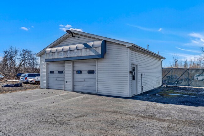
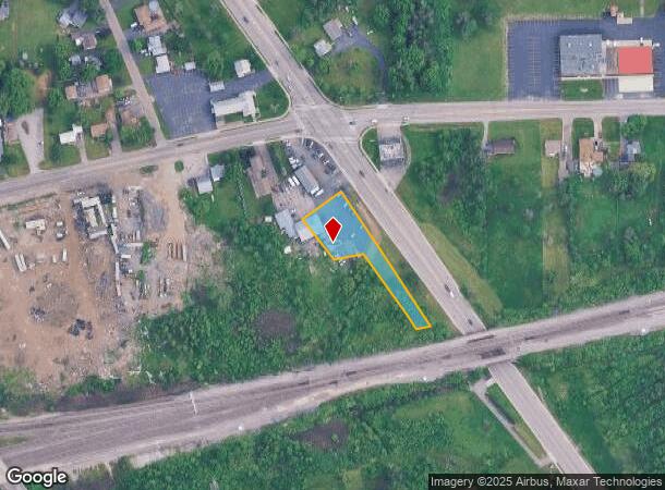
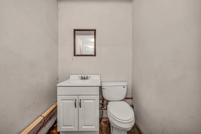
Property Record
Military Rd, Niagara Falls, NY 14305
NEARBY LISTINGS FOR SALE OR LEASE
Property Detail
Military Rd
Buffalo-Cheektowaga-Niagara Falls, NY
Niagara
293000-131-018-0004-004-021
New York
Servicestation
4.021
0
0.65 AC
2024
Niagara Falls
020200
Buffalo/Niagara Falls
900 SF
DEMOGRAPHICS near Military Rd
1 Mile
3 Mile
5 Mile
2024 Total Population
3,137
44,887
75,311
2029 Population
3,121
44,405
74,827
Pop Growth 2024-2029
(0.51%)
(1.07%)
(0.64%)
Average Age
44
40
42
2024 Total Households
1,297
19,124
33,223
HH Growth 2024-2029
(0.54%)
(1.19%)
(0.69%)
Median Household Inc
$68,561
$50,963
$53,937
Avg Household Size
2.30
2.20
2.10
2024 Avg HH Vehicles
2.00
1.00
1.00
Median Home Value
$185,247
$125,808
$157,824
Median Year Built
1962
1951
1953
Nearby Places
Map Layers
Map Styles
 Street
 Aerial
- Restaurants
- Banks
- Shops
- Fitness
- Groceries
PUBLIC TRANSPORTATION
COMMUTER RAIL
DRIVE
WALK
Distance
8 min
3.2 mi
DRIVE
WALK
Distance
8 min
3.5 mi
AIRPORT
Niagara Falls International
DRIVE
WALK
Distance
Niagara Falls International
9 min
3.7 mi
Buffalo Niagara International
DRIVE
WALK
Distance
Buffalo Niagara International
36 min
24.1 mi
Nearby Properties
Address
Land Use
TOTAL SIZE
Lot Size
Zoning
Address
Land Use
TOTAL SIZE
Lot Size
Zoning
28,080 SF
2,888.10 AC
Address
Land Use
TOTAL SIZE
Lot Size
Zoning
137,958 SF
1 AC
Address
Land Use
TOTAL SIZE
Lot Size
Zoning
34.59 AC
I2
Address
Land Use
TOTAL SIZE
Lot Size
Zoning
23,280 SF
163.20 AC
Address
Land Use
TOTAL SIZE
Lot Size
Zoning
22.40 AC
INS
Address
Land Use
TOTAL SIZE
Lot Size
Zoning
14.70 AC
I2
Address
Land Use
TOTAL SIZE
Lot Size
Zoning
95,628 SF
5.10 AC
C2-A
Address
Land Use
TOTAL SIZE
Lot Size
Zoning
86,660 SF
11.60 AC
I2
Address
Land Use
TOTAL SIZE
Lot Size
Zoning
441,749 SF
20.54 AC
I2
Address
Land Use
TOTAL SIZE
Lot Size
Zoning
375,735 SF
6.90 AC
OS
Address
Land Use
TOTAL SIZE
Lot Size
Zoning
0.89 AC
I2
Address
Land Use
TOTAL SIZE
Lot Size
Zoning
61.20 AC
02 - SINGL
Address
Land Use
TOTAL SIZE
Lot Size
Zoning
7.50 AC
05 - COMME
Address
Land Use
TOTAL SIZE
Lot Size
Zoning
410,860 SF
35.20 AC
05 - COMME
Address
Land Use
TOTAL SIZE
Lot Size
Zoning
18,829 SF
2.76 AC
OS
Address
Land Use
TOTAL SIZE
Lot Size
Zoning
64,006 SF
447.28 AC
OS
Address
Land Use
TOTAL SIZE
Lot Size
Zoning
167,976 SF
18.60 AC
Address
Land Use
TOTAL SIZE
Lot Size
Zoning
0.30 AC
R1-C
Address
Land Use
TOTAL SIZE
Lot Size
Zoning
160.52 AC
06 - INDUS
Address
Land Use
TOTAL SIZE
Lot Size
Zoning
36.90 AC
06 - INDUS
Address
Land Use
TOTAL SIZE
Lot Size
Zoning
240,000 SF
35.50 AC
05 - COMME
Address
Land Use
TOTAL SIZE
Lot Size
Zoning
35.80 AC
Address
Land Use
TOTAL SIZE
Lot Size
Zoning
247.60 AC
Address
Land Use
TOTAL SIZE
Lot Size
Zoning
59,474 SF
10.14 AC
06 - INDUS
Address
Land Use
TOTAL SIZE
Lot Size
Zoning
211,484 SF
18.30 AC
C3
Address
Land Use
TOTAL SIZE
Lot Size
Zoning
129,664 SF
5 AC
INS
Address
Land Use
TOTAL SIZE
Lot Size
Zoning
36,120 SF
83.58 AC
I1
Address
Land Use
TOTAL SIZE
Lot Size
Zoning
10,647 SF
14 AC
C3
Address
Land Use
TOTAL SIZE
Lot Size
Zoning
33.14 AC
C3
Address
Land Use
TOTAL SIZE
Lot Size
Zoning
123,682 SF
3.30 AC
The World's #1 Commercial Real Estate Marketplace
Connect with us
© 2025 CoStar Group
The information above has been obtained from sources believed reliable. While we do not doubt its accuracy we have not verified it and make no guarantee, warranty or representation about it. It is your responsibility to independently confirm its accuracy and completeness. Any projections, opinions, assumptions, or estimates used are for example only and do not represent the current or future performance of the property. The value of this transaction to you depends on tax and other factors which should be evaluated by your tax, financial, and legal advisors. You and your advisors should conduct a careful, independent investigation of the property to determine to your satisfaction the suitability of the property for your needs.