Property Record
Mill Ave, Brainerd, MN 56401
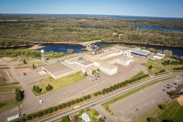

Property Detail
Mill Ave
Brainerd, MN
PT OF GL 1 & 2 SEC 19-45-30 DESC: BEG AT S1/4 COR OF SEC 18-45-30 & ASSM E LINE OF GL 4 OF SD SEC 18
050184203E00009
CROW WING
Parkinglot
Minnesota
B and X Area of moderate flood hazard, usually the area between the limits of the 100-year and 500-year floods.
1-5,3
2024
2.82 AC
2025
Minnesota Central Area
951200
Other Market Areas
92,032 SF
NEARBY LISTINGS FOR SALE OR LEASE
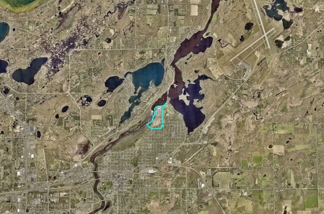
DEMOGRAPHICS near Mill Ave
1 mile
3 mile
5 mile
2024 Total Population
2,810
13,432
20,974
2029 Population
2,739
13,150
20,669
Pop Growth 2024-2029
(2.53%)
(2.10%)
(1.45%)
Average Age
40
40
40
2024 Total Households
1,138
5,565
8,630
HH Growth 2024-2029
(2.64%)
(2.32%)
(1.61%)
Median Household Inc
$60,319
$57,571
$61,521
Avg Household Size
2.40
2.20
2.30
2024 Avg HH Vehicles
2.00
2.00
2.00
Median Home Value
$208,190
$213,445
$257,925
Median Year Built
1971
1974
1981
Nearby Places
Map Layers
Map Styles
 Street
 Aerial
Transit
 Traffic
 Biking
Places
Listings with unknown addresses are not visible on the map
- Restaurants
- Banks
- Shops
- Fitness
- Groceries
SALE & LEASE HISTORY
LISTING DATE
SALE/LEASE

May 27, 2022
For Lease
Mar 10, 2023
For Lease
Jun 02, 2022
For Lease
Jul 02, 2019
For Lease
Dec 07, 2016
For Lease
Nearby Properties
Address
Land Use
TOTAL SIZE
Lot Size
Zoning
Address
Land Use
TOTAL SIZE
Lot Size
Zoning
320,708 SF
35.89 AC
Address
Land Use
TOTAL SIZE
Lot Size
Zoning
3,829 SF
1.04 AC
Address
Land Use
TOTAL SIZE
Lot Size
Zoning
186,000 SF
8.71 AC
Address
Land Use
TOTAL SIZE
Lot Size
Zoning
229,123 SF
11.84 AC
Address
Land Use
TOTAL SIZE
Lot Size
Zoning
31,074 SF
638.70 AC
Address
Land Use
TOTAL SIZE
Lot Size
Zoning
128,295 SF
2.08 AC
Address
Land Use
TOTAL SIZE
Lot Size
Zoning
110,624 SF
5.62 AC
Address
Land Use
TOTAL SIZE
Lot Size
Zoning
61,704 SF
16.09 AC
Address
Land Use
TOTAL SIZE
Lot Size
Zoning
Address
Land Use
TOTAL SIZE
Lot Size
Zoning
25,104 SF
18.43 AC
Address
Land Use
TOTAL SIZE
Lot Size
Zoning
113,024 SF
2.96 AC
Address
Land Use
TOTAL SIZE
Lot Size
Zoning
83,078 SF
9.71 AC
Address
Land Use
TOTAL SIZE
Lot Size
Zoning
90,147 SF
12.93 AC
Address
Land Use
TOTAL SIZE
Lot Size
Zoning
54,164 SF
5.65 AC
Address
Land Use
TOTAL SIZE
Lot Size
Zoning
66,967 SF
2.95 AC
Address
Land Use
TOTAL SIZE
Lot Size
Zoning
68,564 SF
3.41 AC
Address
Land Use
TOTAL SIZE
Lot Size
Zoning
47,378 SF
1.56 AC
Address
Land Use
TOTAL SIZE
Lot Size
Zoning
844 SF
31.98 AC
Address
Land Use
TOTAL SIZE
Lot Size
Zoning
48,324 SF
3.63 AC
Address
Land Use
TOTAL SIZE
Lot Size
Zoning
68,643 SF
2.34 AC
Address
Land Use
TOTAL SIZE
Lot Size
Zoning
34,033 SF
9.81 AC
Address
Land Use
TOTAL SIZE
Lot Size
Zoning
100,000 SF
51.22 AC
Address
Land Use
TOTAL SIZE
Lot Size
Zoning
57,426 SF
2.61 AC
Address
Land Use
TOTAL SIZE
Lot Size
Zoning
16,392 SF
26.78 AC
Address
Land Use
TOTAL SIZE
Lot Size
Zoning
37,996 SF
6.32 AC
Address
Land Use
TOTAL SIZE
Lot Size
Zoning
480 SF
22.30 AC
Address
Land Use
TOTAL SIZE
Lot Size
Zoning
30,040 SF
2.75 AC
Address
Land Use
TOTAL SIZE
Lot Size
Zoning
33,876 SF
0.97 AC
Address
Land Use
TOTAL SIZE
Lot Size
Zoning
29,158 SF
12.87 AC
Address
Land Use
TOTAL SIZE
Lot Size
Zoning
10,872 SF
0.48 AC
The World's #1 Commercial Real Estate Marketplace
Connect with us
© 2026 CoStar Group
The information above has been obtained from sources believed reliable. While we do not doubt its accuracy we have not verified it and make no guarantee, warranty or representation about it. It is your responsibility to independently confirm its accuracy and completeness. Any projections, opinions, assumptions, or estimates used are for example only and do not represent the current or future performance of the property. The value of this transaction to you depends on tax and other factors which should be evaluated by your tax, financial, and legal advisors. You and your advisors should conduct a careful, independent investigation of the property to determine to your satisfaction the suitability of the property for your needs.