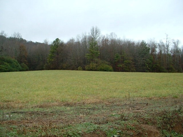
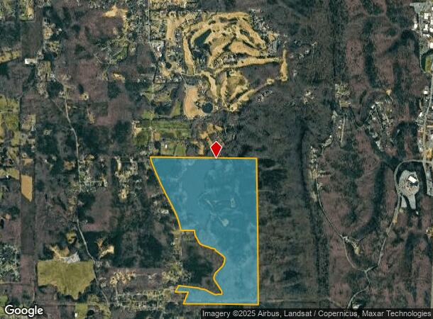
Property Record
Mill Crk, , GA
NEARBY LISTINGS FOR SALE OR LEASE
Property Detail
Mill Crk
Dalton, GA
Comm (By-Pass) 70K Ac
12-264-01-000
312.59A LL264 12
Commercialacreage
Whitfield
A
Georgia
13047C0175E
264
2024
312.59 AC
2024
Georgia Northwest
000700
Other Market Areas
DEMOGRAPHICS near Mill Crk
1 Mile
3 Mile
5 Mile
2024 Total Population
567
11,730
41,912
2029 Population
562
11,654
41,916
Pop Growth 2024-2029
(0.88%)
(0.65%)
+ 0.01%
Average Age
40
41
38
2024 Total Households
207
4,528
14,997
HH Growth 2024-2029
(0.97%)
(0.60%)
+ 0.03%
Median Household Inc
$85,613
$70,639
$60,314
Avg Household Size
2.70
2.50
2.70
2024 Avg HH Vehicles
2.00
2.00
2.00
Median Home Value
$218,902
$231,416
$197,368
Median Year Built
1989
1979
1981
Nearby Places
- Restaurants
- Banks
- Shops
- Fitness
- Groceries
PUBLIC TRANSPORTATION
AIRPORT
Lovell Field
DRIVE
WALK
Distance
Lovell Field
44 min
26.2 mi
Freight Ports
Georgia Ports - Savannah
DRIVE
WALK
Distance
Georgia Ports - Savannah
389 min
342.2 mi
Nearby Properties
Address
Land Use
TOTAL SIZE
Lot Size
Zoning
Address
Land Use
TOTAL SIZE
Lot Size
Zoning
54,546 SF
128.30 AC
Address
Land Use
TOTAL SIZE
Lot Size
Zoning
123,430 SF
51.17 AC
Address
Land Use
TOTAL SIZE
Lot Size
Zoning
115,979 SF
10.60 AC
C2
Address
Land Use
TOTAL SIZE
Lot Size
Zoning
150,771 SF
12.66 AC
Address
Land Use
TOTAL SIZE
Lot Size
Zoning
158,128 SF
13.71 AC
Address
Land Use
TOTAL SIZE
Lot Size
Zoning
8,208 SF
11.86 AC
Address
Land Use
TOTAL SIZE
Lot Size
Zoning
31,376 SF
9.64 AC
Address
Land Use
TOTAL SIZE
Lot Size
Zoning
185,916 SF
24.52 AC
Address
Land Use
TOTAL SIZE
Lot Size
Zoning
92,416 SF
9.80 AC
R-7
Address
Land Use
TOTAL SIZE
Lot Size
Zoning
97,788 SF
2.76 AC
Address
Land Use
TOTAL SIZE
Lot Size
Zoning
110,044 SF
8.45 AC
Address
Land Use
TOTAL SIZE
Lot Size
Zoning
99,486 SF
8.66 AC
MU
Address
Land Use
TOTAL SIZE
Lot Size
Zoning
62,052 SF
6.67 AC
Address
Land Use
TOTAL SIZE
Lot Size
Zoning
46,086 SF
9.16 AC
Address
Land Use
TOTAL SIZE
Lot Size
Zoning
79,057 SF
26.16 AC
Address
Land Use
TOTAL SIZE
Lot Size
Zoning
54,076 SF
2.20 AC
Address
Land Use
TOTAL SIZE
Lot Size
Zoning
88,288 SF
15 AC
Address
Land Use
TOTAL SIZE
Lot Size
Zoning
63,687 SF
2.01 AC
Address
Land Use
TOTAL SIZE
Lot Size
Zoning
34,428 SF
10.10 AC
R-7
Address
Land Use
TOTAL SIZE
Lot Size
Zoning
61,404 SF
11.92 AC
R7
Address
Land Use
TOTAL SIZE
Lot Size
Zoning
85,272 SF
2.15 AC
Address
Land Use
TOTAL SIZE
Lot Size
Zoning
61,830 SF
5.23 AC
Address
Land Use
TOTAL SIZE
Lot Size
Zoning
26,250 SF
4.42 AC
Address
Land Use
TOTAL SIZE
Lot Size
Zoning
103,300 SF
12.50 AC
Address
Land Use
TOTAL SIZE
Lot Size
Zoning
58,695 SF
2.15 AC
Address
Land Use
TOTAL SIZE
Lot Size
Zoning
58,050 SF
30.05 AC
Address
Land Use
TOTAL SIZE
Lot Size
Zoning
53,667 SF
4.89 AC
Address
Land Use
TOTAL SIZE
Lot Size
Zoning
21,208 SF
6.25 AC
Address
Land Use
TOTAL SIZE
Lot Size
Zoning
129,955 SF
9.59 AC
R-7
Address
Land Use
TOTAL SIZE
Lot Size
Zoning
25,532 SF
4.22 AC
The World's #1 Commercial Real Estate Marketplace
Connect with us
© 2025 CoStar Group
The information above has been obtained from sources believed reliable. While we do not doubt its accuracy we have not verified it and make no guarantee, warranty or representation about it. It is your responsibility to independently confirm its accuracy and completeness. Any projections, opinions, assumptions, or estimates used are for example only and do not represent the current or future performance of the property. The value of this transaction to you depends on tax and other factors which should be evaluated by your tax, financial, and legal advisors. You and your advisors should conduct a careful, independent investigation of the property to determine to your satisfaction the suitability of the property for your needs.