Property Record
Mill Rd, Coram, NY 11727
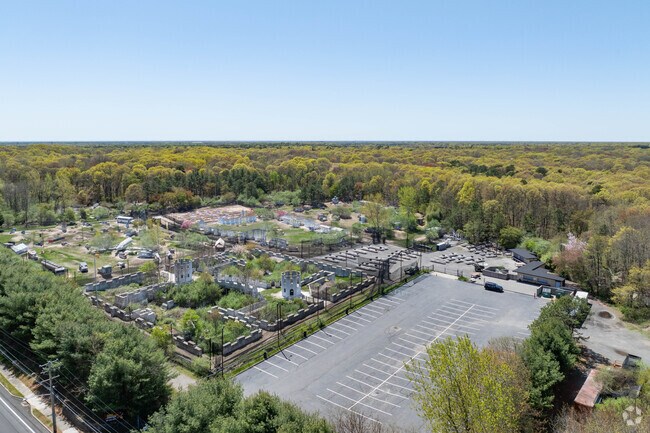

Property Detail
Mill Rd
Nassau County-Suffolk County, NY
N MARGRAF&CRM YP R E CRM YAP RD T13
0200-525-00-01-00-005-000
SUFFOLK
Recreationalentertainmentgeneral
New York
B and X Area of moderate flood hazard, usually the area between the limits of the 100-year and 500-year floods.
5
2024
12.97 AC
2024
Central Suffolk
158325
Long Island (New York)
NEARBY LISTINGS FOR SALE OR LEASE
DEMOGRAPHICS near Mill Rd
1 mile
3 mile
5 mile
2025 Total Population
5,299
60,289
166,258
2030 Population
5,277
59,919
165,400
Pop Growth 2025-2030
(0.42%)
(0.61%)
(0.52%)
Average Age
39
41
41
2025 Total Households
1,662
21,381
56,963
HH Growth 2025-2030
(0.90%)
(0.87%)
(0.74%)
Median Household Inc
$99,111
$103,860
$111,513
Avg Household Size
2.90
2.70
2.80
2025 Avg HH Vehicles
2.00
2.00
2.00
Median Home Value
$418,621
$444,049
$473,328
Median Year Built
1994
1977
1976
Nearby Places
Map Layers
Map Styles
 Street
 Aerial
Transit
 Traffic
 Biking
Places
Listings with unknown addresses are not visible on the map
- Restaurants
- Banks
- Shops
- Fitness
- Groceries
PUBLIC TRANSPORTATION
COMMUTER RAIL
Medford Station (Greenport Branch - Long Island Rail Road)
Drive
Walk
Distance
Medford Station (Greenport Branch - Long Island Rail Road)
9 min
3.7 mi
Yaphank Station (Greenport Branch - Long Island Rail Road)
Drive
Walk
Distance
Yaphank Station (Greenport Branch - Long Island Rail Road)
10 min
4.9 mi
AIRPORT
Long Island MacArthur
Drive
Walk
Distance
Long Island MacArthur
24 min
13.4 mi
Tweed/New Haven
Drive
Walk
Distance
Tweed/New Haven
129 min
48.2 mi
Nearby Properties
Address
Land Use
TOTAL SIZE
Lot Size
Zoning
Address
Land Use
TOTAL SIZE
Lot Size
Zoning
26,576 SF
2.30 AC
LI40
Address
Land Use
TOTAL SIZE
Lot Size
Zoning
21,554 SF
1.03 AC
HC
Address
Land Use
TOTAL SIZE
Lot Size
Zoning
3,879 SF
0.57 AC
R1
Address
Land Use
TOTAL SIZE
Lot Size
Zoning
5,530 SF
0.44 AC
R1
Address
Land Use
TOTAL SIZE
Lot Size
Zoning
Address
Land Use
TOTAL SIZE
Lot Size
Zoning
Address
Land Use
TOTAL SIZE
Lot Size
Zoning
31.33 AC
Address
Land Use
TOTAL SIZE
Lot Size
Zoning
71.41 AC
Address
Land Use
TOTAL SIZE
Lot Size
Zoning
47.20 AC
Address
Land Use
TOTAL SIZE
Lot Size
Zoning
12.47 AC
Address
Land Use
TOTAL SIZE
Lot Size
Zoning
0.53 AC
R20
Address
Land Use
TOTAL SIZE
Lot Size
Zoning
Address
Land Use
TOTAL SIZE
Lot Size
Zoning
38.42 AC
Address
Land Use
TOTAL SIZE
Lot Size
Zoning
27.75 AC
Address
Land Use
TOTAL SIZE
Lot Size
Zoning
Address
Land Use
TOTAL SIZE
Lot Size
Zoning
18.50 AC
Address
Land Use
TOTAL SIZE
Lot Size
Zoning
1,362 SF
0.39 AC
HC
Address
Land Use
TOTAL SIZE
Lot Size
Zoning
16.04 AC
Address
Land Use
TOTAL SIZE
Lot Size
Zoning
Address
Land Use
TOTAL SIZE
Lot Size
Zoning
22.45 AC
Address
Land Use
TOTAL SIZE
Lot Size
Zoning
23.35 AC
Address
Land Use
TOTAL SIZE
Lot Size
Zoning
27.55 AC
Address
Land Use
TOTAL SIZE
Lot Size
Zoning
16.50 AC
Address
Land Use
TOTAL SIZE
Lot Size
Zoning
Address
Land Use
TOTAL SIZE
Lot Size
Zoning
14.11 AC
Address
Land Use
TOTAL SIZE
Lot Size
Zoning
23.91 AC
Address
Land Use
TOTAL SIZE
Lot Size
Zoning
Address
Land Use
TOTAL SIZE
Lot Size
Zoning
25.30 AC
Address
Land Use
TOTAL SIZE
Lot Size
Zoning
Address
Land Use
TOTAL SIZE
Lot Size
Zoning
23.72 AC
The World's #1 Commercial Real Estate Marketplace
Connect with us
© 2026 CoStar Group
The information above has been obtained from sources believed reliable. While we do not doubt its accuracy we have not verified it and make no guarantee, warranty or representation about it. It is your responsibility to independently confirm its accuracy and completeness. Any projections, opinions, assumptions, or estimates used are for example only and do not represent the current or future performance of the property. The value of this transaction to you depends on tax and other factors which should be evaluated by your tax, financial, and legal advisors. You and your advisors should conduct a careful, independent investigation of the property to determine to your satisfaction the suitability of the property for your needs.