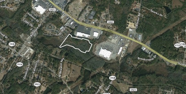
Property Record
Mill Rd, Hamlet, NC 28345

This Property Is For Sale
Property Detail
Mill Rd
Rockingham, NC
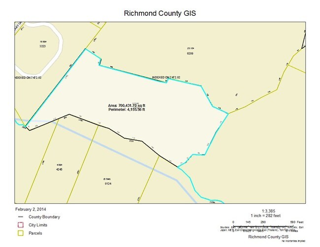
PARCEL A, REAR LAND
747204-74-0754
RICHMOND
Commercialnec
North Carolina
AE The base floodplain where base flood elevations are provided. AE Zones are now used on new format FIRMs instead of A1-A30 Zones.
16.04 AC
2025
North Carolina Southeast Area
2025
Other Market Areas
971000
NEARBY LISTINGS FOR SALE OR LEASE
DEMOGRAPHICS near Mill Rd
1 mile
3 mile
5 mile
2025 Total Population
2,652
18,552
29,908
2030 Population
2,608
18,417
29,612
Pop Growth 2025-2030
(1.66%)
(0.73%)
(0.99%)
Average Age
39
40
41
2025 Total Households
1,180
7,714
12,375
HH Growth 2025-2030
(1.95%)
(0.83%)
(1.07%)
Median Household Inc
$27,500
$37,679
$40,576
Avg Household Size
2.20
2.30
2.40
2025 Avg HH Vehicles
1.00
2.00
2.00
Median Home Value
$103,017
$129,653
$129,706
Median Year Built
1976
1972
1974
Nearby Places
Map Layers
Map Styles
 Street
 Aerial
Layers
 Traffic
 Biking
Places
Listings with unknown addresses are not visible on the map
- Restaurants
- Banks
- Shops
- Fitness
- Groceries
PUBLIC TRANSPORTATION
COMMUTER RAIL
Hamlet Amtrak Station (Silver Star - Amtrak)
Drive
Walk
Distance
Hamlet Amtrak Station (Silver Star - Amtrak)
7 min
3.9 mi
Freight Ports
Port of Wilmington
Drive
Walk
Distance
Port of Wilmington
156 min
126.6 mi
Nearby Properties
Address
Land Use
TOTAL SIZE
Lot Size
Zoning
Address
Land Use
TOTAL SIZE
Lot Size
Zoning
43.38 AC
HI
Address
Land Use
TOTAL SIZE
Lot Size
Zoning
187,379 SF
43.43 AC
Address
Land Use
TOTAL SIZE
Lot Size
Zoning
131,657 SF
18.83 AC
Address
Land Use
TOTAL SIZE
Lot Size
Zoning
5,120 SF
15.36 AC
Address
Land Use
TOTAL SIZE
Lot Size
Zoning
66,923 SF
26.15 AC
Address
Land Use
TOTAL SIZE
Lot Size
Zoning
11,435 SF
2.04 AC
Address
Land Use
TOTAL SIZE
Lot Size
Zoning
25,854 SF
12.76 AC
I2
Address
Land Use
TOTAL SIZE
Lot Size
Zoning
20,240 SF
2.85 AC
Address
Land Use
TOTAL SIZE
Lot Size
Zoning
13,057 SF
1.78 AC
Address
Land Use
TOTAL SIZE
Lot Size
Zoning
156,574 SF
27.74 AC
B3
Address
Land Use
TOTAL SIZE
Lot Size
Zoning
20,280 SF
5.49 AC
Address
Land Use
TOTAL SIZE
Lot Size
Zoning
32,284 SF
7.82 AC
B3
Address
Land Use
TOTAL SIZE
Lot Size
Zoning
7,260 SF
10.85 AC
Address
Land Use
TOTAL SIZE
Lot Size
Zoning
42,140 SF
5.69 AC
Address
Land Use
TOTAL SIZE
Lot Size
Zoning
17,086 SF
4.92 AC
Address
Land Use
TOTAL SIZE
Lot Size
Zoning
15,903 SF
1.25 AC
Address
Land Use
TOTAL SIZE
Lot Size
Zoning
5.03 AC
B3
Address
Land Use
TOTAL SIZE
Lot Size
Zoning
27,152 SF
8.21 AC
Address
Land Use
TOTAL SIZE
Lot Size
Zoning
Address
Land Use
TOTAL SIZE
Lot Size
Zoning
93,600 SF
7.47 AC
HI
Address
Land Use
TOTAL SIZE
Lot Size
Zoning
4,810 SF
9 AC
Address
Land Use
TOTAL SIZE
Lot Size
Zoning
62,360 SF
10.16 AC
Address
Land Use
TOTAL SIZE
Lot Size
Zoning
36,000 SF
10 AC
Address
Land Use
TOTAL SIZE
Lot Size
Zoning
11,572 SF
1.67 AC
Address
Land Use
TOTAL SIZE
Lot Size
Zoning
13,200 SF
7.59 AC
Address
Land Use
TOTAL SIZE
Lot Size
Zoning
17,061 SF
3.13 AC
R12
Address
Land Use
TOTAL SIZE
Lot Size
Zoning
7,566 SF
9.40 AC
Address
Land Use
TOTAL SIZE
Lot Size
Zoning
6,603 SF
2.45 AC
Address
Land Use
TOTAL SIZE
Lot Size
Zoning
4,940 SF
5.99 AC
Address
Land Use
TOTAL SIZE
Lot Size
Zoning
15,000 SF
2.49 AC
B3
The World's #1 Commercial Real Estate Marketplace
Connect with us
© 2026 CoStar Group
The information above has been obtained from sources believed reliable. While we do not doubt its accuracy we have not verified it and make no guarantee, warranty or representation about it. It is your responsibility to independently confirm its accuracy and completeness. Any projections, opinions, assumptions, or estimates used are for example only and do not represent the current or future performance of the property. The value of this transaction to you depends on tax and other factors which should be evaluated by your tax, financial, and legal advisors. You and your advisors should conduct a careful, independent investigation of the property to determine to your satisfaction the suitability of the property for your needs.