Property Record
Miller Rd, Henrico, VA 23231
NEARBY LISTINGS FOR SALE OR LEASE
Property Detail
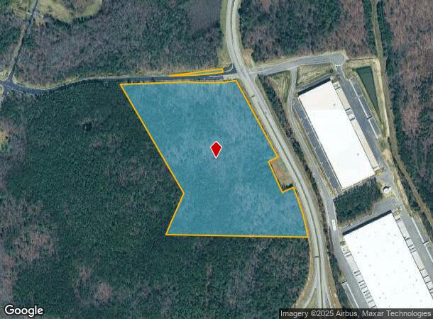
Miller Rd
Richmond, VA
AIRPORT DR AC 32.007
818-701-6273
Henrico
Industrialacreage
Virginia
2025
32.01 AC
2025
Airport
201502
Richmond VA
DEMOGRAPHICS near Miller Rd
1 Mile
3 Mile
5 Mile
2024 Total Population
433
18,829
70,890
2029 Population
432
18,802
71,355
Pop Growth 2024-2029
(0.23%)
(0.14%)
+ 0.66%
Average Age
44
40
40
2024 Total Households
169
7,271
28,974
HH Growth 2024-2029
0.00%
(0.19%)
+ 0.71%
Median Household Inc
$95,108
$76,831
$58,935
Avg Household Size
2.40
2.50
2.40
2024 Avg HH Vehicles
2.00
2.00
2.00
Median Home Value
$261,016
$235,125
$216,018
Median Year Built
1985
1990
1979
Nearby Places
Map Layers
Map Styles
 Street
 Aerial
- Restaurants
- Banks
- Shops
- Fitness
- Groceries
PUBLIC TRANSPORTATION
AIRPORT
Richmond International
DRIVE
WALK
Distance
Richmond International
17 min
9.6 mi
Freight Ports
Virginia Port Authority - Richmond
DRIVE
WALK
Distance
Virginia Port Authority - Richmond
23 min
14.1 mi
SALE & LEASE HISTORY
LISTING DATE
SALE/LEASE

Mar 29, 2024
For Lease
Nearby Properties
Address
Land Use
TOTAL SIZE
Lot Size
Zoning
Address
Land Use
TOTAL SIZE
Lot Size
Zoning
548,680 SF
2,298.89 AC
MIXE
Address
Land Use
TOTAL SIZE
Lot Size
Zoning
920,673 SF
99.01 AC
MIXE
Address
Land Use
TOTAL SIZE
Lot Size
Zoning
49,152 SF
31.21 AC
M-1
Address
Land Use
TOTAL SIZE
Lot Size
Zoning
15,894 SF
35.63 AC
A-1
Address
Land Use
TOTAL SIZE
Lot Size
Zoning
407,205 SF
286.12 AC
MIXE
Address
Land Use
TOTAL SIZE
Lot Size
Zoning
190,000 SF
16.65 AC
R-5C
Address
Land Use
TOTAL SIZE
Lot Size
Zoning
446,500 SF
49.33 AC
M1-C
Address
Land Use
TOTAL SIZE
Lot Size
Zoning
4,556 SF
8.76 AC
R-5C
Address
Land Use
TOTAL SIZE
Lot Size
Zoning
444,069 SF
23.82 AC
M-1
Address
Land Use
TOTAL SIZE
Lot Size
Zoning
162,289 SF
35 AC
A-1
Address
Land Use
TOTAL SIZE
Lot Size
Zoning
322,000 SF
15.94 AC
M-1
Address
Land Use
TOTAL SIZE
Lot Size
Zoning
278,967 SF
26.07 AC
M1-C
Address
Land Use
TOTAL SIZE
Lot Size
Zoning
146,560 SF
11.09 AC
R-5
Address
Land Use
TOTAL SIZE
Lot Size
Zoning
179,359 SF
11.85 AC
M-1
Address
Land Use
TOTAL SIZE
Lot Size
Zoning
246,760 SF
59.70 AC
M-2C
Address
Land Use
TOTAL SIZE
Lot Size
Zoning
108,738 SF
6.39 AC
R-6
Address
Land Use
TOTAL SIZE
Lot Size
Zoning
241,800 SF
M-2C
Address
Land Use
TOTAL SIZE
Lot Size
Zoning
27,670 SF
21.90 AC
A-1
Address
Land Use
TOTAL SIZE
Lot Size
Zoning
142,379 SF
17.69 AC
M-1
Address
Land Use
TOTAL SIZE
Lot Size
Zoning
76,208 SF
24.97 AC
B-3
Address
Land Use
TOTAL SIZE
Lot Size
Zoning
69,248 SF
5.24 AC
B-3C
Address
Land Use
TOTAL SIZE
Lot Size
Zoning
53,530 SF
4.50 AC
M-1C
Address
Land Use
TOTAL SIZE
Lot Size
Zoning
1,782 SF
400 AC
A-1
Address
Land Use
TOTAL SIZE
Lot Size
Zoning
202,560 SF
13.27 AC
M-1C
Address
Land Use
TOTAL SIZE
Lot Size
Zoning
316,548 SF
20.94 AC
M-1
Address
Land Use
TOTAL SIZE
Lot Size
Zoning
216,000 SF
17.08 AC
M-1C
Address
Land Use
TOTAL SIZE
Lot Size
Zoning
155,268 SF
11.50 AC
R-5
Address
Land Use
TOTAL SIZE
Lot Size
Zoning
168,520 SF
9.86 AC
M-1C
Address
Land Use
TOTAL SIZE
Lot Size
Zoning
83,644 SF
29.83 AC
A-1
Address
Land Use
TOTAL SIZE
Lot Size
Zoning
109,728 SF
9.09 AC
R-5C
The World's #1 Commercial Real Estate Marketplace
Connect with us
© 2026 CoStar Group
The information above has been obtained from sources believed reliable. While we do not doubt its accuracy we have not verified it and make no guarantee, warranty or representation about it. It is your responsibility to independently confirm its accuracy and completeness. Any projections, opinions, assumptions, or estimates used are for example only and do not represent the current or future performance of the property. The value of this transaction to you depends on tax and other factors which should be evaluated by your tax, financial, and legal advisors. You and your advisors should conduct a careful, independent investigation of the property to determine to your satisfaction the suitability of the property for your needs.