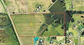
Property Record
Millie Branch Rd, Pike Road, AL 36064

Save to a Folder
{{folder.Name}}
{{folder.ListingIds.length}} Properties
{{folder.ListingIds.length}} Property
Create a New Folder
Property Detail
Millie Branch Rd
Montgomery, AL
0808340000009000
08-08-34-0-000-009.000
MONTGOMERY
Vacantlandnec
Alabama
B and X Area of moderate flood hazard, usually the area between the limits of the 100-year and 500-year floods.
3
2025
28.54 AC
2025
Outlying Montgomery Cnty
005604
Montgomery
NEARBY LISTINGS FOR SALE OR LEASE
DEMOGRAPHICS near Millie Branch Rd
1 mile
3 mile
5 mile
2025 Total Population
1,014
9,153
14,690
2030 Population
1,008
9,198
14,731
Pop Growth 2025-2030
(0.59%)
+ 0.49%
+ 0.28%
Average Age
34
36
38
2025 Total Households
353
3,196
5,035
HH Growth 2025-2030
(0.57%)
+ 0.59%
+ 0.36%
Median Household Inc
$106,250
$126,101
$125,454
Avg Household Size
2.90
2.90
2.80
2025 Avg HH Vehicles
2.00
2.00
2.00
Median Home Value
$401,724
$387,262
$387,247
Median Year Built
2011
2010
2010
Nearby Places
Map Layers
Map Styles
 Street
 Aerial
Layers
 Traffic
 Biking
Places
Listings with unknown addresses are not visible on the map
- Restaurants
- Banks
- Shops
- Fitness
- Groceries
PUBLIC TRANSPORTATION
AIRPORT
Montgomery Regional (Dannelly Field)
Drive
Walk
Distance
Montgomery Regional (Dannelly Field)
34 min
25.9 mi
Freight Ports
Port of Panama City
Drive
Walk
Distance
Port of Panama City
245 min
190.3 mi
SALE & LEASE HISTORY
LISTING DATE
SALE/LEASE

Sep 24, 2016
For Sale
Nearby Properties
Address
Land Use
TOTAL SIZE
Lot Size
Zoning
Address
Land Use
TOTAL SIZE
Lot Size
Zoning
25,762 SF
35.04 AC
PUD
Address
Land Use
TOTAL SIZE
Lot Size
Zoning
9,615 SF
4.16 AC
Address
Land Use
TOTAL SIZE
Lot Size
Zoning
14,917 SF
12.73 AC
Address
Land Use
TOTAL SIZE
Lot Size
Zoning
176.10 AC
Address
Land Use
TOTAL SIZE
Lot Size
Zoning
7,698 SF
28.21 AC
Address
Land Use
TOTAL SIZE
Lot Size
Zoning
Address
Land Use
TOTAL SIZE
Lot Size
Zoning
100.80 AC
AGR-1
Address
Land Use
TOTAL SIZE
Lot Size
Zoning
119.10 AC
Address
Land Use
TOTAL SIZE
Lot Size
Zoning
119.90 AC
Address
Land Use
TOTAL SIZE
Lot Size
Zoning
108.74 AC
Address
Land Use
TOTAL SIZE
Lot Size
Zoning
99.80 AC
Address
Land Use
TOTAL SIZE
Lot Size
Zoning
Address
Land Use
TOTAL SIZE
Lot Size
Zoning
3,696 SF
1.21 AC
PUD
Address
Land Use
TOTAL SIZE
Lot Size
Zoning
7,475 SF
1.16 AC
PUD
Address
Land Use
TOTAL SIZE
Lot Size
Zoning
9,267 SF
1.24 AC
PUD
Address
Land Use
TOTAL SIZE
Lot Size
Zoning
127 AC
Address
Land Use
TOTAL SIZE
Lot Size
Zoning
30.11 AC
Address
Land Use
TOTAL SIZE
Lot Size
Zoning
33.60 AC
Address
Land Use
TOTAL SIZE
Lot Size
Zoning
253 AC
Address
Land Use
TOTAL SIZE
Lot Size
Zoning
75.86 AC
Address
Land Use
TOTAL SIZE
Lot Size
Zoning
253.10 AC
Address
Land Use
TOTAL SIZE
Lot Size
Zoning
6,888 SF
6.70 AC
PUD
Address
Land Use
TOTAL SIZE
Lot Size
Zoning
249.50 AC
Address
Land Use
TOTAL SIZE
Lot Size
Zoning
59.81 AC
Address
Land Use
TOTAL SIZE
Lot Size
Zoning
67.37 AC
Address
Land Use
TOTAL SIZE
Lot Size
Zoning
64.70 AC
Address
Land Use
TOTAL SIZE
Lot Size
Zoning
84.07 AC
Address
Land Use
TOTAL SIZE
Lot Size
Zoning
8,308 SF
2 AC
Address
Land Use
TOTAL SIZE
Lot Size
Zoning
3,742 SF
3.04 AC
Address
Land Use
TOTAL SIZE
Lot Size
Zoning
The World's #1 Commercial Real Estate Marketplace
Connect with us
© 2026 CoStar Group
The information above has been obtained from sources believed reliable. While we do not doubt its accuracy we have not verified it and make no guarantee, warranty or representation about it. It is your responsibility to independently confirm its accuracy and completeness. Any projections, opinions, assumptions, or estimates used are for example only and do not represent the current or future performance of the property. The value of this transaction to you depends on tax and other factors which should be evaluated by your tax, financial, and legal advisors. You and your advisors should conduct a careful, independent investigation of the property to determine to your satisfaction the suitability of the property for your needs.