Property Record
Mina De Oro Rd, Poway, CA 92064


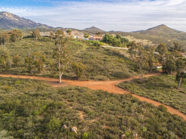

Property Detail
Mina De Oro Rd
San Diego-Chula Vista-Carlsbad, CA
PAR 1 (EX DOC21-0689943) IN TR PM18327
321-111-24
SAN DIEGO
Residentialacreage
California
RR-A
81.04 AC
2024
Poway
2025
San Diego
017041
NEARBY LISTINGS FOR SALE OR LEASE
-
-
View all Poway listings for sale on LoopNet.com
DEMOGRAPHICS near Mina De Oro Rd
1 mile
3 mile
5 mile
2024 Total Population
219
13,556
64,786
2029 Population
217
13,484
64,820
Pop Growth 2024-2029
(0.91%)
(0.53%)
+ 0.05%
Average Age
45
42
43
2024 Total Households
79
4,425
22,696
HH Growth 2024-2029
(1.27%)
(0.75%)
(0.07%)
Median Household Inc
$214,286
$161,357
$146,715
Avg Household Size
2.70
3.00
2.80
2024 Avg HH Vehicles
3.00
3.00
2.00
Median Home Value
$1,085,714
$1,042,966
$1,006,190
Median Year Built
1991
1980
1980
Nearby Places
Map Layers
Map Styles
 Street
 Aerial
Transit
 Traffic
 Biking
Places
Listings with unknown addresses are not visible on the map
- Restaurants
- Banks
- Shops
- Fitness
- Groceries
PUBLIC TRANSPORTATION
AIRPORT
San Diego International
Drive
Walk
Distance
San Diego International
39 min
25.9 mi
Freight Ports
Port of San Diego
Drive
Walk
Distance
Port of San Diego
41 min
28.1 mi
SALE & LEASE HISTORY
LISTING DATE
SALE/LEASE

Feb 27, 2020
For Sale
Nearby Properties
Address
Land Use
TOTAL SIZE
Lot Size
Zoning
Address
Land Use
TOTAL SIZE
Lot Size
Zoning
12.08 AC
RS-2
Address
Land Use
TOTAL SIZE
Lot Size
Zoning
12.91 AC
MHP
Address
Land Use
TOTAL SIZE
Lot Size
Zoning
12.34 AC
MHP
Address
Land Use
TOTAL SIZE
Lot Size
Zoning
18,686 SF
1.28 AC
CG
Address
Land Use
TOTAL SIZE
Lot Size
Zoning
54,288 SF
2.47 AC
CG
Address
Land Use
TOTAL SIZE
Lot Size
Zoning
2.97 AC
RA
Address
Land Use
TOTAL SIZE
Lot Size
Zoning
2.49 AC
RS-4
Address
Land Use
TOTAL SIZE
Lot Size
Zoning
53,274 SF
1.58 AC
PC-8
Address
Land Use
TOTAL SIZE
Lot Size
Zoning
14,380 SF
0.85 AC
CN
Address
Land Use
TOTAL SIZE
Lot Size
Zoning
35,960 SF
1.35 AC
RA
Address
Land Use
TOTAL SIZE
Lot Size
Zoning
5,949 SF
30.36 AC
RR-A
Address
Land Use
TOTAL SIZE
Lot Size
Zoning
7,495 SF
0.54 AC
CG
Address
Land Use
TOTAL SIZE
Lot Size
Zoning
17,073 SF
1.57 AC
PC-8
Address
Land Use
TOTAL SIZE
Lot Size
Zoning
3.21 AC
RR-C
Address
Land Use
TOTAL SIZE
Lot Size
Zoning
7,820 SF
6.71 AC
A70
Address
Land Use
TOTAL SIZE
Lot Size
Zoning
8,475 SF
0.62 AC
PC-8
Address
Land Use
TOTAL SIZE
Lot Size
Zoning
6,822 SF
0.50 AC
CG
Address
Land Use
TOTAL SIZE
Lot Size
Zoning
16,220 SF
1.15 AC
PC-8
Address
Land Use
TOTAL SIZE
Lot Size
Zoning
6,574 SF
1.16 AC
RR-C
Address
Land Use
TOTAL SIZE
Lot Size
Zoning
22,491 SF
1.22 AC
PC-8
Address
Land Use
TOTAL SIZE
Lot Size
Zoning
1,078 SF
109.86 AC
RR-A
Address
Land Use
TOTAL SIZE
Lot Size
Zoning
Address
Land Use
TOTAL SIZE
Lot Size
Zoning
Address
Land Use
TOTAL SIZE
Lot Size
Zoning
Address
Land Use
TOTAL SIZE
Lot Size
Zoning
2,400 SF
0.32 AC
CN
Address
Land Use
TOTAL SIZE
Lot Size
Zoning
Address
Land Use
TOTAL SIZE
Lot Size
Zoning
11,685 SF
1.56 AC
PC-8
Address
Land Use
TOTAL SIZE
Lot Size
Zoning
Address
Land Use
TOTAL SIZE
Lot Size
Zoning
Address
Land Use
TOTAL SIZE
Lot Size
Zoning
2,830 SF
0.65 AC
PC-8
The World's #1 Commercial Real Estate Marketplace
Connect with us
© 2026 CoStar Group
The information above has been obtained from sources believed reliable. While we do not doubt its accuracy we have not verified it and make no guarantee, warranty or representation about it. It is your responsibility to independently confirm its accuracy and completeness. Any projections, opinions, assumptions, or estimates used are for example only and do not represent the current or future performance of the property. The value of this transaction to you depends on tax and other factors which should be evaluated by your tax, financial, and legal advisors. You and your advisors should conduct a careful, independent investigation of the property to determine to your satisfaction the suitability of the property for your needs.