Property Record
Minerva Rd Se, Waynesburg, OH 44688
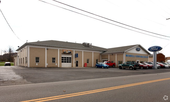
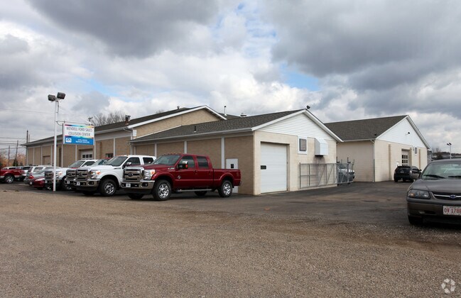
Property Detail
Minerva Rd Se
06101976
21 SE .04A (ALSO SEE 61-00154) (2.00A TOTAL)
Commercialnec
STARK
B and X Area of moderate flood hazard, usually the area between the limits of the 100-year and 500-year floods.
Ohio
0
2.74 AC
2025
Stark County
714902
Cleveland
2,640 SF
Canton-Massillon, OH
NEARBY LISTINGS FOR SALE OR LEASE
DEMOGRAPHICS near Minerva Rd Se
1 mile
3 mile
5 mile
2025 Total Population
1,492
3,848
10,768
2030 Population
1,457
3,794
10,683
Pop Growth 2025-2030
(2.35%)
(1.40%)
(0.79%)
Average Age
42
43
44
2025 Total Households
570
1,537
4,397
HH Growth 2025-2030
(2.28%)
(1.37%)
(0.82%)
Median Household Inc
$58,333
$62,558
$61,162
Avg Household Size
2.60
2.50
2.40
2025 Avg HH Vehicles
2.00
2.00
2.00
Median Home Value
$130,142
$159,315
$176,214
Median Year Built
1948
1961
1967
Nearby Places
Map Layers
Map Styles
 Street
 Aerial
Layers
 Traffic
 Biking
Places
Listings with unknown addresses are not visible on the map
- Restaurants
- Banks
- Shops
- Fitness
- Groceries
PUBLIC TRANSPORTATION
AIRPORT
Akron-Canton Regional
Drive
Walk
Distance
Akron-Canton Regional
33 min
23.3 mi
Freight Ports
Port of Toledo
Drive
Walk
Distance
Port of Toledo
204 min
170.6 mi
SALE & LEASE HISTORY
LISTING DATE
SALE/LEASE

Aug 27, 2024
For Lease
Nearby Properties
Address
Land Use
TOTAL SIZE
Lot Size
Zoning
Address
Land Use
TOTAL SIZE
Lot Size
Zoning
103.11 AC
Address
Land Use
TOTAL SIZE
Lot Size
Zoning
27,063 SF
3.22 AC
Address
Land Use
TOTAL SIZE
Lot Size
Zoning
46,256 SF
8.48 AC
Address
Land Use
TOTAL SIZE
Lot Size
Zoning
12,044 SF
6.64 AC
Address
Land Use
TOTAL SIZE
Lot Size
Zoning
2,160 SF
151.95 AC
Address
Land Use
TOTAL SIZE
Lot Size
Zoning
10,769 SF
147.52 AC
Address
Land Use
TOTAL SIZE
Lot Size
Zoning
10,444 SF
1.50 AC
Address
Land Use
TOTAL SIZE
Lot Size
Zoning
12,882 SF
4.88 AC
Address
Land Use
TOTAL SIZE
Lot Size
Zoning
1,200 SF
164.42 AC
Address
Land Use
TOTAL SIZE
Lot Size
Zoning
2,742 SF
181.75 AC
Address
Land Use
TOTAL SIZE
Lot Size
Zoning
11,532 SF
5.79 AC
Address
Land Use
TOTAL SIZE
Lot Size
Zoning
3,476 SF
35.58 AC
Address
Land Use
TOTAL SIZE
Lot Size
Zoning
19,725 SF
2.11 AC
Address
Land Use
TOTAL SIZE
Lot Size
Zoning
924 SF
252.74 AC
Address
Land Use
TOTAL SIZE
Lot Size
Zoning
2,896 SF
151.77 AC
Address
Land Use
TOTAL SIZE
Lot Size
Zoning
9,179 SF
2.03 AC
Address
Land Use
TOTAL SIZE
Lot Size
Zoning
246.74 AC
Address
Land Use
TOTAL SIZE
Lot Size
Zoning
13,140 SF
1.86 AC
Address
Land Use
TOTAL SIZE
Lot Size
Zoning
4,313 SF
46.36 AC
Address
Land Use
TOTAL SIZE
Lot Size
Zoning
3,080 SF
117.47 AC
Address
Land Use
TOTAL SIZE
Lot Size
Zoning
7,880 SF
79.92 AC
Address
Land Use
TOTAL SIZE
Lot Size
Zoning
137.10 AC
Address
Land Use
TOTAL SIZE
Lot Size
Zoning
22,532 SF
3.49 AC
Address
Land Use
TOTAL SIZE
Lot Size
Zoning
82.62 AC
Address
Land Use
TOTAL SIZE
Lot Size
Zoning
2,190 SF
81.50 AC
Address
Land Use
TOTAL SIZE
Lot Size
Zoning
46,256 SF
7.11 AC
Address
Land Use
TOTAL SIZE
Lot Size
Zoning
4,123 SF
73.57 AC
Address
Land Use
TOTAL SIZE
Lot Size
Zoning
5,852 SF
0.45 AC
Address
Land Use
TOTAL SIZE
Lot Size
Zoning
15,208 SF
0.58 AC
Address
Land Use
TOTAL SIZE
Lot Size
Zoning
4,102 SF
16.40 AC
The World's #1 Commercial Real Estate Marketplace
Connect with us
© 2026 CoStar Group
The information above has been obtained from sources believed reliable. While we do not doubt its accuracy we have not verified it and make no guarantee, warranty or representation about it. It is your responsibility to independently confirm its accuracy and completeness. Any projections, opinions, assumptions, or estimates used are for example only and do not represent the current or future performance of the property. The value of this transaction to you depends on tax and other factors which should be evaluated by your tax, financial, and legal advisors. You and your advisors should conduct a careful, independent investigation of the property to determine to your satisfaction the suitability of the property for your needs.