Property Record
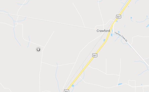
Mitigation Trl, Callahan, FL 32011

Save to a Folder
{{folder.Name}}
{{folder.ListingIds.length}} Properties
{{folder.ListingIds.length}} Property
Create a New Folder
Property Detail
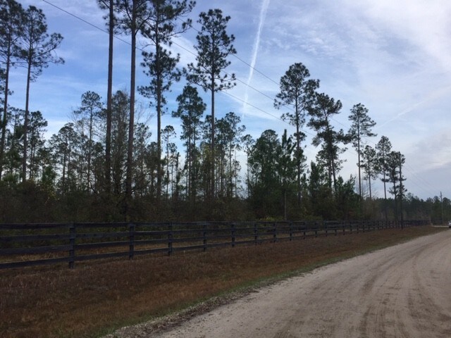
Mitigation Trl
Jacksonville, FL
NE1/4 OF NE1/4 PT OR 1983/4 BEING PARCEL 3
20-1N-24-0000-0001-0000
NASSAU
Timberlandforesttreesagricultural
Florida
OR
1
A Areas with a 1% annual chance of flooding and a 26% chance of flooding over the life of a 30-year mortgage.
40 AC
2025
Nassau County
2025
Jacksonville (Florida)
050509
NEARBY LISTINGS FOR SALE OR LEASE
-
-
View all Callahan listings for sale on LoopNet.com
DEMOGRAPHICS near Mitigation Trl
1 mile
3 mile
5 mile
2025 Total Population
169
843
3,296
2030 Population
188
938
3,657
Pop Growth 2025-2030
+ 11.24%
+ 11.27%
+ 10.95%
Average Age
41
41
42
2025 Total Households
58
296
1,180
HH Growth 2025-2030
+ 10.34%
+ 11.15%
+ 11.10%
Median Household Inc
$54,285
$83,333
$92,100
Avg Household Size
2.70
2.80
2.80
2025 Avg HH Vehicles
2.00
2.00
3.00
Median Home Value
$185,293
$290,243
$324,026
Median Year Built
1995
1998
1999
Nearby Places
Map Layers
Map Styles
 Street
 Aerial
Layers
 Traffic
 Biking
Places
Listings with unknown addresses are not visible on the map
- Restaurants
- Banks
- Shops
- Fitness
- Groceries
PUBLIC TRANSPORTATION
AIRPORT
Jacksonville International
Drive
Walk
Distance
Jacksonville International
42 min
22.6 mi
Freight Ports
Jacksonville Port
Drive
Walk
Distance
Jacksonville Port
50 min
29.3 mi
SALE & LEASE HISTORY
LISTING DATE
SALE/LEASE

Mar 05, 2019
For Sale
Nearby Properties
Address
Land Use
TOTAL SIZE
Lot Size
Zoning
Address
Land Use
TOTAL SIZE
Lot Size
Zoning
480.25 AC
IP
Address
Land Use
TOTAL SIZE
Lot Size
Zoning
640 AC
OR
Address
Land Use
TOTAL SIZE
Lot Size
Zoning
640 AC
OR
Address
Land Use
TOTAL SIZE
Lot Size
Zoning
31.67 AC
IH
Address
Land Use
TOTAL SIZE
Lot Size
Zoning
440 AC
OR
Address
Land Use
TOTAL SIZE
Lot Size
Zoning
440 AC
OR
Address
Land Use
TOTAL SIZE
Lot Size
Zoning
26,995 SF
13.60 AC
OR
Address
Land Use
TOTAL SIZE
Lot Size
Zoning
318 AC
OR
Address
Land Use
TOTAL SIZE
Lot Size
Zoning
279.80 AC
OR
Address
Land Use
TOTAL SIZE
Lot Size
Zoning
18.50 AC
OR
Address
Land Use
TOTAL SIZE
Lot Size
Zoning
4,666 SF
6 AC
OR
Address
Land Use
TOTAL SIZE
Lot Size
Zoning
134.65 AC
OR
Address
Land Use
TOTAL SIZE
Lot Size
Zoning
2,335 SF
12.90 AC
OR
Address
Land Use
TOTAL SIZE
Lot Size
Zoning
4,946 SF
15.45 AC
OR
Address
Land Use
TOTAL SIZE
Lot Size
Zoning
80 AC
OR
Address
Land Use
TOTAL SIZE
Lot Size
Zoning
80 AC
OR
Address
Land Use
TOTAL SIZE
Lot Size
Zoning
4,209 SF
10.12 AC
OR
Address
Land Use
TOTAL SIZE
Lot Size
Zoning
3,364 SF
10.16 AC
Address
Land Use
TOTAL SIZE
Lot Size
Zoning
6,264 SF
10 AC
OR
Address
Land Use
TOTAL SIZE
Lot Size
Zoning
6,538 SF
17.75 AC
OR
Address
Land Use
TOTAL SIZE
Lot Size
Zoning
4,059 SF
10 AC
OR
Address
Land Use
TOTAL SIZE
Lot Size
Zoning
35 AC
OR
Address
Land Use
TOTAL SIZE
Lot Size
Zoning
3,957 SF
8.16 AC
OR
Address
Land Use
TOTAL SIZE
Lot Size
Zoning
22 AC
OR
Address
Land Use
TOTAL SIZE
Lot Size
Zoning
22.68 AC
OR
Address
Land Use
TOTAL SIZE
Lot Size
Zoning
3,100 SF
10 AC
OR
Address
Land Use
TOTAL SIZE
Lot Size
Zoning
103.08 AC
OR
Address
Land Use
TOTAL SIZE
Lot Size
Zoning
35 AC
OR
Address
Land Use
TOTAL SIZE
Lot Size
Zoning
1,650 SF
27.54 AC
OR
Address
Land Use
TOTAL SIZE
Lot Size
Zoning
630 AC
OR
The World's #1 Commercial Real Estate Marketplace
Connect with us
© 2026 CoStar Group
The information above has been obtained from sources believed reliable. While we do not doubt its accuracy we have not verified it and make no guarantee, warranty or representation about it. It is your responsibility to independently confirm its accuracy and completeness. Any projections, opinions, assumptions, or estimates used are for example only and do not represent the current or future performance of the property. The value of this transaction to you depends on tax and other factors which should be evaluated by your tax, financial, and legal advisors. You and your advisors should conduct a careful, independent investigation of the property to determine to your satisfaction the suitability of the property for your needs.