Property Record
11303 Mitt Lary Rd, Northport, AL 35475
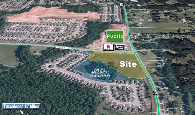

This Property Is For Sale
NEARBY LISTINGS FOR SALE OR LEASE
-
-
View all Northport listings for sale on LoopNet.com
Property Detail
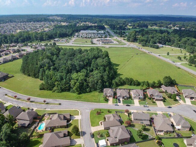
11303 Mitt Lary Rd
Tuscaloosa, AL
Sandy Ridge Subdivision Phase Two
20-05-22-2-001-001.005
PART OF S22 T20S R10W DESC AS: COM NW COR NE1/4; S 260(S) TO POB; E 111(S); SE 597(S); SW 105(S); SE 77(S); SW 222(S); N 813(S) TO POB
Timberlandforesttreesagricultural
Tuscaloosa
X
Alabama
01125C0337G
16 AC
2025
Tuscaloosa
2024
Birmingham
010206
DEMOGRAPHICS near 11303 Mitt Lary Rd
1 Mile
3 Mile
5 Mile
2024 Total Population
2,679
13,136
44,537
2029 Population
2,932
14,414
49,720
Pop Growth 2024-2029
+ 9.44%
+ 9.73%
+ 11.64%
Average Age
39
39
41
2024 Total Households
966
4,881
17,222
HH Growth 2024-2029
+ 9.73%
+ 9.79%
+ 11.68%
Median Household Inc
$105,942
$99,622
$94,896
Avg Household Size
2.80
2.70
2.40
2024 Avg HH Vehicles
2.00
2.00
2.00
Median Home Value
$318,582
$272,334
$281,690
Median Year Built
1998
1997
1993
Nearby Places
Map Layers
Map Styles
 Street
 Aerial
- Restaurants
- Banks
- Shops
- Fitness
- Groceries
PUBLIC TRANSPORTATION
COMMUTER RAIL
Tuscaloosa Amtrak Station (Crescent - Amtrak)
DRIVE
WALK
Distance
Tuscaloosa Amtrak Station (Crescent - Amtrak)
14 min
8.4 mi
Freight Ports
Port of Mobile
DRIVE
WALK
Distance
Port of Mobile
251 min
207.2 mi
Nearby Properties
Address
Land Use
TOTAL SIZE
Lot Size
Zoning
Address
Land Use
TOTAL SIZE
Lot Size
Zoning
20,224 SF
19 AC
RM2
Address
Land Use
TOTAL SIZE
Lot Size
Zoning
4,210 SF
15 AC
RS-SD
Address
Land Use
TOTAL SIZE
Lot Size
Zoning
52,852 SF
10.21 AC
C-3
Address
Land Use
TOTAL SIZE
Lot Size
Zoning
47,657 SF
9.53 AC
C-3
Address
Land Use
TOTAL SIZE
Lot Size
Zoning
37,553 SF
12 AC
O-I
Address
Land Use
TOTAL SIZE
Lot Size
Zoning
4,306 SF
4.60 AC
OI
Address
Land Use
TOTAL SIZE
Lot Size
Zoning
25,451 SF
4.32 AC
C-3
Address
Land Use
TOTAL SIZE
Lot Size
Zoning
5,504 SF
14 AC
Address
Land Use
TOTAL SIZE
Lot Size
Zoning
30,000 SF
5.85 AC
Address
Land Use
TOTAL SIZE
Lot Size
Zoning
25,662 SF
4.09 AC
C3
Address
Land Use
TOTAL SIZE
Lot Size
Zoning
13,775 SF
2.60 AC
C-3
Address
Land Use
TOTAL SIZE
Lot Size
Zoning
12,000 SF
4.28 AC
Address
Land Use
TOTAL SIZE
Lot Size
Zoning
10,486 SF
2.43 AC
C-3
Address
Land Use
TOTAL SIZE
Lot Size
Zoning
32,000 SF
3.30 AC
C3
Address
Land Use
TOTAL SIZE
Lot Size
Zoning
2,960 SF
3.56 AC
C3
Address
Land Use
TOTAL SIZE
Lot Size
Zoning
5,350 SF
1.30 AC
Address
Land Use
TOTAL SIZE
Lot Size
Zoning
12,500 SF
0.60 AC
Address
Land Use
TOTAL SIZE
Lot Size
Zoning
11,760 SF
2.33 AC
Address
Land Use
TOTAL SIZE
Lot Size
Zoning
23,400 SF
8.70 AC
Address
Land Use
TOTAL SIZE
Lot Size
Zoning
5,922 SF
1.04 AC
Address
Land Use
TOTAL SIZE
Lot Size
Zoning
3,486 SF
2 AC
C-3
Address
Land Use
TOTAL SIZE
Lot Size
Zoning
2,500 SF
6.20 AC
Address
Land Use
TOTAL SIZE
Lot Size
Zoning
3,311 SF
1.20 AC
C-3
Address
Land Use
TOTAL SIZE
Lot Size
Zoning
6,206 SF
1.10 AC
Address
Land Use
TOTAL SIZE
Lot Size
Zoning
13,832 SF
3.98 AC
Address
Land Use
TOTAL SIZE
Lot Size
Zoning
10,000 SF
3.99 AC
Address
Land Use
TOTAL SIZE
Lot Size
Zoning
3,348 SF
2.68 AC
Address
Land Use
TOTAL SIZE
Lot Size
Zoning
6,000 SF
2.06 AC
Address
Land Use
TOTAL SIZE
Lot Size
Zoning
2,680 SF
1.12 AC
C-2
Address
Land Use
TOTAL SIZE
Lot Size
Zoning
3,318 SF
1.39 AC
C-3
The World's #1 Commercial Real Estate Marketplace
Connect with us
© 2025 CoStar Group
The information above has been obtained from sources believed reliable. While we do not doubt its accuracy we have not verified it and make no guarantee, warranty or representation about it. It is your responsibility to independently confirm its accuracy and completeness. Any projections, opinions, assumptions, or estimates used are for example only and do not represent the current or future performance of the property. The value of this transaction to you depends on tax and other factors which should be evaluated by your tax, financial, and legal advisors. You and your advisors should conduct a careful, independent investigation of the property to determine to your satisfaction the suitability of the property for your needs.