Property Record
Mlk Jr East 36Th St N, Tulsa, OK 74106

NEARBY LISTINGS FOR SALE OR LEASE
Property Detail
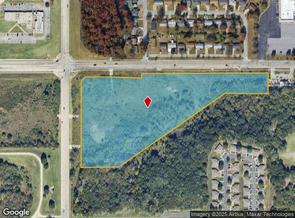
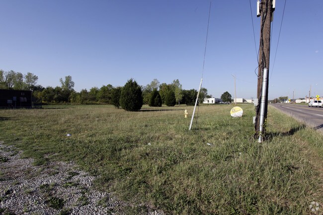
Mlk Jr East 36Th St N
Tulsa, OK
Carls Commercial Center
06750-02-24-00600
LTS 1 2 & 3 & PRT LT 4 & PRT VAC ST BEG 50E SWC LT 4 TH N558.70 NE35.36 E375 N25 E827.15 S130 W277.50 SW846.15 W250 POB BLK 1
Commercialacreage
Tulsa
X
Oklahoma
40143C0228L
1
2025
10.03 AC
2025
Northwest
011400
Tulsa
DEMOGRAPHICS near Mlk Jr East 36Th St N
1 Mile
3 Mile
5 Mile
2024 Total Population
5,460
42,927
104,899
2029 Population
5,750
45,012
110,234
Pop Growth 2024-2029
+ 5.31%
+ 4.86%
+ 5.09%
Average Age
39
37
37
2024 Total Households
2,177
16,359
42,035
HH Growth 2024-2029
+ 5.33%
+ 4.85%
+ 5.38%
Median Household Inc
$29,747
$32,575
$38,320
Avg Household Size
2.40
2.50
2.30
2024 Avg HH Vehicles
1.00
2.00
2.00
Median Home Value
$59,338
$83,511
$89,629
Median Year Built
1957
1960
1958
Nearby Places
Map Layers
Map Styles
 Street
 Aerial
- Restaurants
- Banks
- Shops
- Fitness
- Groceries
PUBLIC TRANSPORTATION
AIRPORT
Tulsa International
DRIVE
WALK
Distance
Tulsa International
12 min
6.4 mi
Freight Ports
Tulsa Port Of Catoosa
DRIVE
WALK
Distance
Tulsa Port Of Catoosa
22 min
14.6 mi
SALE & LEASE HISTORY
LISTING DATE
SALE/LEASE

Sep 24, 2016
For Sale
Nearby Properties
Address
Land Use
TOTAL SIZE
Lot Size
Zoning
Address
Land Use
TOTAL SIZE
Lot Size
Zoning
10,736 SF
101.62 AC
Address
Land Use
TOTAL SIZE
Lot Size
Zoning
92,407 SF
6.02 AC
CS
Address
Land Use
TOTAL SIZE
Lot Size
Zoning
144,570 SF
44.59 AC
RM2
Address
Land Use
TOTAL SIZE
Lot Size
Zoning
161,670 SF
8.57 AC
IL
Address
Land Use
TOTAL SIZE
Lot Size
Zoning
106,579 SF
6.76 AC
RM1
Address
Land Use
TOTAL SIZE
Lot Size
Zoning
56,476 SF
2.89 AC
RM2
Address
Land Use
TOTAL SIZE
Lot Size
Zoning
67,334 SF
0.84 AC
IL
Address
Land Use
TOTAL SIZE
Lot Size
Zoning
40,433 SF
2.92 AC
IL
Address
Land Use
TOTAL SIZE
Lot Size
Zoning
29,589 SF
12.37 AC
AG
Address
Land Use
TOTAL SIZE
Lot Size
Zoning
29,584 SF
2.99 AC
IM
Address
Land Use
TOTAL SIZE
Lot Size
Zoning
29,110 SF
3.96 AC
IL
Address
Land Use
TOTAL SIZE
Lot Size
Zoning
92,364 SF
8.58 AC
RM1
Address
Land Use
TOTAL SIZE
Lot Size
Zoning
149,204 SF
3.48 AC
CH
Address
Land Use
TOTAL SIZE
Lot Size
Zoning
84,400 SF
2.79 AC
CH
Address
Land Use
TOTAL SIZE
Lot Size
Zoning
41,728 SF
10.07 AC
RS3
Address
Land Use
TOTAL SIZE
Lot Size
Zoning
33,340 SF
10.08 AC
AG
Address
Land Use
TOTAL SIZE
Lot Size
Zoning
33,750 SF
5.07 AC
RM1
Address
Land Use
TOTAL SIZE
Lot Size
Zoning
39,889 SF
3.62 AC
IL
Address
Land Use
TOTAL SIZE
Lot Size
Zoning
20,818 SF
2.09 AC
RS4
Address
Land Use
TOTAL SIZE
Lot Size
Zoning
43,225 SF
9.30 AC
RS3
Address
Land Use
TOTAL SIZE
Lot Size
Zoning
16,164 SF
1.23 AC
CN
Address
Land Use
TOTAL SIZE
Lot Size
Zoning
45,883 SF
10.29 AC
RS3
Address
Land Use
TOTAL SIZE
Lot Size
Zoning
55,867 SF
7.94 AC
RS
Address
Land Use
TOTAL SIZE
Lot Size
Zoning
51,810 SF
7.61 AC
CS
Address
Land Use
TOTAL SIZE
Lot Size
Zoning
27,403 SF
70.91 AC
AG
Address
Land Use
TOTAL SIZE
Lot Size
Zoning
35,336 SF
1.68 AC
RS3
Address
Land Use
TOTAL SIZE
Lot Size
Zoning
14,400 SF
2.32 AC
IL
Address
Land Use
TOTAL SIZE
Lot Size
Zoning
24,812 SF
1.13 AC
CH
Address
Land Use
TOTAL SIZE
Lot Size
Zoning
22,406 SF
2.91 AC
CH
The World's #1 Commercial Real Estate Marketplace
Connect with us
© 2025 CoStar Group
The information above has been obtained from sources believed reliable. While we do not doubt its accuracy we have not verified it and make no guarantee, warranty or representation about it. It is your responsibility to independently confirm its accuracy and completeness. Any projections, opinions, assumptions, or estimates used are for example only and do not represent the current or future performance of the property. The value of this transaction to you depends on tax and other factors which should be evaluated by your tax, financial, and legal advisors. You and your advisors should conduct a careful, independent investigation of the property to determine to your satisfaction the suitability of the property for your needs.