Property Record
153 Money Hill Rd, Chepachet, RI 02814

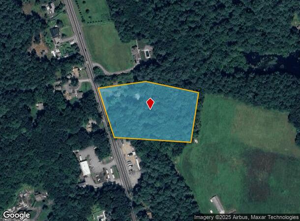
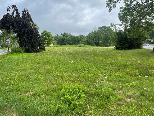
This Property Is For Sale
NEARBY LISTINGS FOR SALE OR LEASE
Property Detail
153 Money Hill Rd
Providence-Warwick, RI-MA
Providence
GLOC-000010-000000-000110
Rhode Island
Sfr
4.37 AC
X
Burrillville/Glocester
44007C0145G
Providence
990 SF
DEMOGRAPHICS near 153 Money Hill Rd
1 Mile
3 Mile
5 Mile
2024 Total Population
702
12,423
23,026
2029 Population
710
12,631
23,344
Pop Growth 2024-2029
+ 1.14%
+ 1.67%
+ 1.38%
Average Age
45
43
43
2024 Total Households
292
4,835
8,921
HH Growth 2024-2029
+ 1.03%
+ 1.57%
+ 1.23%
Median Household Inc
$97,033
$95,568
$98,441
Avg Household Size
2.40
2.50
2.50
2024 Avg HH Vehicles
2.00
2.00
2.00
Median Home Value
$367,777
$362,556
$367,296
Median Year Built
1969
1971
1972
Nearby Places
Map Layers
Map Styles
 Street
 Aerial
- Restaurants
- Banks
- Shops
- Fitness
- Groceries
PUBLIC TRANSPORTATION
AIRPORT
Rhode Island Tf Green International
DRIVE
WALK
Distance
Rhode Island Tf Green International
37 min
23.8 mi
Worcester Regional
DRIVE
WALK
Distance
Worcester Regional
52 min
36.3 mi
Freight Ports
Port of Davisville, RI
DRIVE
WALK
Distance
Port of Davisville, RI
49 min
33.1 mi
Nearby Properties
Address
Land Use
TOTAL SIZE
Lot Size
Zoning
Address
Land Use
TOTAL SIZE
Lot Size
Zoning
64.77 AC
GI
Address
Land Use
TOTAL SIZE
Lot Size
Zoning
192.38 AC
R20
Address
Land Use
TOTAL SIZE
Lot Size
Zoning
85,200 SF
3.86 AC
VC
Address
Land Use
TOTAL SIZE
Lot Size
Zoning
42,504 SF
10.35 AC
R40
Address
Land Use
TOTAL SIZE
Lot Size
Zoning
151,584 SF
7.61 AC
GI
Address
Land Use
TOTAL SIZE
Lot Size
Zoning
173.57 AC
20
Address
Land Use
TOTAL SIZE
Lot Size
Zoning
66,069 SF
2.28 AC
VCVP
Address
Land Use
TOTAL SIZE
Lot Size
Zoning
44.50 AC
F5
Address
Land Use
TOTAL SIZE
Lot Size
Zoning
23,937 SF
2.34 AC
VCVP
Address
Land Use
TOTAL SIZE
Lot Size
Zoning
5,011 SF
6.98 AC
R12
Address
Land Use
TOTAL SIZE
Lot Size
Zoning
48,902 SF
4.35 AC
VCVP
Address
Land Use
TOTAL SIZE
Lot Size
Zoning
44.16 AC
GI
Address
Land Use
TOTAL SIZE
Lot Size
Zoning
43,999 SF
7.79 AC
GI
Address
Land Use
TOTAL SIZE
Lot Size
Zoning
38,796 SF
1.33 AC
VC
Address
Land Use
TOTAL SIZE
Lot Size
Zoning
16,711 SF
2.06 AC
40
Address
Land Use
TOTAL SIZE
Lot Size
Zoning
14,239 SF
186.15 AC
R40
Address
Land Use
TOTAL SIZE
Lot Size
Zoning
16.05 AC
80
Address
Land Use
TOTAL SIZE
Lot Size
Zoning
40,110 SF
6.49 AC
VC
Address
Land Use
TOTAL SIZE
Lot Size
Zoning
29,668 SF
1.18 AC
GI
Address
Land Use
TOTAL SIZE
Lot Size
Zoning
52,200 SF
3.44 AC
GI
Address
Land Use
TOTAL SIZE
Lot Size
Zoning
0.97 AC
R12
Address
Land Use
TOTAL SIZE
Lot Size
Zoning
40,767 SF
32.40 AC
R40
Address
Land Use
TOTAL SIZE
Lot Size
Zoning
2,772 SF
230.76 AC
F5
Address
Land Use
TOTAL SIZE
Lot Size
Zoning
25,950 SF
4.99 AC
40
Address
Land Use
TOTAL SIZE
Lot Size
Zoning
10,775 SF
2.27 AC
VC
Address
Land Use
TOTAL SIZE
Lot Size
Zoning
68.30 AC
GI
Address
Land Use
TOTAL SIZE
Lot Size
Zoning
8.76 AC
80
Address
Land Use
TOTAL SIZE
Lot Size
Zoning
10.22 AC
1
Address
Land Use
TOTAL SIZE
Lot Size
Zoning
26,354 SF
6.89 AC
VC
Address
Land Use
TOTAL SIZE
Lot Size
Zoning
31,659 SF
21.32 AC
GI
The World's #1 Commercial Real Estate Marketplace
Connect with us
© 2026 CoStar Group
The information above has been obtained from sources believed reliable. While we do not doubt its accuracy we have not verified it and make no guarantee, warranty or representation about it. It is your responsibility to independently confirm its accuracy and completeness. Any projections, opinions, assumptions, or estimates used are for example only and do not represent the current or future performance of the property. The value of this transaction to you depends on tax and other factors which should be evaluated by your tax, financial, and legal advisors. You and your advisors should conduct a careful, independent investigation of the property to determine to your satisfaction the suitability of the property for your needs.