Property Record
Monkton Rd, Phoenix, MD 21131
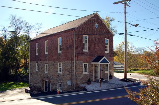
This Property Is For Sale
NEARBY LISTINGS FOR SALE OR LEASE
Property Detail
Monkton Rd
10-1023000700
.177 AC
Residentialnec
Baltimore
A
Maryland
2400100130G
0.50 AC
2024
Route 83 Corridor North
2025
Baltimore
410100
Baltimore-Columbia-Towson, MD
DEMOGRAPHICS near Monkton Rd
1 mile
3 mile
5 mile
2024 Total Population
585
4,415
13,445
2029 Population
569
4,298
13,188
Pop Growth 2024-2029
(2.74%)
(2.65%)
(1.91%)
Average Age
45
44
44
2024 Total Households
214
1,596
5,160
HH Growth 2024-2029
(2.80%)
(2.76%)
(1.96%)
Median Household Inc
$138,461
$140,624
$123,488
Avg Household Size
2.60
2.70
2.50
2024 Avg HH Vehicles
2.00
3.00
2.00
Median Home Value
$668,032
$631,787
$535,223
Median Year Built
1975
1980
1983
Nearby Places
Map Layers
Map Styles
 Street
 Aerial
Transit
 Traffic
 Biking
Places
Listings with unknown addresses are not visible on the map
- Restaurants
- Banks
- Shops
- Fitness
- Groceries
PUBLIC TRANSPORTATION
AIRPORT
Baltimore/Washington International Thurgood Marshall
Drive
Walk
Distance
Baltimore/Washington International Thurgood Marshall
56 min
38.9 mi
Freight Ports
Port of Baltimore
Drive
Walk
Distance
Port of Baltimore
50 min
30.6 mi
Nearby Properties
Address
Land Use
TOTAL SIZE
Lot Size
Zoning
Address
Land Use
TOTAL SIZE
Lot Size
Zoning
230,793 SF
103 AC
Address
Land Use
TOTAL SIZE
Lot Size
Zoning
2,522 SF
100.68 AC
RC4
Address
Land Use
TOTAL SIZE
Lot Size
Zoning
5,000 SF
190.47 AC
ML
Address
Land Use
TOTAL SIZE
Lot Size
Zoning
13,242 SF
12.97 AC
Address
Land Use
TOTAL SIZE
Lot Size
Zoning
15,168 SF
0.80 AC
BM-CR
Address
Land Use
TOTAL SIZE
Lot Size
Zoning
5,128 SF
2.51 AC
Address
Land Use
TOTAL SIZE
Lot Size
Zoning
15,850 SF
24.57 AC
Address
Land Use
TOTAL SIZE
Lot Size
Zoning
2,492 SF
228.70 AC
Address
Land Use
TOTAL SIZE
Lot Size
Zoning
21,988 SF
2 AC
Address
Land Use
TOTAL SIZE
Lot Size
Zoning
22,697 SF
92.32 AC
Address
Land Use
TOTAL SIZE
Lot Size
Zoning
8,971 SF
12.55 AC
Address
Land Use
TOTAL SIZE
Lot Size
Zoning
8,071 SF
10.92 AC
Address
Land Use
TOTAL SIZE
Lot Size
Zoning
4,227 SF
14.65 AC
Address
Land Use
TOTAL SIZE
Lot Size
Zoning
9,364 SF
10.28 AC
Address
Land Use
TOTAL SIZE
Lot Size
Zoning
9,241 SF
18.53 AC
RC2
Address
Land Use
TOTAL SIZE
Lot Size
Zoning
8,724 SF
27.65 AC
Address
Land Use
TOTAL SIZE
Lot Size
Zoning
11,520 SF
7.90 AC
Address
Land Use
TOTAL SIZE
Lot Size
Zoning
16,343 SF
4.11 AC
Address
Land Use
TOTAL SIZE
Lot Size
Zoning
7,201 SF
4.48 AC
Address
Land Use
TOTAL SIZE
Lot Size
Zoning
8,907 SF
9.21 AC
Address
Land Use
TOTAL SIZE
Lot Size
Zoning
188.19 AC
Address
Land Use
TOTAL SIZE
Lot Size
Zoning
9,875 SF
100 AC
Address
Land Use
TOTAL SIZE
Lot Size
Zoning
6,354 SF
24.72 AC
Address
Land Use
TOTAL SIZE
Lot Size
Zoning
5,364 SF
4 AC
RC4
Address
Land Use
TOTAL SIZE
Lot Size
Zoning
5,664 SF
20 AC
Address
Land Use
TOTAL SIZE
Lot Size
Zoning
10,369 SF
23.16 AC
RC2
Address
Land Use
TOTAL SIZE
Lot Size
Zoning
12,501 SF
3.45 AC
Address
Land Use
TOTAL SIZE
Lot Size
Zoning
10,028 SF
3.01 AC
Address
Land Use
TOTAL SIZE
Lot Size
Zoning
11,420 SF
1.38 AC
BM-CR
Address
Land Use
TOTAL SIZE
Lot Size
Zoning
9,162 SF
12.30 AC
The World's #1 Commercial Real Estate Marketplace
Connect with us
© 2026 CoStar Group
The information above has been obtained from sources believed reliable. While we do not doubt its accuracy we have not verified it and make no guarantee, warranty or representation about it. It is your responsibility to independently confirm its accuracy and completeness. Any projections, opinions, assumptions, or estimates used are for example only and do not represent the current or future performance of the property. The value of this transaction to you depends on tax and other factors which should be evaluated by your tax, financial, and legal advisors. You and your advisors should conduct a careful, independent investigation of the property to determine to your satisfaction the suitability of the property for your needs.