Property Record
8880 Monroe Rd, Durand, MI 48429
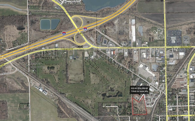
This Property Is For Sale
NEARBY LISTINGS FOR SALE OR LEASE
-
-
View all Durand listings for sale on LoopNet.com
Property Detail
8880 Monroe Rd
Owosso, MI
Neqtrs16t6nr4e
020-82-014-008-02
PART OF THE NE 14 OF SEC 16 T6N R4E CITY OF DURAND, SHIAWASSEE COUNTY DESCRIBED AS BEG AT A PT S0D16'15! ON THE E LN OF SAID
Commercialacreage
Shiawassee
X
Michigan
26155C0300C
7.27 AC
2024
Midland/Flint
2025
Other Market Areas
031800
DEMOGRAPHICS near 8880 Monroe Rd
1 Mile
3 Mile
5 Mile
2024 Total Population
3,025
7,394
13,127
2029 Population
3,062
7,574
13,121
Pop Growth 2024-2029
+ 1.22%
+ 2.43%
(0.05%)
Average Age
42
44
44
2024 Total Households
1,290
3,213
5,482
HH Growth 2024-2029
+ 1.24%
+ 2.80%
+ 0.29%
Median Household Inc
$47,788
$53,443
$55,313
Avg Household Size
2.30
2.20
2.30
2024 Avg HH Vehicles
2.00
2.00
2.00
Median Home Value
$125,518
$133,044
$149,261
Median Year Built
1949
1965
1970
Nearby Places
Map Layers
Map Styles
 Street
 Aerial
- Restaurants
- Banks
- Shops
- Fitness
- Groceries
PUBLIC TRANSPORTATION
COMMUTER RAIL
Durand Amtrak Station (Blue Water - Amtrak)
DRIVE
WALK
Distance
Durand Amtrak Station (Blue Water - Amtrak)
5 min
1.8 mi
AIRPORT
Bishop International
DRIVE
WALK
Distance
Bishop International
30 min
17.6 mi
Freight Ports
Port of Toledo
DRIVE
WALK
Distance
Port of Toledo
148 min
126.5 mi
Nearby Properties
Address
Land Use
TOTAL SIZE
Lot Size
Zoning
Address
Land Use
TOTAL SIZE
Lot Size
Zoning
46,164 SF
5.51 AC
R-M
Address
Land Use
TOTAL SIZE
Lot Size
Zoning
12,890 SF
0.54 AC
R-1
Address
Land Use
TOTAL SIZE
Lot Size
Zoning
118,988 SF
22.79 AC
I-2
Address
Land Use
TOTAL SIZE
Lot Size
Zoning
87,234 SF
8.33 AC
R-M
Address
Land Use
TOTAL SIZE
Lot Size
Zoning
32,792 SF
11.52 AC
C-2
Address
Land Use
TOTAL SIZE
Lot Size
Zoning
66 AC
Address
Land Use
TOTAL SIZE
Lot Size
Zoning
67.70 AC
Address
Land Use
TOTAL SIZE
Lot Size
Zoning
18,780 SF
2.52 AC
R-M
Address
Land Use
TOTAL SIZE
Lot Size
Zoning
19,800 SF
2.66 AC
R-M
Address
Land Use
TOTAL SIZE
Lot Size
Zoning
7.01 AC
Address
Land Use
TOTAL SIZE
Lot Size
Zoning
8.10 AC
Address
Land Use
TOTAL SIZE
Lot Size
Zoning
27,888 SF
2.59 AC
C-1
Address
Land Use
TOTAL SIZE
Lot Size
Zoning
3.70 AC
Address
Land Use
TOTAL SIZE
Lot Size
Zoning
15,000 SF
3.03 AC
I-2
Address
Land Use
TOTAL SIZE
Lot Size
Zoning
179.46 AC
Address
Land Use
TOTAL SIZE
Lot Size
Zoning
27.60 AC
Address
Land Use
TOTAL SIZE
Lot Size
Zoning
11,100 SF
1.57 AC
C-2
Address
Land Use
TOTAL SIZE
Lot Size
Zoning
11,703 SF
1.99 AC
C-2
Address
Land Use
TOTAL SIZE
Lot Size
Zoning
3,168 SF
1.09 AC
C-2
Address
Land Use
TOTAL SIZE
Lot Size
Zoning
5,600 SF
0.69 AC
R-1
Address
Land Use
TOTAL SIZE
Lot Size
Zoning
Address
Land Use
TOTAL SIZE
Lot Size
Zoning
16.48 AC
Address
Land Use
TOTAL SIZE
Lot Size
Zoning
Address
Land Use
TOTAL SIZE
Lot Size
Zoning
Address
Land Use
TOTAL SIZE
Lot Size
Zoning
9,301 SF
2.29 AC
R-M
Address
Land Use
TOTAL SIZE
Lot Size
Zoning
20,982 SF
2.88 AC
R-M
Address
Land Use
TOTAL SIZE
Lot Size
Zoning
1,560 SF
0.96 AC
C-2
Address
Land Use
TOTAL SIZE
Lot Size
Zoning
146.30 AC
Address
Land Use
TOTAL SIZE
Lot Size
Zoning
Address
Land Use
TOTAL SIZE
Lot Size
Zoning
19,200 SF
1.44 AC
R-M
The World's #1 Commercial Real Estate Marketplace
Connect with us
© 2026 CoStar Group
The information above has been obtained from sources believed reliable. While we do not doubt its accuracy we have not verified it and make no guarantee, warranty or representation about it. It is your responsibility to independently confirm its accuracy and completeness. Any projections, opinions, assumptions, or estimates used are for example only and do not represent the current or future performance of the property. The value of this transaction to you depends on tax and other factors which should be evaluated by your tax, financial, and legal advisors. You and your advisors should conduct a careful, independent investigation of the property to determine to your satisfaction the suitability of the property for your needs.