No Photo
Property Record
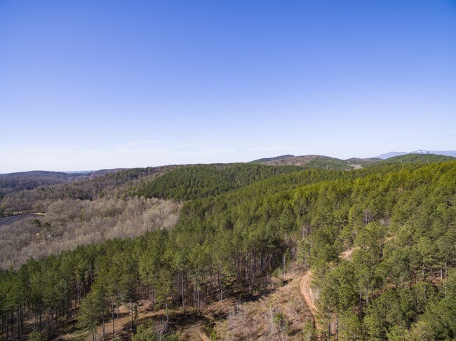
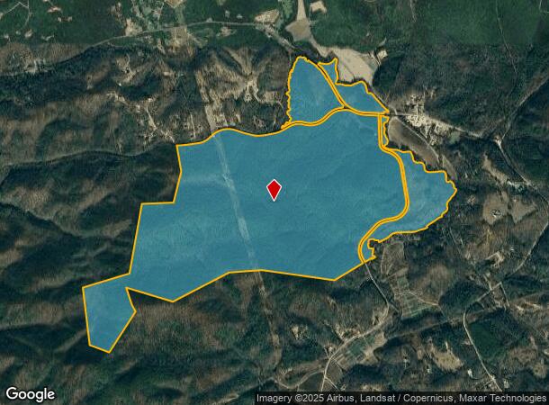
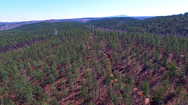
Moody Bridge Rd, , SC
Property Detail
Moody Bridge Rd
Greenville-Anderson-Greer, SC
Plat For Milliken And Company
0673.02-01-004.00
MAP 0673.02
Residentialacreage
Greenville
A
South Carolina
45045C0200E
004.00
2025
849.30 AC
2025
Travelers Rest
004102
Greenville/Spartanburg
NEARBY LISTINGS FOR SALE OR LEASE
-
-
View all listings for sale on LoopNet.com
DEMOGRAPHICS near Moody Bridge Rd
1 mile
3 mile
5 mile
2024 Total Population
167
2,224
7,379
2029 Population
186
2,491
8,238
Pop Growth 2024-2029
+ 11.38%
+ 12.01%
+ 11.64%
Average Age
45
45
45
2024 Total Households
69
916
3,028
HH Growth 2024-2029
+ 11.59%
+ 12.34%
+ 11.89%
Median Household Inc
$54,166
$62,245
$61,135
Avg Household Size
2.30
2.30
2.40
2024 Avg HH Vehicles
2.00
2.00
2.00
Median Home Value
$227,272
$208,015
$199,453
Median Year Built
1993
1991
1992
Nearby Places
Map Layers
Map Styles
 Street
 Aerial
Transit
 Traffic
 Biking
Places
Listings with unknown addresses are not visible on the map
- Restaurants
- Banks
- Shops
- Fitness
- Groceries
PUBLIC TRANSPORTATION
AIRPORT
Greenville Spartanburg International
Drive
Walk
Distance
Greenville Spartanburg International
54 min
29.4 mi
Asheville Regional
Drive
Walk
Distance
Asheville Regional
50 min
36.9 mi
Freight Ports
North Charleston Terminal
Drive
Walk
Distance
North Charleston Terminal
267 min
224.0 mi
SALE & LEASE HISTORY
LISTING DATE
SALE/LEASE

Jul 28, 2017
For Sale
Nearby Properties
Address
Land Use
TOTAL SIZE
Lot Size
Zoning
Address
Land Use
TOTAL SIZE
Lot Size
Zoning
1,611 SF
875 AC
UNZONED
Address
Land Use
TOTAL SIZE
Lot Size
Zoning
822 AC
UNZONED
Address
Land Use
TOTAL SIZE
Lot Size
Zoning
471.17 AC
UNZONED
Address
Land Use
TOTAL SIZE
Lot Size
Zoning
1,652 SF
116.25 AC
UNZONED
Address
Land Use
TOTAL SIZE
Lot Size
Zoning
162.86 AC
UNZONED
Address
Land Use
TOTAL SIZE
Lot Size
Zoning
135.39 AC
UNZONED
Address
Land Use
TOTAL SIZE
Lot Size
Zoning
Address
Land Use
TOTAL SIZE
Lot Size
Zoning
85 AC
UNZONED
Address
Land Use
TOTAL SIZE
Lot Size
Zoning
1.03 AC
Address
Land Use
TOTAL SIZE
Lot Size
Zoning
1,148 SF
47.55 AC
UNZONED
Address
Land Use
TOTAL SIZE
Lot Size
Zoning
68.14 AC
UNZONED
Address
Land Use
TOTAL SIZE
Lot Size
Zoning
66.66 AC
UNZONED
Address
Land Use
TOTAL SIZE
Lot Size
Zoning
1,922 SF
24.04 AC
UNZONED
Address
Land Use
TOTAL SIZE
Lot Size
Zoning
1,888 SF
22.60 AC
NZ
Address
Land Use
TOTAL SIZE
Lot Size
Zoning
0.68 AC
Address
Land Use
TOTAL SIZE
Lot Size
Zoning
2,016 SF
2.12 AC
UNZONED
Address
Land Use
TOTAL SIZE
Lot Size
Zoning
16.30 AC
UNZONED
Address
Land Use
TOTAL SIZE
Lot Size
Zoning
2,602 SF
1.67 AC
UNZONED
Address
Land Use
TOTAL SIZE
Lot Size
Zoning
18 AC
UNZONED
Address
Land Use
TOTAL SIZE
Lot Size
Zoning
18.50 AC
UNZONED
Address
Land Use
TOTAL SIZE
Lot Size
Zoning
12.08 AC
UNZONED
Address
Land Use
TOTAL SIZE
Lot Size
Zoning
9.20 AC
UNZONED
Address
Land Use
TOTAL SIZE
Lot Size
Zoning
2,434 SF
7.37 AC
UNZONED
Address
Land Use
TOTAL SIZE
Lot Size
Zoning
11.30 AC
UNZONED
Address
Land Use
TOTAL SIZE
Lot Size
Zoning
9.30 AC
UNZONED
Address
Land Use
TOTAL SIZE
Lot Size
Zoning
6,375 SF
84.32 AC
UNZONED
Address
Land Use
TOTAL SIZE
Lot Size
Zoning
2.99 AC
UNZONED
Address
Land Use
TOTAL SIZE
Lot Size
Zoning
900 SF
5.82 AC
UNZONED
Address
Land Use
TOTAL SIZE
Lot Size
Zoning
3,294 SF
5.19 AC
UNZONED
The World's #1 Commercial Real Estate Marketplace
Connect with us
© 2026 CoStar Group
The information above has been obtained from sources believed reliable. While we do not doubt its accuracy we have not verified it and make no guarantee, warranty or representation about it. It is your responsibility to independently confirm its accuracy and completeness. Any projections, opinions, assumptions, or estimates used are for example only and do not represent the current or future performance of the property. The value of this transaction to you depends on tax and other factors which should be evaluated by your tax, financial, and legal advisors. You and your advisors should conduct a careful, independent investigation of the property to determine to your satisfaction the suitability of the property for your needs.