Property Record
Moores Chapel Rd, Charlotte, NC 28214
NEARBY LISTINGS FOR SALE OR LEASE
Property Detail
Moores Chapel Rd
Charlotte-Concord-Gastonia, NC-SC
Jeff S Hladun Surv
055-111-31
SEE 5511131
Sfr
Mecklenburg
X
North Carolina
3710451600K
31
2024
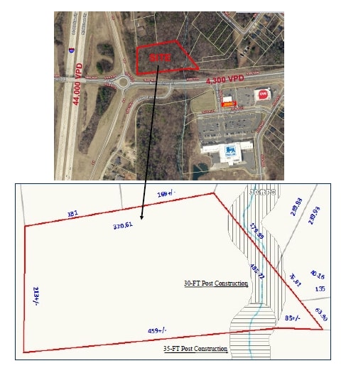
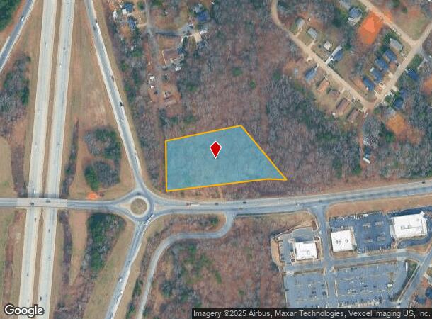
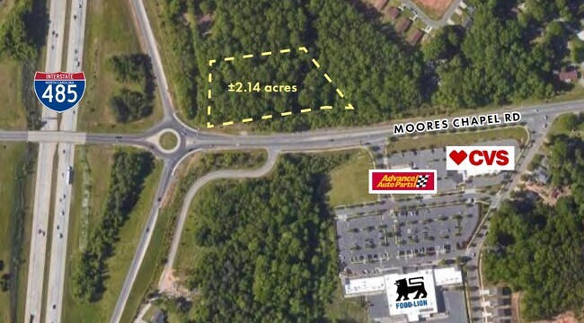
2.19 AC
2025
Northwest Charlotte
006011
Charlotte
DEMOGRAPHICS near Moores Chapel Rd
1 mile
3 mile
5 mile
2024 Total Population
7,124
40,006
108,574
2029 Population
7,652
42,454
115,790
Pop Growth 2024-2029
+ 7.41%
+ 6.12%
+ 6.65%
Average Age
35
37
37
2024 Total Households
2,433
14,176
40,818
HH Growth 2024-2029
+ 7.48%
+ 6.18%
+ 6.80%
Median Household Inc
$65,903
$69,447
$61,557
Avg Household Size
2.80
2.70
2.60
2024 Avg HH Vehicles
2.00
2.00
2.00
Median Home Value
$181,676
$211,615
$220,650
Median Year Built
1989
1995
1992
Nearby Places
Map Layers
Map Styles
 Street
 Aerial
Transit
 Traffic
 Biking
Places
Listings with unknown addresses are not visible on the map
- Restaurants
- Banks
- Shops
- Fitness
- Groceries
PUBLIC TRANSPORTATION
AIRPORT
Charlotte/Douglas International
Drive
Walk
Distance
Charlotte/Douglas International
18 min
6.5 mi
Concord-Padgett Regional
Drive
Walk
Distance
Concord-Padgett Regional
24 min
18.6 mi
SALE & LEASE HISTORY
LISTING DATE
SALE/LEASE

Sep 24, 2016
For Sale
Nearby Properties
Address
Land Use
TOTAL SIZE
Lot Size
Zoning
Address
Land Use
TOTAL SIZE
Lot Size
Zoning
863,490 SF
93.41 AC
Address
Land Use
TOTAL SIZE
Lot Size
Zoning
15.94 AC
Address
Land Use
TOTAL SIZE
Lot Size
Zoning
625,790 SF
89.50 AC
I-2(CD)
Address
Land Use
TOTAL SIZE
Lot Size
Zoning
568,252 SF
56.05 AC
I-1(CD)
Address
Land Use
TOTAL SIZE
Lot Size
Zoning
394,084 SF
29.35 AC
Address
Land Use
TOTAL SIZE
Lot Size
Zoning
238,075 SF
9.52 AC
Address
Land Use
TOTAL SIZE
Lot Size
Zoning
503,550 SF
59.24 AC
I-1(CD)
Address
Land Use
TOTAL SIZE
Lot Size
Zoning
250,079 SF
52.97 AC
R3
Address
Land Use
TOTAL SIZE
Lot Size
Zoning
450,580 SF
36.74 AC
I-2(CD)
Address
Land Use
TOTAL SIZE
Lot Size
Zoning
3,428 SF
13.21 AC
R-17MF
Address
Land Use
TOTAL SIZE
Lot Size
Zoning
471,960 SF
61.08 AC
Address
Land Use
TOTAL SIZE
Lot Size
Zoning
208,635 SF
50.01 AC
Address
Land Use
TOTAL SIZE
Lot Size
Zoning
351,824 SF
20.17 AC
I-1(CD)
Address
Land Use
TOTAL SIZE
Lot Size
Zoning
208,460 SF
23.20 AC
I-1(CD)
Address
Land Use
TOTAL SIZE
Lot Size
Zoning
346,795 SF
110.06 AC
I2
Address
Land Use
TOTAL SIZE
Lot Size
Zoning
251,672 SF
26.13 AC
I1CD
Address
Land Use
TOTAL SIZE
Lot Size
Zoning
171,037 SF
4.37 AC
Address
Land Use
TOTAL SIZE
Lot Size
Zoning
260,575 SF
17 AC
I-1(CD)
Address
Land Use
TOTAL SIZE
Lot Size
Zoning
249,645 SF
26.33 AC
I-1(CD)
Address
Land Use
TOTAL SIZE
Lot Size
Zoning
252,539 SF
22.58 AC
R-3
Address
Land Use
TOTAL SIZE
Lot Size
Zoning
116,515 SF
4.59 AC
I1
Address
Land Use
TOTAL SIZE
Lot Size
Zoning
401,879 SF
20.57 AC
I-1
Address
Land Use
TOTAL SIZE
Lot Size
Zoning
255,566 SF
21.29 AC
I-1(CD)
Address
Land Use
TOTAL SIZE
Lot Size
Zoning
116,877 SF
38.58 AC
I2
Address
Land Use
TOTAL SIZE
Lot Size
Zoning
61,665 SF
49.40 AC
R3
Address
Land Use
TOTAL SIZE
Lot Size
Zoning
116,763 SF
23.01 AC
R3
Address
Land Use
TOTAL SIZE
Lot Size
Zoning
215,598 SF
13.68 AC
O-1(CD)
Address
Land Use
TOTAL SIZE
Lot Size
Zoning
154,986 SF
13.22 AC
R-3
Address
Land Use
TOTAL SIZE
Lot Size
Zoning
77,111 SF
105.80 AC
R3
Address
Land Use
TOTAL SIZE
Lot Size
Zoning
201,608 SF
16.71 AC
I-1(CD)
The World's #1 Commercial Real Estate Marketplace
Connect with us
© 2026 CoStar Group
The information above has been obtained from sources believed reliable. While we do not doubt its accuracy we have not verified it and make no guarantee, warranty or representation about it. It is your responsibility to independently confirm its accuracy and completeness. Any projections, opinions, assumptions, or estimates used are for example only and do not represent the current or future performance of the property. The value of this transaction to you depends on tax and other factors which should be evaluated by your tax, financial, and legal advisors. You and your advisors should conduct a careful, independent investigation of the property to determine to your satisfaction the suitability of the property for your needs.