Property Record
Morgantown Rd, Mohnton, PA 19540

NEARBY LISTINGS FOR SALE OR LEASE
-
-
View all Mohnton listings for sale on LoopNet.com
Property Detail
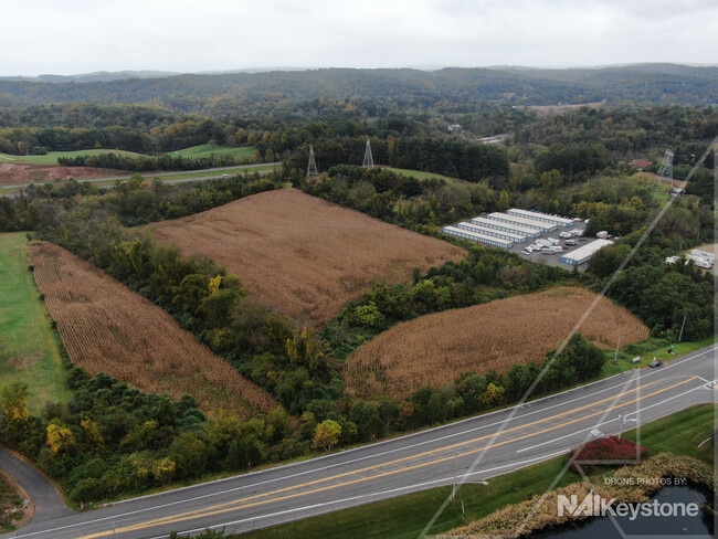
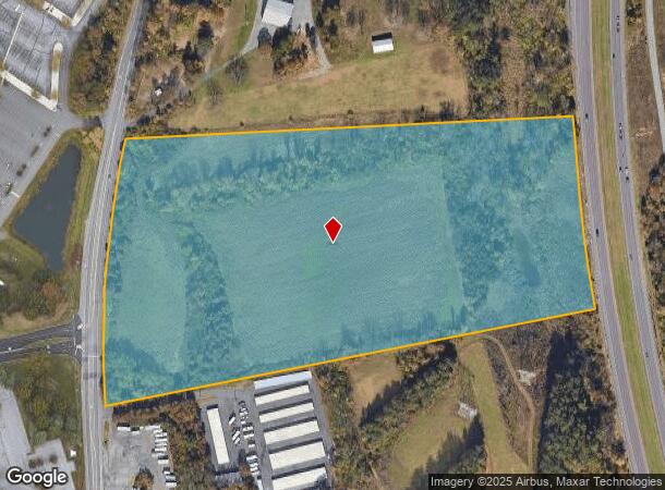
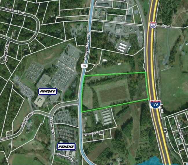
Morgantown Rd
39-5314-03-14-0411
Berks
Recreationalacreage
Pennsylvania
X
18.85 AC
42011C0518G
Berks County
2025
Philadelphia
2025
Reading, PA
011602
DEMOGRAPHICS near Morgantown Rd
1 Mile
3 Mile
5 Mile
2024 Total Population
1,168
11,645
93,457
2029 Population
1,148
11,607
93,934
Pop Growth 2024-2029
(1.71%)
(0.33%)
+ 0.51%
Average Age
48
45
40
2024 Total Households
561
4,951
36,509
HH Growth 2024-2029
(2.14%)
(0.57%)
+ 0.48%
Median Household Inc
$88,109
$92,934
$63,522
Avg Household Size
2.00
2.30
2.40
2024 Avg HH Vehicles
2.00
2.00
2.00
Median Home Value
$267,625
$267,111
$194,553
Median Year Built
1978
1978
1965
Nearby Places
Map Layers
Map Styles
 Street
 Aerial
- Restaurants
- Banks
- Shops
- Fitness
- Groceries
SALE & LEASE HISTORY
LISTING DATE
SALE/LEASE

Oct 13, 2021
For Sale
Jul 14, 2020
For Sale
Jan 19, 2017
For Sale
Aug 26, 2021
For Sale
Nearby Properties
Address
Land Use
TOTAL SIZE
Lot Size
Zoning
Address
Land Use
TOTAL SIZE
Lot Size
Zoning
392,251 SF
78.10 AC
Address
Land Use
TOTAL SIZE
Lot Size
Zoning
241,645 SF
37.72 AC
Address
Land Use
TOTAL SIZE
Lot Size
Zoning
20,731 SF
28.51 AC
Address
Land Use
TOTAL SIZE
Lot Size
Zoning
163,466 SF
19.19 AC
Address
Land Use
TOTAL SIZE
Lot Size
Zoning
129,363 SF
12.14 AC
Address
Land Use
TOTAL SIZE
Lot Size
Zoning
84,599 SF
28.56 AC
Address
Land Use
TOTAL SIZE
Lot Size
Zoning
38,272 SF
16.16 AC
Address
Land Use
TOTAL SIZE
Lot Size
Zoning
135,196 SF
22.41 AC
Address
Land Use
TOTAL SIZE
Lot Size
Zoning
120,390 SF
12.65 AC
Address
Land Use
TOTAL SIZE
Lot Size
Zoning
82,276 SF
11.16 AC
Address
Land Use
TOTAL SIZE
Lot Size
Zoning
84,337 SF
11.20 AC
Address
Land Use
TOTAL SIZE
Lot Size
Zoning
14,700 SF
6.04 AC
Address
Land Use
TOTAL SIZE
Lot Size
Zoning
8,640 SF
182.40 AC
Address
Land Use
TOTAL SIZE
Lot Size
Zoning
41,112 SF
1.16 AC
Address
Land Use
TOTAL SIZE
Lot Size
Zoning
65,353 SF
23.73 AC
Address
Land Use
TOTAL SIZE
Lot Size
Zoning
28,140 SF
208.09 AC
Address
Land Use
TOTAL SIZE
Lot Size
Zoning
35,982 SF
1.16 AC
Address
Land Use
TOTAL SIZE
Lot Size
Zoning
30,929 SF
2.54 AC
Address
Land Use
TOTAL SIZE
Lot Size
Zoning
11,194 SF
100.83 AC
Address
Land Use
TOTAL SIZE
Lot Size
Zoning
93,482 SF
13.94 AC
Address
Land Use
TOTAL SIZE
Lot Size
Zoning
30,492 SF
0.39 AC
Address
Land Use
TOTAL SIZE
Lot Size
Zoning
39,400 SF
5.31 AC
Address
Land Use
TOTAL SIZE
Lot Size
Zoning
19,320 SF
4.24 AC
Address
Land Use
TOTAL SIZE
Lot Size
Zoning
22,505 SF
0.71 AC
Address
Land Use
TOTAL SIZE
Lot Size
Zoning
22,908 SF
0.75 AC
Address
Land Use
TOTAL SIZE
Lot Size
Zoning
22,892 SF
81.73 AC
Address
Land Use
TOTAL SIZE
Lot Size
Zoning
35,391 SF
14.47 AC
Address
Land Use
TOTAL SIZE
Lot Size
Zoning
23,146 SF
1.56 AC
Address
Land Use
TOTAL SIZE
Lot Size
Zoning
6,120 SF
5.01 AC
Address
Land Use
TOTAL SIZE
Lot Size
Zoning
18,876 SF
2.30 AC
The World's #1 Commercial Real Estate Marketplace
Connect with us
© 2025 CoStar Group
The information above has been obtained from sources believed reliable. While we do not doubt its accuracy we have not verified it and make no guarantee, warranty or representation about it. It is your responsibility to independently confirm its accuracy and completeness. Any projections, opinions, assumptions, or estimates used are for example only and do not represent the current or future performance of the property. The value of this transaction to you depends on tax and other factors which should be evaluated by your tax, financial, and legal advisors. You and your advisors should conduct a careful, independent investigation of the property to determine to your satisfaction the suitability of the property for your needs.