Property Record
Morning Dr, 29 Palms, CA 92277
Property Detail
Morning Dr
Riverside-San Bernardino-Ontario, CA
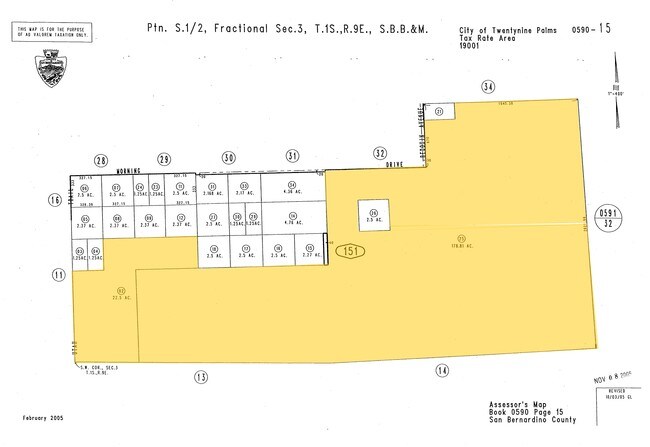
N 1/2 NE 1/4 SW 1/4 SW 1/4 AND W 1/2 SW 1/4 SW 1/4 SEC 3 TP 1S R 9E EX NW 1/4 NW 1/4 SW 1/4 SW 1/4 OF W 1/2 SW 1/4 SW 1/4 22.50 AC M/L
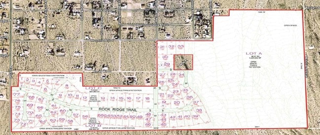
0590-151-25
SAN BERNARDINO
Vacantlandnec
California
AO River or stream flood hazard areas, and areas with a 1% or greater chance of shallow flooding each year. These areas have a 26% chance of flooding over the life of a 30-year mortgage.
178.81 AC
2025
Twentynine Palms
2025
Inland Empire (California)
010422
NEARBY LISTINGS FOR SALE OR LEASE
DEMOGRAPHICS near Morning Dr
1 mile
3 mile
5 mile
2025 Total Population
1,021
8,145
17,009
2030 Population
1,066
8,508
17,687
Pop Growth 2025-2030
+ 4.41%
+ 4.46%
+ 3.99%
Average Age
38
34
36
2025 Total Households
427
3,486
6,978
HH Growth 2025-2030
+ 4.22%
+ 4.42%
+ 3.98%
Median Household Inc
$70,471
$49,097
$58,242
Avg Household Size
2.40
2.30
2.40
2025 Avg HH Vehicles
2.00
2.00
2.00
Median Home Value
$211,628
$277,300
$294,684
Median Year Built
1980
1989
1985
Nearby Places
Map Layers
Map Styles
 Street
 Aerial
Layers
 Traffic
 Biking
Places
Listings with unknown addresses are not visible on the map
- Restaurants
- Banks
- Shops
- Fitness
- Groceries
Nearby Properties
Address
Land Use
TOTAL SIZE
Lot Size
Zoning
Address
Land Use
TOTAL SIZE
Lot Size
Zoning
448,671 SF
65.68 AC
Address
Land Use
TOTAL SIZE
Lot Size
Zoning
252,350 SF
29.43 AC
Address
Land Use
TOTAL SIZE
Lot Size
Zoning
24,425 SF
1.22 AC
Address
Land Use
TOTAL SIZE
Lot Size
Zoning
45,360 SF
4.23 AC
Address
Land Use
TOTAL SIZE
Lot Size
Zoning
18,072 SF
1.38 AC
Address
Land Use
TOTAL SIZE
Lot Size
Zoning
2,000 SF
0.23 AC
Address
Land Use
TOTAL SIZE
Lot Size
Zoning
45,226 SF
6.71 AC
Address
Land Use
TOTAL SIZE
Lot Size
Zoning
9,370 SF
0.81 AC
Address
Land Use
TOTAL SIZE
Lot Size
Zoning
9,187 SF
31.13 AC
Address
Land Use
TOTAL SIZE
Lot Size
Zoning
13,050 SF
15.10 AC
Address
Land Use
TOTAL SIZE
Lot Size
Zoning
3,146 SF
1.16 AC
Address
Land Use
TOTAL SIZE
Lot Size
Zoning
4,272 SF
0.93 AC
Address
Land Use
TOTAL SIZE
Lot Size
Zoning
4,980 SF
0.75 AC
Address
Land Use
TOTAL SIZE
Lot Size
Zoning
3,551 SF
11.70 AC
Address
Land Use
TOTAL SIZE
Lot Size
Zoning
4,054 SF
0.51 AC
Address
Land Use
TOTAL SIZE
Lot Size
Zoning
2,880 SF
0.79 AC
Address
Land Use
TOTAL SIZE
Lot Size
Zoning
18,544 SF
9.03 AC
Address
Land Use
TOTAL SIZE
Lot Size
Zoning
2,624 SF
0.76 AC
Address
Land Use
TOTAL SIZE
Lot Size
Zoning
4,000 SF
0.15 AC
Address
Land Use
TOTAL SIZE
Lot Size
Zoning
6,020 SF
3.45 AC
Address
Land Use
TOTAL SIZE
Lot Size
Zoning
6,777 SF
0.36 AC
Address
Land Use
TOTAL SIZE
Lot Size
Zoning
5,880 SF
0.83 AC
Address
Land Use
TOTAL SIZE
Lot Size
Zoning
4,704 SF
1.42 AC
Address
Land Use
TOTAL SIZE
Lot Size
Zoning
7,021 SF
2.72 AC
Address
Land Use
TOTAL SIZE
Lot Size
Zoning
5,000 SF
0.82 AC
Address
Land Use
TOTAL SIZE
Lot Size
Zoning
8,578 SF
1.65 AC
Address
Land Use
TOTAL SIZE
Lot Size
Zoning
17,511 SF
0.19 AC
Address
Land Use
TOTAL SIZE
Lot Size
Zoning
2,808 SF
12.74 AC
Address
Land Use
TOTAL SIZE
Lot Size
Zoning
980 SF
1.01 AC
Address
Land Use
TOTAL SIZE
Lot Size
Zoning
5,748 SF
0.94 AC
The World's #1 Commercial Real Estate Marketplace
Connect with us
© 2026 CoStar Group
The information above has been obtained from sources believed reliable. While we do not doubt its accuracy we have not verified it and make no guarantee, warranty or representation about it. It is your responsibility to independently confirm its accuracy and completeness. Any projections, opinions, assumptions, or estimates used are for example only and do not represent the current or future performance of the property. The value of this transaction to you depends on tax and other factors which should be evaluated by your tax, financial, and legal advisors. You and your advisors should conduct a careful, independent investigation of the property to determine to your satisfaction the suitability of the property for your needs.