Property Record
Motor World Dr, , PA
Save to a Folder
{{folder.Name}}
{{folder.ListingIds.length}} Properties
{{folder.ListingIds.length}} Property
Create a New Folder
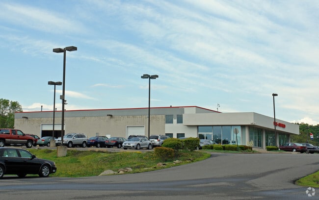
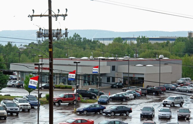
Property Detail
Motor World Dr
Scranton--Wilkes-Barre, PA
MOTORWORLD DR
73-H10NE2-11A-001-000
LUZERNE
Vehiclerentalsvehiclesales
Pennsylvania
A Areas with a 1% annual chance of flooding and a 26% chance of flooding over the life of a 30-year mortgage.
1
2026
55.45 AC
2026
I-81 Corridor
212700
Philadelphia
3,990 SF
NEARBY LISTINGS FOR SALE OR LEASE
DEMOGRAPHICS near Motor World Dr
1 mile
3 mile
5 mile
2025 Total Population
5,426
53,446
120,948
2030 Population
5,476
54,150
122,776
Pop Growth 2025-2030
+ 0.92%
+ 1.32%
+ 1.51%
Average Age
44
41
41
2025 Total Households
2,313
22,047
51,745
HH Growth 2025-2030
+ 0.86%
+ 1.27%
+ 1.50%
Median Household Inc
$50,405
$52,187
$56,064
Avg Household Size
2.20
2.10
2.20
2025 Avg HH Vehicles
2.00
1.00
2.00
Median Home Value
$139,805
$149,845
$151,396
Median Year Built
1953
1950
1951
Nearby Places
Map Layers
Map Styles
 Street
 Aerial
Layers
 Traffic
 Biking
Places
Listings with unknown addresses are not visible on the map
- Restaurants
- Banks
- Shops
- Fitness
- Groceries
PUBLIC TRANSPORTATION
AIRPORT
Wilkes-Barre/Scranton International
Drive
Walk
Distance
Wilkes-Barre/Scranton International
18 min
9.1 mi
Freight Ports
Maher Terminal
Drive
Walk
Distance
Maher Terminal
152 min
118.5 mi
Nearby Properties
Address
Land Use
TOTAL SIZE
Lot Size
Zoning
Address
Land Use
TOTAL SIZE
Lot Size
Zoning
1,500,000 SF
29.42 AC
Address
Land Use
TOTAL SIZE
Lot Size
Zoning
263.92 AC
Address
Land Use
TOTAL SIZE
Lot Size
Zoning
Address
Land Use
TOTAL SIZE
Lot Size
Zoning
50.81 AC
Address
Land Use
TOTAL SIZE
Lot Size
Zoning
132.36 AC
Address
Land Use
TOTAL SIZE
Lot Size
Zoning
46.26 AC
Address
Land Use
TOTAL SIZE
Lot Size
Zoning
44.09 AC
Address
Land Use
TOTAL SIZE
Lot Size
Zoning
868,000 SF
81.81 AC
Address
Land Use
TOTAL SIZE
Lot Size
Zoning
Address
Land Use
TOTAL SIZE
Lot Size
Zoning
4.08 AC
Address
Land Use
TOTAL SIZE
Lot Size
Zoning
243,826 SF
30.02 AC
Address
Land Use
TOTAL SIZE
Lot Size
Zoning
158,180 SF
3.86 AC
Address
Land Use
TOTAL SIZE
Lot Size
Zoning
18,650 SF
37.94 AC
Address
Land Use
TOTAL SIZE
Lot Size
Zoning
12.25 AC
Address
Land Use
TOTAL SIZE
Lot Size
Zoning
Address
Land Use
TOTAL SIZE
Lot Size
Zoning
116,284 SF
4.48 AC
Address
Land Use
TOTAL SIZE
Lot Size
Zoning
197,313 SF
14.33 AC
Address
Land Use
TOTAL SIZE
Lot Size
Zoning
25,896 SF
6.50 AC
Address
Land Use
TOTAL SIZE
Lot Size
Zoning
21.24 AC
Address
Land Use
TOTAL SIZE
Lot Size
Zoning
Address
Land Use
TOTAL SIZE
Lot Size
Zoning
139,040 SF
Address
Land Use
TOTAL SIZE
Lot Size
Zoning
77.69 AC
Address
Land Use
TOTAL SIZE
Lot Size
Zoning
63,120 SF
1.36 AC
Address
Land Use
TOTAL SIZE
Lot Size
Zoning
43.01 AC
Address
Land Use
TOTAL SIZE
Lot Size
Zoning
7,200 SF
12.60 AC
Address
Land Use
TOTAL SIZE
Lot Size
Zoning
16.96 AC
Address
Land Use
TOTAL SIZE
Lot Size
Zoning
Address
Land Use
TOTAL SIZE
Lot Size
Zoning
4.38 AC
Address
Land Use
TOTAL SIZE
Lot Size
Zoning
9.15 AC
The World's #1 Commercial Real Estate Marketplace
Connect with us
© 2026 CoStar Group
The information above has been obtained from sources believed reliable. While we do not doubt its accuracy we have not verified it and make no guarantee, warranty or representation about it. It is your responsibility to independently confirm its accuracy and completeness. Any projections, opinions, assumptions, or estimates used are for example only and do not represent the current or future performance of the property. The value of this transaction to you depends on tax and other factors which should be evaluated by your tax, financial, and legal advisors. You and your advisors should conduct a careful, independent investigation of the property to determine to your satisfaction the suitability of the property for your needs.