Property Record
Mountain Rd, Milton, GA 30004
Save to a Folder
{{folder.Name}}
{{folder.ListingIds.length}} Properties
{{folder.ListingIds.length}} Property
Create a New Folder
Property Detail
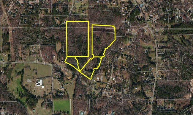
Mountain Rd
22-5000-0247-059-2
FULTON
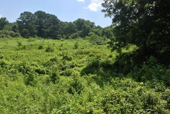
Residentialacreage
Georgia
AG1
7.57 AC
B and X Area of moderate flood hazard, usually the area between the limits of the 100-year and 500-year floods.
N Fulton/Forsyth County
2025
Atlanta
2025
Atlanta-Sandy Springs-Roswell, GA
011661
NEARBY LISTINGS FOR SALE OR LEASE
DEMOGRAPHICS near Mountain Rd
1 mile
3 mile
5 mile
2025 Total Population
1,934
22,159
77,079
2030 Population
2,040
23,602
82,517
Pop Growth 2025-2030
+ 5.48%
+ 6.51%
+ 7.06%
Average Age
43
41
39
2025 Total Households
657
7,206
24,735
HH Growth 2025-2030
+ 5.63%
+ 6.54%
+ 7.10%
Median Household Inc
$203,284
$174,394
$165,918
Avg Household Size
2.90
3.00
3.10
2025 Avg HH Vehicles
2.00
2.00
2.00
Median Home Value
$836,290
$762,664
$714,323
Median Year Built
2004
2002
2004
Nearby Places
Map Layers
Map Styles
 Street
 Aerial
Layers
 Traffic
 Biking
Places
Listings with unknown addresses are not visible on the map
- Restaurants
- Banks
- Shops
- Fitness
- Groceries
SALE & LEASE HISTORY
LISTING DATE
SALE/LEASE

Sep 24, 2016
For Sale
Nearby Properties
Address
Land Use
TOTAL SIZE
Lot Size
Zoning
Address
Land Use
TOTAL SIZE
Lot Size
Zoning
55.36 AC
AG1
Address
Land Use
TOTAL SIZE
Lot Size
Zoning
225,176 SF
24.55 AC
CBD
Address
Land Use
TOTAL SIZE
Lot Size
Zoning
105,243 SF
2.99 AC
CBD
Address
Land Use
TOTAL SIZE
Lot Size
Zoning
28.79 AC
AG1
Address
Land Use
TOTAL SIZE
Lot Size
Zoning
84,461 SF
19.52 AC
AG1
Address
Land Use
TOTAL SIZE
Lot Size
Zoning
19.70 AC
AG1
Address
Land Use
TOTAL SIZE
Lot Size
Zoning
23.15 AC
AG1
Address
Land Use
TOTAL SIZE
Lot Size
Zoning
4,981 SF
172.81 AC
AG1
Address
Land Use
TOTAL SIZE
Lot Size
Zoning
61,821 SF
13.16 AC
CBD
Address
Land Use
TOTAL SIZE
Lot Size
Zoning
260,080 SF
34.88 AC
M1
Address
Land Use
TOTAL SIZE
Lot Size
Zoning
24.04 AC
AG1
Address
Land Use
TOTAL SIZE
Lot Size
Zoning
19.18 AC
AG1
Address
Land Use
TOTAL SIZE
Lot Size
Zoning
3.50 AC
M1
Address
Land Use
TOTAL SIZE
Lot Size
Zoning
14.67 AC
AG1
Address
Land Use
TOTAL SIZE
Lot Size
Zoning
29,692 SF
4.18 AC
CBD
Address
Land Use
TOTAL SIZE
Lot Size
Zoning
45,929 SF
4.40 AC
CBD
Address
Land Use
TOTAL SIZE
Lot Size
Zoning
13,764 SF
16.80 AC
AG1
Address
Land Use
TOTAL SIZE
Lot Size
Zoning
12.45 AC
AG1
Address
Land Use
TOTAL SIZE
Lot Size
Zoning
6,773 SF
1.06 AC
AG1
Address
Land Use
TOTAL SIZE
Lot Size
Zoning
22,337 SF
3.14 AC
CBD
Address
Land Use
TOTAL SIZE
Lot Size
Zoning
37,816 SF
3.58 AC
M1
Address
Land Use
TOTAL SIZE
Lot Size
Zoning
24.82 AC
AG1
Address
Land Use
TOTAL SIZE
Lot Size
Zoning
49,276 SF
8.60 AC
M2
Address
Land Use
TOTAL SIZE
Lot Size
Zoning
12,988 SF
199.89 AC
AG
Address
Land Use
TOTAL SIZE
Lot Size
Zoning
1,231 SF
10.63 AC
AG1
Address
Land Use
TOTAL SIZE
Lot Size
Zoning
10 AC
AG1
Address
Land Use
TOTAL SIZE
Lot Size
Zoning
29,040 SF
2.20 AC
M1
Address
Land Use
TOTAL SIZE
Lot Size
Zoning
50,267 SF
10.07 AC
R1
Address
Land Use
TOTAL SIZE
Lot Size
Zoning
41,446 SF
15.48 AC
R1
Address
Land Use
TOTAL SIZE
Lot Size
Zoning
35,072 SF
5.30 AC
M2
The World's #1 Commercial Real Estate Marketplace
Connect with us
© 2026 CoStar Group
The information above has been obtained from sources believed reliable. While we do not doubt its accuracy we have not verified it and make no guarantee, warranty or representation about it. It is your responsibility to independently confirm its accuracy and completeness. Any projections, opinions, assumptions, or estimates used are for example only and do not represent the current or future performance of the property. The value of this transaction to you depends on tax and other factors which should be evaluated by your tax, financial, and legal advisors. You and your advisors should conduct a careful, independent investigation of the property to determine to your satisfaction the suitability of the property for your needs.