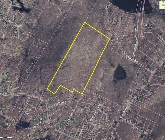
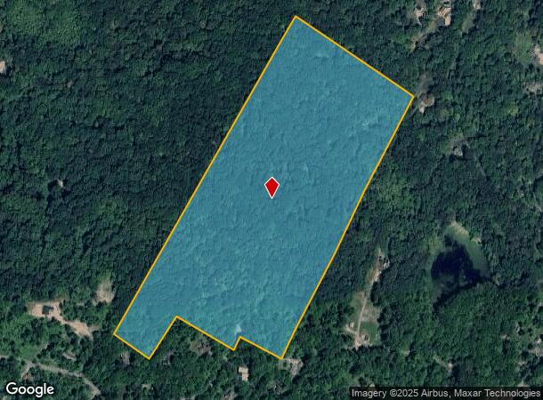
Property Record
Mt Airy Rd W, Cortlandt Manor, NY 10567
NEARBY LISTINGS FOR SALE OR LEASE
Property Detail
Mt Airy Rd W
New York-Jersey City-White Plains, NY-NJ
21.00-002-015
2289-056-017-00001-000-0018
Westchester
Residentialacreage
New York
X
18.000
36119C0126F
48.66 AC
2025
Northwest
2024
Westchester/So Connecticut
014701
DEMOGRAPHICS near Mt Airy Rd W
1 Mile
3 Mile
5 Mile
2024 Total Population
1,137
19,637
75,826
2029 Population
1,117
19,302
73,663
Pop Growth 2024-2029
(1.76%)
(1.71%)
(2.85%)
Average Age
46
46
43
2024 Total Households
447
7,272
27,766
HH Growth 2024-2029
(2.24%)
(2.12%)
(3.08%)
Median Household Inc
$195,832
$156,250
$114,764
Avg Household Size
2.50
2.50
2.60
2024 Avg HH Vehicles
2.00
2.00
2.00
Median Home Value
$742,187
$693,341
$488,179
Median Year Built
1972
1966
1962
Nearby Places
- Restaurants
- Banks
- Shops
- Fitness
- Groceries
PUBLIC TRANSPORTATION
COMMUTER RAIL
Croton-Harmon Station (Hudson Line - Metro-North Commuter Railroad Company (Metro-North))
DRIVE
WALK
Distance
Croton-Harmon Station (Hudson Line - Metro-North Commuter Railroad Company (Metro-North))
12 min
3.9 mi
Cortlandt Station (Hudson Line - Metro-North Commuter Railroad Company (Metro-North))
DRIVE
WALK
Distance
Cortlandt Station (Hudson Line - Metro-North Commuter Railroad Company (Metro-North))
13 min
4.6 mi
AIRPORT
Westchester County
DRIVE
WALK
Distance
Westchester County
40 min
21.9 mi
New York Stewart International
DRIVE
WALK
Distance
New York Stewart International
57 min
31.4 mi
Freight Ports
NY - Red Hook Container Terminal
DRIVE
WALK
Distance
NY - Red Hook Container Terminal
79 min
49.5 mi
SALE & LEASE HISTORY
LISTING DATE
SALE/LEASE

Oct 23, 2017
For Sale
Nearby Properties
Address
Land Use
TOTAL SIZE
Lot Size
Zoning
Address
Land Use
TOTAL SIZE
Lot Size
Zoning
188.01 AC
Address
Land Use
TOTAL SIZE
Lot Size
Zoning
26.50 AC
Address
Land Use
TOTAL SIZE
Lot Size
Zoning
0.80 AC
Address
Land Use
TOTAL SIZE
Lot Size
Zoning
Address
Land Use
TOTAL SIZE
Lot Size
Zoning
180 SF
33.28 AC
R-2A
Address
Land Use
TOTAL SIZE
Lot Size
Zoning
1,616 SF
2.79 AC
Address
Land Use
TOTAL SIZE
Lot Size
Zoning
Address
Land Use
TOTAL SIZE
Lot Size
Zoning
13.80 AC
Address
Land Use
TOTAL SIZE
Lot Size
Zoning
Address
Land Use
TOTAL SIZE
Lot Size
Zoning
Address
Land Use
TOTAL SIZE
Lot Size
Zoning
5.75 AC
Address
Land Use
TOTAL SIZE
Lot Size
Zoning
Address
Land Use
TOTAL SIZE
Lot Size
Zoning
4,312 SF
1.53 AC
R-2A
Address
Land Use
TOTAL SIZE
Lot Size
Zoning
2,976 SF
6 AC
R-2A
Address
Land Use
TOTAL SIZE
Lot Size
Zoning
6,100 SF
3.75 AC
R-2A
Address
Land Use
TOTAL SIZE
Lot Size
Zoning
Address
Land Use
TOTAL SIZE
Lot Size
Zoning
22.50 AC
Address
Land Use
TOTAL SIZE
Lot Size
Zoning
Address
Land Use
TOTAL SIZE
Lot Size
Zoning
Address
Land Use
TOTAL SIZE
Lot Size
Zoning
0.92 AC
Address
Land Use
TOTAL SIZE
Lot Size
Zoning
Address
Land Use
TOTAL SIZE
Lot Size
Zoning
Address
Land Use
TOTAL SIZE
Lot Size
Zoning
3,263 SF
4.94 AC
R-2A
Address
Land Use
TOTAL SIZE
Lot Size
Zoning
Address
Land Use
TOTAL SIZE
Lot Size
Zoning
3,902 SF
2.90 AC
R-2A
Address
Land Use
TOTAL SIZE
Lot Size
Zoning
12.50 AC
Address
Land Use
TOTAL SIZE
Lot Size
Zoning
3,233 SF
3.92 AC
R-2A
Address
Land Use
TOTAL SIZE
Lot Size
Zoning
Address
Land Use
TOTAL SIZE
Lot Size
Zoning
4.10 AC
Address
Land Use
TOTAL SIZE
Lot Size
Zoning
The World's #1 Commercial Real Estate Marketplace
Connect with us
© 2025 CoStar Group
The information above has been obtained from sources believed reliable. While we do not doubt its accuracy we have not verified it and make no guarantee, warranty or representation about it. It is your responsibility to independently confirm its accuracy and completeness. Any projections, opinions, assumptions, or estimates used are for example only and do not represent the current or future performance of the property. The value of this transaction to you depends on tax and other factors which should be evaluated by your tax, financial, and legal advisors. You and your advisors should conduct a careful, independent investigation of the property to determine to your satisfaction the suitability of the property for your needs.