Property Record
Mt Everest Ln, , MD
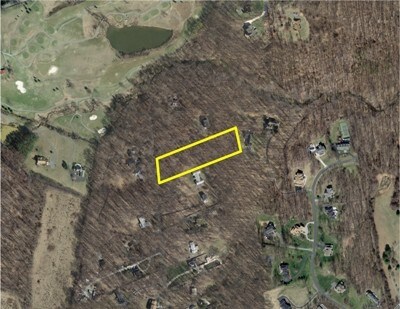

Property Detail
Mt Everest Ln
08-00718987
BRADFORDS REST ITEM NO 89299
Vacantlandnec
MONTGOMERY
RE2
Maryland
B and X Area of moderate flood hazard, usually the area between the limits of the 100-year and 500-year floods.
2.63 AC
2024
Outlying Montgmery Cnty E
2025
Washington, DC
701308
Washington-Arlington-Alexandria, DC-VA-MD-WV
NEARBY LISTINGS FOR SALE OR LEASE
DEMOGRAPHICS near Mt Everest Ln
1 mile
3 mile
5 mile
2024 Total Population
6,516
79,911
195,675
2029 Population
6,472
79,043
192,818
Pop Growth 2024-2029
(0.68%)
(1.09%)
(1.46%)
Average Age
50
44
42
2024 Total Households
2,852
30,045
65,810
HH Growth 2024-2029
(1.26%)
(1.12%)
(1.54%)
Median Household Inc
$107,436
$100,523
$108,690
Avg Household Size
2.30
2.60
2.80
2024 Avg HH Vehicles
2.00
2.00
2.00
Median Home Value
$414,389
$492,809
$488,171
Median Year Built
1991
1982
1975
Nearby Places
Map Layers
Map Styles
 Street
 Aerial
Transit
 Traffic
 Biking
Places
Listings with unknown addresses are not visible on the map
- Restaurants
- Banks
- Shops
- Fitness
- Groceries
PUBLIC TRANSPORTATION
COMMUTER RAIL
Rockville (Brunswick Line - Maryland Area Regional Commuter Trains (The MARC))
Drive
Walk
Distance
Rockville (Brunswick Line - Maryland Area Regional Commuter Trains (The MARC))
12 min
6.0 mi
Drive
Walk
Distance
16 min
7.6 mi
AIRPORT
Ronald Reagan Washington Ntl
Drive
Walk
Distance
Ronald Reagan Washington Ntl
42 min
21.2 mi
Baltimore/Washington International Thurgood Marshall
Drive
Walk
Distance
Baltimore/Washington International Thurgood Marshall
43 min
31.1 mi
Washington Dulles International
Drive
Walk
Distance
Washington Dulles International
57 min
33.5 mi
Freight Ports
Port of Baltimore
Drive
Walk
Distance
Port of Baltimore
47 min
33.7 mi
SALE & LEASE HISTORY
LISTING DATE
SALE/LEASE

Nov 13, 2017
For Sale
Nearby Properties
Address
Land Use
TOTAL SIZE
Lot Size
Zoning
Address
Land Use
TOTAL SIZE
Lot Size
Zoning
643,335 SF
29.18 AC
R20
Address
Land Use
TOTAL SIZE
Lot Size
Zoning
515,740 SF
19.97 AC
R20
Address
Land Use
TOTAL SIZE
Lot Size
Zoning
233,735 SF
21.74 AC
RE2
Address
Land Use
TOTAL SIZE
Lot Size
Zoning
202,044 SF
17.69 AC
CRT2.
Address
Land Use
TOTAL SIZE
Lot Size
Zoning
258,000 SF
6.34 AC
PRC
Address
Land Use
TOTAL SIZE
Lot Size
Zoning
251,862 SF
91.09 AC
RE2C
Address
Land Use
TOTAL SIZE
Lot Size
Zoning
131,521 SF
13.40 AC
PRC
Address
Land Use
TOTAL SIZE
Lot Size
Zoning
235,762 SF
139.24 AC
RE2
Address
Land Use
TOTAL SIZE
Lot Size
Zoning
294,082 SF
12.18 AC
R20
Address
Land Use
TOTAL SIZE
Lot Size
Zoning
425,295 SF
15.72 AC
CRT22
Address
Land Use
TOTAL SIZE
Lot Size
Zoning
289,712 SF
19.79 AC
RNC
Address
Land Use
TOTAL SIZE
Lot Size
Zoning
135,878 SF
17.11 AC
RNC
Address
Land Use
TOTAL SIZE
Lot Size
Zoning
165,842 SF
16.90 AC
RE2
Address
Land Use
TOTAL SIZE
Lot Size
Zoning
209,897 SF
48.45 AC
RC
Address
Land Use
TOTAL SIZE
Lot Size
Zoning
262,984 SF
7.58 AC
R20
Address
Land Use
TOTAL SIZE
Lot Size
Zoning
188,160 SF
7.42 AC
R20
Address
Land Use
TOTAL SIZE
Lot Size
Zoning
96,941 SF
10.87 AC
CRT2.
Address
Land Use
TOTAL SIZE
Lot Size
Zoning
118,204 SF
8.62 AC
NR0.7
Address
Land Use
TOTAL SIZE
Lot Size
Zoning
140,080 SF
6.48 AC
PD9
Address
Land Use
TOTAL SIZE
Lot Size
Zoning
255,986 SF
9.37 AC
R20
Address
Land Use
TOTAL SIZE
Lot Size
Zoning
120,205 SF
19.90 AC
RE2
Address
Land Use
TOTAL SIZE
Lot Size
Zoning
229,669 SF
9.25 AC
R200
Address
Land Use
TOTAL SIZE
Lot Size
Zoning
102,198 SF
7.21 AC
R200
Address
Land Use
TOTAL SIZE
Lot Size
Zoning
194,736 SF
9.33 AC
R20
Address
Land Use
TOTAL SIZE
Lot Size
Zoning
136,736 SF
37.37 AC
RNC
Address
Land Use
TOTAL SIZE
Lot Size
Zoning
206,352 SF
5.61 AC
R20
Address
Land Use
TOTAL SIZE
Lot Size
Zoning
61,578 SF
4.80 AC
RE2
Address
Land Use
TOTAL SIZE
Lot Size
Zoning
262,288 SF
9.70 AC
R20
Address
Land Use
TOTAL SIZE
Lot Size
Zoning
115,000 SF
15.85 AC
RE2
Address
Land Use
TOTAL SIZE
Lot Size
Zoning
55,367 SF
5.41 AC
R200
The World's #1 Commercial Real Estate Marketplace
Connect with us
© 2026 CoStar Group
The information above has been obtained from sources believed reliable. While we do not doubt its accuracy we have not verified it and make no guarantee, warranty or representation about it. It is your responsibility to independently confirm its accuracy and completeness. Any projections, opinions, assumptions, or estimates used are for example only and do not represent the current or future performance of the property. The value of this transaction to you depends on tax and other factors which should be evaluated by your tax, financial, and legal advisors. You and your advisors should conduct a careful, independent investigation of the property to determine to your satisfaction the suitability of the property for your needs.