Property Record
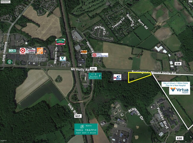
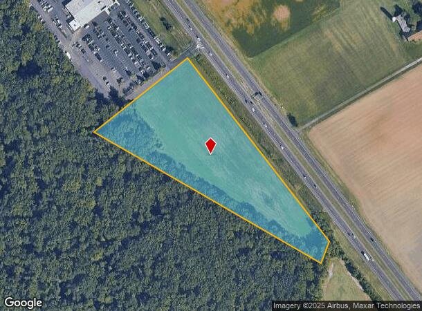
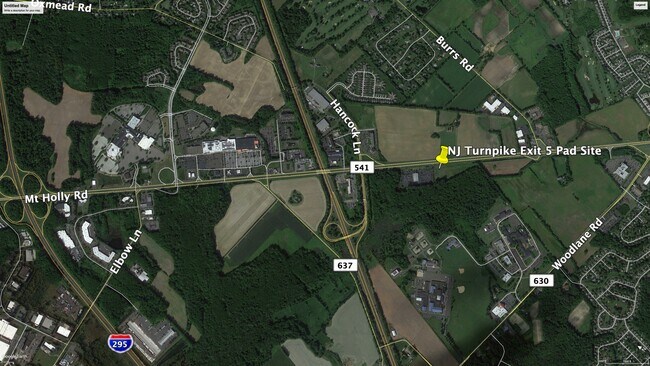
Mt Holly-Burlington Rd, Westampton, NJ 08060
NEARBY LISTINGS FOR SALE OR LEASE
Property Detail
Mt Holly-Burlington Rd
37-00804-0000-00016-01
Burlington
Farms
New Jersey
X
16.1
34005C0139F
7.55 AC
2024
South Burlington County
2025
Philadelphia
702601
Philadelphia-Camden-Wilmington, PA-NJ-DE-MD
DEMOGRAPHICS near Mt Holly-Burlington Rd
1 Mile
3 Mile
5 Mile
2024 Total Population
1,626
36,860
125,091
2029 Population
1,640
37,609
127,486
Pop Growth 2024-2029
+ 0.86%
+ 2.03%
+ 1.91%
Average Age
42
41
42
2024 Total Households
571
13,571
47,023
HH Growth 2024-2029
+ 0.88%
+ 2.20%
+ 1.99%
Median Household Inc
$127,257
$95,737
$91,339
Avg Household Size
2.80
2.60
2.60
2024 Avg HH Vehicles
2.00
2.00
2.00
Median Home Value
$321,939
$266,118
$263,931
Median Year Built
1984
1974
1974
Nearby Places
Map Layers
Map Styles
 Street
 Aerial
- Restaurants
- Banks
- Shops
- Fitness
- Groceries
PUBLIC TRANSPORTATION
COMMUTER RAIL
Bristol (R7 - Southeastern Pennsylvania Transportation Authority Regional Rail (SEPTA Regional Rail))
DRIVE
WALK
Distance
Bristol (R7 - Southeastern Pennsylvania Transportation Authority Regional Rail (SEPTA Regional Rail))
15 min
8.8 mi
Croydon (R7 - Southeastern Pennsylvania Transportation Authority Regional Rail (SEPTA Regional Rail))
DRIVE
WALK
Distance
Croydon (R7 - Southeastern Pennsylvania Transportation Authority Regional Rail (SEPTA Regional Rail))
16 min
9.3 mi
AIRPORT
Trenton Mercer
DRIVE
WALK
Distance
Trenton Mercer
37 min
25.1 mi
Philadelphia International
DRIVE
WALK
Distance
Philadelphia International
48 min
31.8 mi
Freight Ports
Port of Philadelphia
DRIVE
WALK
Distance
Port of Philadelphia
31 min
21.9 mi
SALE & LEASE HISTORY
LISTING DATE
SALE/LEASE

May 05, 2021
For Lease
Nearby Properties
Address
Land Use
TOTAL SIZE
Lot Size
Zoning
Address
Land Use
TOTAL SIZE
Lot Size
Zoning
3.03 AC
OB
Address
Land Use
TOTAL SIZE
Lot Size
Zoning
2,614 SF
55.41 AC
R40
Address
Land Use
TOTAL SIZE
Lot Size
Zoning
Address
Land Use
TOTAL SIZE
Lot Size
Zoning
86.67 AC
R-5
Address
Land Use
TOTAL SIZE
Lot Size
Zoning
14.82 AC
Address
Land Use
TOTAL SIZE
Lot Size
Zoning
97,993 SF
63.75 AC
Address
Land Use
TOTAL SIZE
Lot Size
Zoning
30.76 AC
R-9
Address
Land Use
TOTAL SIZE
Lot Size
Zoning
26.12 AC
B-2
Address
Land Use
TOTAL SIZE
Lot Size
Zoning
100 AC
R-5
Address
Land Use
TOTAL SIZE
Lot Size
Zoning
19.38 AC
R1
Address
Land Use
TOTAL SIZE
Lot Size
Zoning
58.39 AC
B-2
Address
Land Use
TOTAL SIZE
Lot Size
Zoning
682,707 SF
Address
Land Use
TOTAL SIZE
Lot Size
Zoning
478,715 SF
35.19 AC
Address
Land Use
TOTAL SIZE
Lot Size
Zoning
6.59 AC
GS
Address
Land Use
TOTAL SIZE
Lot Size
Zoning
0.52 AC
GS
Address
Land Use
TOTAL SIZE
Lot Size
Zoning
Address
Land Use
TOTAL SIZE
Lot Size
Zoning
18.77 AC
Address
Land Use
TOTAL SIZE
Lot Size
Zoning
11.82 AC
R-5
Address
Land Use
TOTAL SIZE
Lot Size
Zoning
2,704 SF
28.75 AC
Address
Land Use
TOTAL SIZE
Lot Size
Zoning
15.09 AC
Address
Land Use
TOTAL SIZE
Lot Size
Zoning
308 SF
24.29 AC
BLI1
Address
Land Use
TOTAL SIZE
Lot Size
Zoning
190,000 SF
22.17 AC
Address
Land Use
TOTAL SIZE
Lot Size
Zoning
266,966 SF
39.90 AC
I-1
Address
Land Use
TOTAL SIZE
Lot Size
Zoning
217,986 SF
39.89 AC
I-1
Address
Land Use
TOTAL SIZE
Lot Size
Zoning
12.90 AC
Address
Land Use
TOTAL SIZE
Lot Size
Zoning
20.52 AC
RH
Address
Land Use
TOTAL SIZE
Lot Size
Zoning
302,372 SF
15.05 AC
Address
Land Use
TOTAL SIZE
Lot Size
Zoning
28 AC
B3
Address
Land Use
TOTAL SIZE
Lot Size
Zoning
10.12 AC
Address
Land Use
TOTAL SIZE
Lot Size
Zoning
17.63 AC
R-1
The World's #1 Commercial Real Estate Marketplace
Connect with us
© 2025 CoStar Group
The information above has been obtained from sources believed reliable. While we do not doubt its accuracy we have not verified it and make no guarantee, warranty or representation about it. It is your responsibility to independently confirm its accuracy and completeness. Any projections, opinions, assumptions, or estimates used are for example only and do not represent the current or future performance of the property. The value of this transaction to you depends on tax and other factors which should be evaluated by your tax, financial, and legal advisors. You and your advisors should conduct a careful, independent investigation of the property to determine to your satisfaction the suitability of the property for your needs.