Property Record
Mt Olive Rd, Beaverdam, VA 23015
NEARBY LISTINGS FOR SALE OR LEASE
-
-
View all Beaverdam listings for sale on LoopNet.com
Property Detail
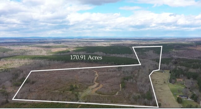
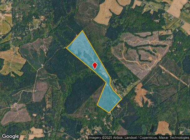
Mt Olive Rd
87-A-8
DR DAVIS
Agriculturalland
Spotsylvania
A
Virginia
51085C0020C
170.91 AC
2025
Spotsylvania County
2025
Washington, DC
320100
Washington-Arlington-Alexandria, DC-VA-MD-WV
DEMOGRAPHICS near Mt Olive Rd
1 Mile
3 Mile
5 Mile
2024 Total Population
109
1,905
7,029
2029 Population
123
2,145
7,945
Pop Growth 2024-2029
+ 12.84%
+ 12.60%
+ 13.03%
Average Age
40
40
41
2024 Total Households
39
655
2,530
HH Growth 2024-2029
+ 12.82%
+ 12.52%
+ 13.28%
Median Household Inc
$55,000
$70,178
$104,682
Avg Household Size
2.70
2.80
2.70
2024 Avg HH Vehicles
2.00
3.00
3.00
Median Home Value
$292,856
$305,866
$334,727
Median Year Built
1994
1993
1995
Nearby Places
Map Layers
Map Styles
 Street
 Aerial
- Restaurants
- Banks
- Shops
- Fitness
- Groceries
SALE & LEASE HISTORY
LISTING DATE
SALE/LEASE

Aug 07, 2024
For Sale
Nearby Properties
Address
Land Use
TOTAL SIZE
Lot Size
Zoning
Address
Land Use
TOTAL SIZE
Lot Size
Zoning
595.58 AC
A3 - AGRIC
Address
Land Use
TOTAL SIZE
Lot Size
Zoning
19.68 AC
RR - RESID
Address
Land Use
TOTAL SIZE
Lot Size
Zoning
968 SF
301.35 AC
A3 - AGRIC
Address
Land Use
TOTAL SIZE
Lot Size
Zoning
24.46 AC
RR - RESID
Address
Land Use
TOTAL SIZE
Lot Size
Zoning
266.60 AC
A3 - AGRIC
Address
Land Use
TOTAL SIZE
Lot Size
Zoning
3,849 SF
82.15 AC
Address
Land Use
TOTAL SIZE
Lot Size
Zoning
1,556 SF
116.62 AC
A3 - AGRIC
Address
Land Use
TOTAL SIZE
Lot Size
Zoning
5,736 SF
23.93 AC
A3 - AGRIC
Address
Land Use
TOTAL SIZE
Lot Size
Zoning
6.20 AC
A3 - AGRIC
Address
Land Use
TOTAL SIZE
Lot Size
Zoning
2,880 SF
27.75 AC
A3 - AGRIC
Address
Land Use
TOTAL SIZE
Lot Size
Zoning
2,524 SF
53.33 AC
A3 - AGRIC
Address
Land Use
TOTAL SIZE
Lot Size
Zoning
2,925 SF
41.82 AC
A3 - AGRIC
Address
Land Use
TOTAL SIZE
Lot Size
Zoning
2,266 SF
75.29 AC
A3 - AGRIC
Address
Land Use
TOTAL SIZE
Lot Size
Zoning
248.37 AC
A3 - AGRIC
Address
Land Use
TOTAL SIZE
Lot Size
Zoning
2,676 SF
133 AC
A3 - AGRIC
Address
Land Use
TOTAL SIZE
Lot Size
Zoning
3,530 SF
48.75 AC
A3 - AGRIC
Address
Land Use
TOTAL SIZE
Lot Size
Zoning
224.50 AC
A3 - AGRIC
Address
Land Use
TOTAL SIZE
Lot Size
Zoning
2,531 SF
128.45 AC
A3 - AGRIC
Address
Land Use
TOTAL SIZE
Lot Size
Zoning
3,468 SF
A3 - AGRIC
Address
Land Use
TOTAL SIZE
Lot Size
Zoning
1,188 SF
247.40 AC
A3 - AGRIC
Address
Land Use
TOTAL SIZE
Lot Size
Zoning
220.40 AC
A3 - AGRIC
Address
Land Use
TOTAL SIZE
Lot Size
Zoning
145.43 AC
A-1
Address
Land Use
TOTAL SIZE
Lot Size
Zoning
1,680 SF
132 AC
A3 - AGRIC
Address
Land Use
TOTAL SIZE
Lot Size
Zoning
218.28 AC
A3 - AGRIC
Address
Land Use
TOTAL SIZE
Lot Size
Zoning
99.56 AC
A-1
Address
Land Use
TOTAL SIZE
Lot Size
Zoning
151 AC
A3 - AGRIC
Address
Land Use
TOTAL SIZE
Lot Size
Zoning
2,756 SF
30.58 AC
A3 - AGRIC
Address
Land Use
TOTAL SIZE
Lot Size
Zoning
2,337 SF
32.43 AC
Address
Land Use
TOTAL SIZE
Lot Size
Zoning
100.50 AC
A-1
Address
Land Use
TOTAL SIZE
Lot Size
Zoning
2,887 SF
37.72 AC
A3 - AGRIC
The World's #1 Commercial Real Estate Marketplace
Connect with us
© 2025 CoStar Group
The information above has been obtained from sources believed reliable. While we do not doubt its accuracy we have not verified it and make no guarantee, warranty or representation about it. It is your responsibility to independently confirm its accuracy and completeness. Any projections, opinions, assumptions, or estimates used are for example only and do not represent the current or future performance of the property. The value of this transaction to you depends on tax and other factors which should be evaluated by your tax, financial, and legal advisors. You and your advisors should conduct a careful, independent investigation of the property to determine to your satisfaction the suitability of the property for your needs.