Property Record
Muddy Ln, Elkton, MD 21921


Save to a Folder
{{folder.Name}}
{{folder.ListingIds.length}} Properties
{{folder.ListingIds.length}} Property
Create a New Folder
Property Detail
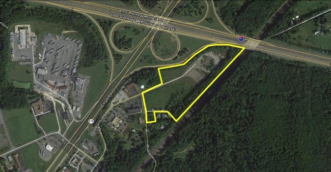
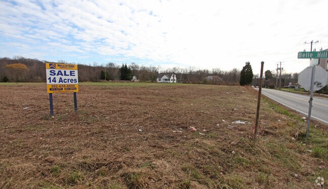
Muddy Ln
03-019217
14.011 AC E/S MUDDY LANE N OF ELKTON
Commercialcondominium
CECIL
C3
Maryland
B and X Area of moderate flood hazard, usually the area between the limits of the 100-year and 500-year floods.
14.01 AC
2024
Cecil County
2025
Baltimore
030503
Philadelphia-Camden-Wilmington, PA-NJ-DE-MD
64,800 SF
NEARBY LISTINGS FOR SALE OR LEASE
DEMOGRAPHICS near Muddy Ln
1 mile
3 mile
5 mile
2025 Total Population
1,694
36,661
106,327
2030 Population
1,683
37,531
110,897
Pop Growth 2025-2030
(0.65%)
+ 2.37%
+ 4.30%
Average Age
37
40
37
2025 Total Households
739
14,349
38,095
HH Growth 2025-2030
(0.68%)
+ 2.40%
+ 4.47%
Median Household Inc
$45,833
$80,948
$81,089
Avg Household Size
2.30
2.50
2.50
2025 Avg HH Vehicles
2.00
2.00
2.00
Median Home Value
$183,928
$336,131
$348,507
Median Year Built
1992
1990
1985
Nearby Places
Map Layers
Map Styles
 Street
 Aerial
Layers
 Traffic
 Biking
Places
Listings with unknown addresses are not visible on the map
- Restaurants
- Banks
- Shops
- Fitness
- Groceries
PUBLIC TRANSPORTATION
COMMUTER RAIL
Newark (R2 - Southeastern Pennsylvania Transportation Authority Regional Rail (SEPTA Regional Rail))
Drive
Walk
Distance
Newark (R2 - Southeastern Pennsylvania Transportation Authority Regional Rail (SEPTA Regional Rail))
8 min
5.4 mi
Churchmans Crossing (R2 - Southeastern Pennsylvania Transportation Authority Regional Rail (SEPTA Regional Rail))
Drive
Walk
Distance
Churchmans Crossing (R2 - Southeastern Pennsylvania Transportation Authority Regional Rail (SEPTA Regional Rail))
15 min
9.9 mi
Freight Ports
Port of Wilmington, RI
Drive
Walk
Distance
Port of Wilmington, RI
24 min
17.7 mi
SALE & LEASE HISTORY
LISTING DATE
SALE/LEASE

Mar 07, 2018
For Sale
Nearby Properties
Address
Land Use
TOTAL SIZE
Lot Size
Zoning
Address
Land Use
TOTAL SIZE
Lot Size
Zoning
383,319 SF
234.70 AC
I
Address
Land Use
TOTAL SIZE
Lot Size
Zoning
756,122 SF
70.18 AC
M1
Address
Land Use
TOTAL SIZE
Lot Size
Zoning
766,520 SF
69.52 AC
BI
Address
Land Use
TOTAL SIZE
Lot Size
Zoning
15,374 SF
15.37 AC
18RH
Address
Land Use
TOTAL SIZE
Lot Size
Zoning
142,774 SF
131.33 AC
M1
Address
Land Use
TOTAL SIZE
Lot Size
Zoning
70,092 SF
41.59 AC
UR
Address
Land Use
TOTAL SIZE
Lot Size
Zoning
193,004 SF
3.67 AC
C1
Address
Land Use
TOTAL SIZE
Lot Size
Zoning
200,880 SF
49.83 AC
R3
Address
Land Use
TOTAL SIZE
Lot Size
Zoning
19.26 AC
RM
Address
Land Use
TOTAL SIZE
Lot Size
Zoning
64,148 SF
31.54 AC
M1
Address
Land Use
TOTAL SIZE
Lot Size
Zoning
560 SF
157.58 AC
18STC
Address
Land Use
TOTAL SIZE
Lot Size
Zoning
138,791 SF
15.19 AC
18STC
Address
Land Use
TOTAL SIZE
Lot Size
Zoning
15,168 SF
7.85 AC
NCAP
Address
Land Use
TOTAL SIZE
Lot Size
Zoning
392,955 SF
16.87 AC
NCAP
Address
Land Use
TOTAL SIZE
Lot Size
Zoning
166,635 SF
50 AC
18STC
Address
Land Use
TOTAL SIZE
Lot Size
Zoning
20,250 SF
71.16 AC
S
Address
Land Use
TOTAL SIZE
Lot Size
Zoning
10,253 SF
8.70 AC
18RM
Address
Land Use
TOTAL SIZE
Lot Size
Zoning
263,500 SF
15.28 AC
BI
Address
Land Use
TOTAL SIZE
Lot Size
Zoning
20,973 SF
75.14 AC
M1
Address
Land Use
TOTAL SIZE
Lot Size
Zoning
294,288 SF
22.25 AC
NCAP
Address
Land Use
TOTAL SIZE
Lot Size
Zoning
81,072 SF
12.86 AC
RM
Address
Land Use
TOTAL SIZE
Lot Size
Zoning
15,215 SF
20.22 AC
18RH
Address
Land Use
TOTAL SIZE
Lot Size
Zoning
124,986 SF
12.40 AC
18MI
Address
Land Use
TOTAL SIZE
Lot Size
Zoning
41,000 SF
32.49 AC
M1
Address
Land Use
TOTAL SIZE
Lot Size
Zoning
82,688 SF
11.30 AC
BI
Address
Land Use
TOTAL SIZE
Lot Size
Zoning
72,725 SF
18.48 AC
18OFD
Address
Land Use
TOTAL SIZE
Lot Size
Zoning
267,840 SF
20.35 AC
BI
Address
Land Use
TOTAL SIZE
Lot Size
Zoning
204,930 SF
9.38 AC
NCAP
Address
Land Use
TOTAL SIZE
Lot Size
Zoning
1,828 SF
10.37 AC
18RM
Address
Land Use
TOTAL SIZE
Lot Size
Zoning
91,879 SF
19.57 AC
18BC
The World's #1 Commercial Real Estate Marketplace
Connect with us
© 2026 CoStar Group
The information above has been obtained from sources believed reliable. While we do not doubt its accuracy we have not verified it and make no guarantee, warranty or representation about it. It is your responsibility to independently confirm its accuracy and completeness. Any projections, opinions, assumptions, or estimates used are for example only and do not represent the current or future performance of the property. The value of this transaction to you depends on tax and other factors which should be evaluated by your tax, financial, and legal advisors. You and your advisors should conduct a careful, independent investigation of the property to determine to your satisfaction the suitability of the property for your needs.