Property Record
1967 Mulberry Rd, Concord, NC 28025
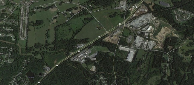

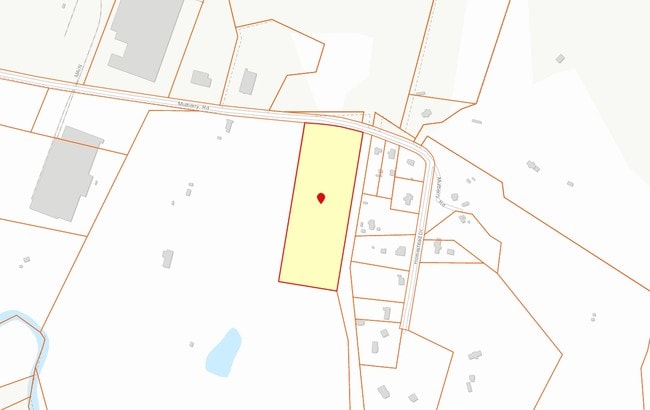
Property Detail
1967 Mulberry Rd
5527-09-1740-0000
S/O MULBERRY RD
Residentialacreage
CABARRUS
O-I
North Carolina
B and X Area of moderate flood hazard, usually the area between the limits of the 100-year and 500-year floods.
10.30 AC
2025
Cabarrus County
2025
Charlotte
042202
Charlotte-Concord-Gastonia, NC-SC
NEARBY LISTINGS FOR SALE OR LEASE
DEMOGRAPHICS near 1967 Mulberry Rd
1 mile
3 mile
5 mile
2025 Total Population
2,622
35,649
88,160
2030 Population
2,792
37,887
94,079
Pop Growth 2025-2030
+ 6.48%
+ 6.28%
+ 6.71%
Average Age
38
38
38
2025 Total Households
866
12,248
30,651
HH Growth 2025-2030
+ 6.58%
+ 6.49%
+ 6.92%
Median Household Inc
$142,636
$107,143
$98,951
Avg Household Size
3.00
2.90
2.80
2025 Avg HH Vehicles
2.00
2.00
2.00
Median Home Value
$454,978
$388,858
$381,339
Median Year Built
2003
2002
2000
Nearby Places
Map Layers
Map Styles
 Street
 Aerial
Layers
 Traffic
 Biking
Places
Listings with unknown addresses are not visible on the map
- Restaurants
- Banks
- Shops
- Fitness
- Groceries
PUBLIC TRANSPORTATION
AIRPORT
Concord-Padgett Regional
Drive
Walk
Distance
Concord-Padgett Regional
21 min
10.9 mi
Charlotte/Douglas International
Drive
Walk
Distance
Charlotte/Douglas International
41 min
25.4 mi
Freight Ports
Port of Wilmington
Drive
Walk
Distance
Port of Wilmington
258 min
199.7 mi
Nearby Properties
Address
Land Use
TOTAL SIZE
Lot Size
Zoning
Address
Land Use
TOTAL SIZE
Lot Size
Zoning
196,893 SF
43.82 AC
MDR
Address
Land Use
TOTAL SIZE
Lot Size
Zoning
226,355 SF
99.26 AC
O-I
Address
Land Use
TOTAL SIZE
Lot Size
Zoning
175,978 SF
63.81 AC
O-I
Address
Land Use
TOTAL SIZE
Lot Size
Zoning
6,539 SF
173.17 AC
LI
Address
Land Use
TOTAL SIZE
Lot Size
Zoning
21,714 SF
15.02 AC
RC
Address
Land Use
TOTAL SIZE
Lot Size
Zoning
35,268 SF
54 AC
PUD
Address
Land Use
TOTAL SIZE
Lot Size
Zoning
152,554 SF
29.94 AC
O-I
Address
Land Use
TOTAL SIZE
Lot Size
Zoning
160,412 SF
39.97 AC
O-I
Address
Land Use
TOTAL SIZE
Lot Size
Zoning
360,400 SF
20.32 AC
EC
Address
Land Use
TOTAL SIZE
Lot Size
Zoning
116,471 SF
24.39 AC
PUD
Address
Land Use
TOTAL SIZE
Lot Size
Zoning
125,245 SF
21.47 AC
O-I
Address
Land Use
TOTAL SIZE
Lot Size
Zoning
304,000 SF
17.30 AC
EC
Address
Land Use
TOTAL SIZE
Lot Size
Zoning
160,357 SF
26.85 AC
O-I
Address
Land Use
TOTAL SIZE
Lot Size
Zoning
8,640 SF
15.51 AC
RC
Address
Land Use
TOTAL SIZE
Lot Size
Zoning
48,888 SF
15.29 AC
GC
Address
Land Use
TOTAL SIZE
Lot Size
Zoning
126,214 SF
93.87 AC
O-I
Address
Land Use
TOTAL SIZE
Lot Size
Zoning
12,486 SF
232.04 AC
O-I
Address
Land Use
TOTAL SIZE
Lot Size
Zoning
174,732 SF
29.05 AC
LI
Address
Land Use
TOTAL SIZE
Lot Size
Zoning
8,656 SF
10.01 AC
RC
Address
Land Use
TOTAL SIZE
Lot Size
Zoning
54,503 SF
9.32 AC
EC
Address
Land Use
TOTAL SIZE
Lot Size
Zoning
12,150 SF
7.23 AC
GI
Address
Land Use
TOTAL SIZE
Lot Size
Zoning
220,121 SF
10.99 AC
I-2
Address
Land Use
TOTAL SIZE
Lot Size
Zoning
21,152 SF
6.03 AC
MDR
Address
Land Use
TOTAL SIZE
Lot Size
Zoning
38,274 SF
15.29 AC
PUD
Address
Land Use
TOTAL SIZE
Lot Size
Zoning
54.02 AC
Address
Land Use
TOTAL SIZE
Lot Size
Zoning
29,725 SF
100.58 AC
I-1
Address
Land Use
TOTAL SIZE
Lot Size
Zoning
86,460 SF
13.73 AC
I-2
Address
Land Use
TOTAL SIZE
Lot Size
Zoning
61,679 SF
5.35 AC
GC
Address
Land Use
TOTAL SIZE
Lot Size
Zoning
11,645 SF
33.30 AC
O-I
Address
Land Use
TOTAL SIZE
Lot Size
Zoning
12,950 SF
7.23 AC
GC
The World's #1 Commercial Real Estate Marketplace
Connect with us
© 2026 CoStar Group
The information above has been obtained from sources believed reliable. While we do not doubt its accuracy we have not verified it and make no guarantee, warranty or representation about it. It is your responsibility to independently confirm its accuracy and completeness. Any projections, opinions, assumptions, or estimates used are for example only and do not represent the current or future performance of the property. The value of this transaction to you depends on tax and other factors which should be evaluated by your tax, financial, and legal advisors. You and your advisors should conduct a careful, independent investigation of the property to determine to your satisfaction the suitability of the property for your needs.