Property Record
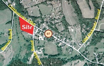
Murkle Rd, Westminster, MD


Property Detail
Murkle Rd
03-021424
LT - 5.520 ACS E/S MURKLE RD UNION MILLS
Residentialacreage
CARROLL
C-1
Maryland
B and X Area of moderate flood hazard, usually the area between the limits of the 100-year and 500-year floods.
5.52 AC
2025
Carroll County
2025
Baltimore
507500
Baltimore-Columbia-Towson, MD
NEARBY LISTINGS FOR SALE OR LEASE
-
-
View all Westminster listings for sale on LoopNet.com
DEMOGRAPHICS near Murkle Rd
1 mile
3 mile
5 mile
2024 Total Population
699
4,119
12,360
2029 Population
709
4,185
12,589
Pop Growth 2024-2029
+ 1.43%
+ 1.60%
+ 1.85%
Average Age
44
44
44
2024 Total Households
259
1,518
4,501
HH Growth 2024-2029
+ 1.54%
+ 1.65%
+ 1.93%
Median Household Inc
$92,187
$98,868
$106,785
Avg Household Size
2.60
2.70
2.70
2024 Avg HH Vehicles
3.00
3.00
3.00
Median Home Value
$419,827
$419,266
$416,405
Median Year Built
1974
1975
1978
Nearby Places
Map Layers
Map Styles
 Street
 Aerial
Transit
 Traffic
 Biking
Places
Listings with unknown addresses are not visible on the map
- Restaurants
- Banks
- Shops
- Fitness
- Groceries
SALE & LEASE HISTORY
LISTING DATE
SALE/LEASE

Jun 16, 2023
For Sale
Feb 03, 2020
For Sale
Nearby Properties
Address
Land Use
TOTAL SIZE
Lot Size
Zoning
Address
Land Use
TOTAL SIZE
Lot Size
Zoning
2,704 SF
70.53 AC
CONSE
Address
Land Use
TOTAL SIZE
Lot Size
Zoning
20,038 SF
12.69 AC
AGRIC
Address
Land Use
TOTAL SIZE
Lot Size
Zoning
13,025 SF
13.75 AC
CONSE
Address
Land Use
TOTAL SIZE
Lot Size
Zoning
4,290 SF
210.81 AC
CONSE
Address
Land Use
TOTAL SIZE
Lot Size
Zoning
9,728 SF
19.17 AC
AGRIC
Address
Land Use
TOTAL SIZE
Lot Size
Zoning
240.59 AC
CONSE
Address
Land Use
TOTAL SIZE
Lot Size
Zoning
7,396 SF
125.92 AC
CONSE
Address
Land Use
TOTAL SIZE
Lot Size
Zoning
113.59 AC
CONSE
Address
Land Use
TOTAL SIZE
Lot Size
Zoning
7,920 SF
121.28 AC
AGRIC
Address
Land Use
TOTAL SIZE
Lot Size
Zoning
101.39 AC
CONSE
Address
Land Use
TOTAL SIZE
Lot Size
Zoning
9,364 SF
2 AC
AGRIC
Address
Land Use
TOTAL SIZE
Lot Size
Zoning
1,216 SF
0.35 AC
AGRIC
Address
Land Use
TOTAL SIZE
Lot Size
Zoning
35.68 AC
CONSE
Address
Land Use
TOTAL SIZE
Lot Size
Zoning
4,695 SF
2 AC
AGRIC
Address
Land Use
TOTAL SIZE
Lot Size
Zoning
1,920 SF
4.09 AC
I-1
Address
Land Use
TOTAL SIZE
Lot Size
Zoning
2,545 SF
5.45 AC
AGRIC
Address
Land Use
TOTAL SIZE
Lot Size
Zoning
3,000 SF
3.08 AC
C-2
Address
Land Use
TOTAL SIZE
Lot Size
Zoning
3,137 SF
124.74 AC
AGRIC
Address
Land Use
TOTAL SIZE
Lot Size
Zoning
2,627 SF
5 AC
AGRIC
Address
Land Use
TOTAL SIZE
Lot Size
Zoning
1,990 SF
9.83 AC
C-2
Address
Land Use
TOTAL SIZE
Lot Size
Zoning
2,382 SF
11.38 AC
AGRIC
Address
Land Use
TOTAL SIZE
Lot Size
Zoning
51.09 AC
CONSE
Address
Land Use
TOTAL SIZE
Lot Size
Zoning
3,200 SF
0.57 AC
C-2
Address
Land Use
TOTAL SIZE
Lot Size
Zoning
5,920 SF
3.78 AC
AGRIC
Address
Land Use
TOTAL SIZE
Lot Size
Zoning
7,840 SF
0.45 AC
C-1
Address
Land Use
TOTAL SIZE
Lot Size
Zoning
2,400 SF
0.54 AC
C-2
Address
Land Use
TOTAL SIZE
Lot Size
Zoning
46.40 AC
CONSE
Address
Land Use
TOTAL SIZE
Lot Size
Zoning
21.39 AC
CONSE
Address
Land Use
TOTAL SIZE
Lot Size
Zoning
2,528 SF
1.33 AC
C-1
Address
Land Use
TOTAL SIZE
Lot Size
Zoning
4,602 SF
0.75 AC
AGRIC
The World's #1 Commercial Real Estate Marketplace
Connect with us
© 2026 CoStar Group
The information above has been obtained from sources believed reliable. While we do not doubt its accuracy we have not verified it and make no guarantee, warranty or representation about it. It is your responsibility to independently confirm its accuracy and completeness. Any projections, opinions, assumptions, or estimates used are for example only and do not represent the current or future performance of the property. The value of this transaction to you depends on tax and other factors which should be evaluated by your tax, financial, and legal advisors. You and your advisors should conduct a careful, independent investigation of the property to determine to your satisfaction the suitability of the property for your needs.