Property Record
Muttontown Rd, Syosset, NY 11791
NEARBY LISTINGS FOR SALE OR LEASE
Property Detail
Muttontown Rd
Nassau County-Suffolk County, NY
TOWN #3 SCH DIST 008
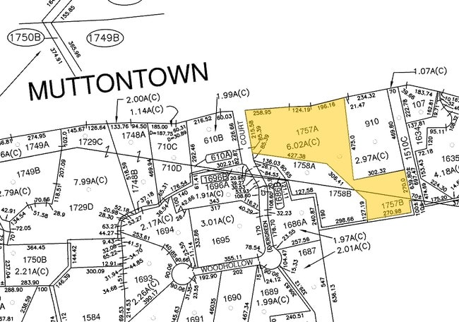
2429-16-B-00-1757-B
Nassau
Residentialacreage
New York
X
1757
36059C0133G
0.88 AC
2025
Eastern Nassau
2025
Long Island (New York)
517701
DEMOGRAPHICS near Muttontown Rd
1 Mile
3 Mile
5 Mile
2024 Total Population
1,097
44,486
170,995
2029 Population
1,085
44,096
168,225
Pop Growth 2024-2029
(1.09%)
(0.88%)
(1.62%)
Average Age
44
42
42
2024 Total Households
339
14,006
53,687
HH Growth 2024-2029
(1.47%)
(0.98%)
(1.73%)
Median Household Inc
$225,258
$168,508
$142,350
Avg Household Size
3.20
3.00
3.00
2024 Avg HH Vehicles
3.00
2.00
2.00
Median Home Value
$1,138,986
$855,454
$785,279
Median Year Built
1972
1961
1957
Nearby Places
- Restaurants
- Banks
- Shops
- Fitness
- Groceries
PUBLIC TRANSPORTATION
COMMUTER RAIL
Syosset Station (Port Jefferson Branch - Long Island Rail Road)
DRIVE
WALK
Distance
Syosset Station (Port Jefferson Branch - Long Island Rail Road)
6 min
2.6 mi
Oyster Bay Station (Oyster Bay Branch - Long Island Rail Road)
DRIVE
WALK
Distance
Oyster Bay Station (Oyster Bay Branch - Long Island Rail Road)
8 min
4.5 mi
AIRPORT
LaGuardia
DRIVE
WALK
Distance
LaGuardia
36 min
23.8 mi
John F Kennedy International
DRIVE
WALK
Distance
John F Kennedy International
38 min
24.1 mi
Westchester County
DRIVE
WALK
Distance
Westchester County
66 min
41.2 mi
Freight Ports
NY - Red Hook Container Terminal
DRIVE
WALK
Distance
NY - Red Hook Container Terminal
47 min
31.9 mi
Nearby Properties
Address
Land Use
TOTAL SIZE
Lot Size
Zoning
Address
Land Use
TOTAL SIZE
Lot Size
Zoning
114,205 SF
14.06 AC
497
Address
Land Use
TOTAL SIZE
Lot Size
Zoning
729,696 SF
579.18 AC
Address
Land Use
TOTAL SIZE
Lot Size
Zoning
600 SF
2.68 AC
Address
Land Use
TOTAL SIZE
Lot Size
Zoning
175,272 SF
209.20 AC
Address
Land Use
TOTAL SIZE
Lot Size
Zoning
95.70 AC
Address
Land Use
TOTAL SIZE
Lot Size
Zoning
469,586 SF
53.14 AC
Address
Land Use
TOTAL SIZE
Lot Size
Zoning
800 SF
45.25 AC
Address
Land Use
TOTAL SIZE
Lot Size
Zoning
105.79 AC
Address
Land Use
TOTAL SIZE
Lot Size
Zoning
160 SF
241.23 AC
Address
Land Use
TOTAL SIZE
Lot Size
Zoning
143,519 SF
20.67 AC
Address
Land Use
TOTAL SIZE
Lot Size
Zoning
534,840 SF
26.15 AC
Address
Land Use
TOTAL SIZE
Lot Size
Zoning
29,574 SF
174.23 AC
Address
Land Use
TOTAL SIZE
Lot Size
Zoning
146,287 SF
48.63 AC
Address
Land Use
TOTAL SIZE
Lot Size
Zoning
130,994 SF
27.94 AC
Address
Land Use
TOTAL SIZE
Lot Size
Zoning
98,802 SF
9.70 AC
Address
Land Use
TOTAL SIZE
Lot Size
Zoning
66,061 SF
18.79 AC
Address
Land Use
TOTAL SIZE
Lot Size
Zoning
28,537 SF
5.21 AC
Address
Land Use
TOTAL SIZE
Lot Size
Zoning
147,175 SF
10.28 AC
Address
Land Use
TOTAL SIZE
Lot Size
Zoning
204,726 SF
28.34 AC
Address
Land Use
TOTAL SIZE
Lot Size
Zoning
105,618 SF
23.48 AC
Address
Land Use
TOTAL SIZE
Lot Size
Zoning
546,788 SF
21.16 AC
Address
Land Use
TOTAL SIZE
Lot Size
Zoning
69,168 SF
15.12 AC
Address
Land Use
TOTAL SIZE
Lot Size
Zoning
102,846 SF
24.70 AC
Address
Land Use
TOTAL SIZE
Lot Size
Zoning
43.21 AC
Address
Land Use
TOTAL SIZE
Lot Size
Zoning
260,315 SF
16.60 AC
Address
Land Use
TOTAL SIZE
Lot Size
Zoning
52,156 SF
14.70 AC
Address
Land Use
TOTAL SIZE
Lot Size
Zoning
551,095 SF
22.42 AC
Address
Land Use
TOTAL SIZE
Lot Size
Zoning
183,394 SF
18.70 AC
Address
Land Use
TOTAL SIZE
Lot Size
Zoning
48,443 SF
30.98 AC
Address
Land Use
TOTAL SIZE
Lot Size
Zoning
3,960 SF
39.54 AC
The World's #1 Commercial Real Estate Marketplace
Connect with us
© 2025 CoStar Group
The information above has been obtained from sources believed reliable. While we do not doubt its accuracy we have not verified it and make no guarantee, warranty or representation about it. It is your responsibility to independently confirm its accuracy and completeness. Any projections, opinions, assumptions, or estimates used are for example only and do not represent the current or future performance of the property. The value of this transaction to you depends on tax and other factors which should be evaluated by your tax, financial, and legal advisors. You and your advisors should conduct a careful, independent investigation of the property to determine to your satisfaction the suitability of the property for your needs.