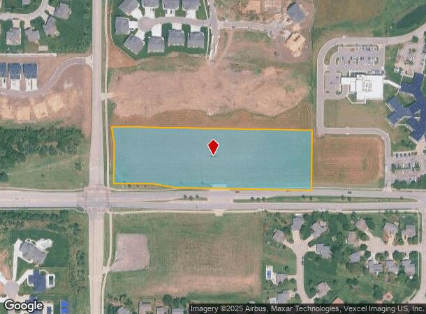
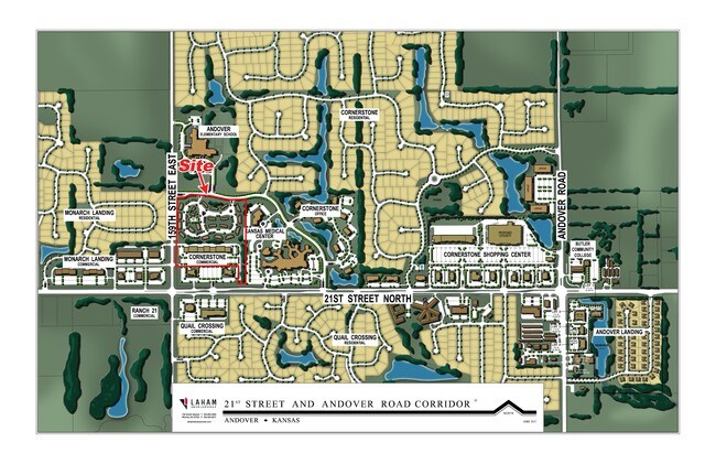
Property Record
N 159Th St E, Wichita, KS 67228

NEARBY LISTINGS FOR SALE OR LEASE
-
-
View all Wichita listings for sale on LoopNet.com
Property Detail
N 159Th St E
Wichita, KS
Cornerstone Commercial Add
303-06-0-30-04-003-00-0
CORNERSTONE COMMERCIAL ADD, S06, T27, R03E, BLOCK 1, LOT S265 LT 1, ACRES 5.3
Rangelandgrazing
Butler
X
Kansas
20173C0382G
1
2024
5.30 AC
2025
Outlying Butler County
010116
Wichita
DEMOGRAPHICS near N 159Th St E
1 Mile
3 Mile
5 Mile
2024 Total Population
4,571
24,978
49,331
2029 Population
4,741
25,514
50,434
Pop Growth 2024-2029
+ 3.72%
+ 2.15%
+ 2.24%
Average Age
34
38
39
2024 Total Households
1,455
8,536
17,764
HH Growth 2024-2029
+ 3.78%
+ 2.07%
+ 2.20%
Median Household Inc
$108,028
$119,009
$108,362
Avg Household Size
3.10
2.90
2.70
2024 Avg HH Vehicles
2.00
2.00
2.00
Median Home Value
$262,661
$308,688
$296,733
Median Year Built
2006
2002
1999
Nearby Places
Map Layers
Map Styles
 Street
 Aerial
- Restaurants
- Banks
- Shops
- Fitness
- Groceries
PUBLIC TRANSPORTATION
AIRPORT
Wichita Dwight D Eisenhower Ntl
DRIVE
WALK
Distance
Wichita Dwight D Eisenhower Ntl
30 min
20.7 mi
Freight Ports
Tulsa Port Of Catoosa
DRIVE
WALK
Distance
Tulsa Port Of Catoosa
215 min
201.3 mi
SALE & LEASE HISTORY
LISTING DATE
SALE/LEASE

Aug 23, 2017
For Sale
Nearby Properties
Address
Land Use
TOTAL SIZE
Lot Size
Zoning
Address
Land Use
TOTAL SIZE
Lot Size
Zoning
121.30 AC
Address
Land Use
TOTAL SIZE
Lot Size
Zoning
126.70 AC
Address
Land Use
TOTAL SIZE
Lot Size
Zoning
32.40 AC
Address
Land Use
TOTAL SIZE
Lot Size
Zoning
123,253 SF
14.60 AC
Address
Land Use
TOTAL SIZE
Lot Size
Zoning
138,233 SF
23.01 AC
SF-5
Address
Land Use
TOTAL SIZE
Lot Size
Zoning
136,627 SF
27.46 AC
SF-5
Address
Land Use
TOTAL SIZE
Lot Size
Zoning
88,652 SF
21.92 AC
SF-5
Address
Land Use
TOTAL SIZE
Lot Size
Zoning
71,058 SF
17.47 AC
SF-5
Address
Land Use
TOTAL SIZE
Lot Size
Zoning
19.70 AC
Address
Land Use
TOTAL SIZE
Lot Size
Zoning
15,597 SF
67.40 AC
Address
Land Use
TOTAL SIZE
Lot Size
Zoning
37,934 SF
24.82 AC
SF-5
Address
Land Use
TOTAL SIZE
Lot Size
Zoning
47,631 SF
13.66 AC
SF-5
Address
Land Use
TOTAL SIZE
Lot Size
Zoning
20.60 AC
Address
Land Use
TOTAL SIZE
Lot Size
Zoning
46,816 SF
14.69 AC
SF-5
Address
Land Use
TOTAL SIZE
Lot Size
Zoning
24.20 AC
Address
Land Use
TOTAL SIZE
Lot Size
Zoning
47,234 SF
8.70 AC
Address
Land Use
TOTAL SIZE
Lot Size
Zoning
14,582 SF
5.30 AC
Address
Land Use
TOTAL SIZE
Lot Size
Zoning
38,759 SF
14.86 AC
SF-5
Address
Land Use
TOTAL SIZE
Lot Size
Zoning
19,396 SF
54.52 AC
LC,SF-5
Address
Land Use
TOTAL SIZE
Lot Size
Zoning
20,113 SF
2.90 AC
Address
Land Use
TOTAL SIZE
Lot Size
Zoning
32,561 SF
18.04 AC
SF-5
Address
Land Use
TOTAL SIZE
Lot Size
Zoning
70,937 SF
9.60 AC
Address
Land Use
TOTAL SIZE
Lot Size
Zoning
237,546 SF
34.16 AC
MF-18
Address
Land Use
TOTAL SIZE
Lot Size
Zoning
83,625 SF
11 AC
Address
Land Use
TOTAL SIZE
Lot Size
Zoning
49,392 SF
11.21 AC
SF-5
Address
Land Use
TOTAL SIZE
Lot Size
Zoning
125,112 SF
5.32 AC
GO
Address
Land Use
TOTAL SIZE
Lot Size
Zoning
76,022 SF
15.15 AC
LC
Address
Land Use
TOTAL SIZE
Lot Size
Zoning
129,575 SF
10.29 AC
LC
Address
Land Use
TOTAL SIZE
Lot Size
Zoning
20,744 SF
2.50 AC
Address
Land Use
TOTAL SIZE
Lot Size
Zoning
80,984 SF
7.92 AC
LI
The World's #1 Commercial Real Estate Marketplace
Connect with us
© 2025 CoStar Group
The information above has been obtained from sources believed reliable. While we do not doubt its accuracy we have not verified it and make no guarantee, warranty or representation about it. It is your responsibility to independently confirm its accuracy and completeness. Any projections, opinions, assumptions, or estimates used are for example only and do not represent the current or future performance of the property. The value of this transaction to you depends on tax and other factors which should be evaluated by your tax, financial, and legal advisors. You and your advisors should conduct a careful, independent investigation of the property to determine to your satisfaction the suitability of the property for your needs.