Property Record
N 25Th St, Middlesboro, KY 40965
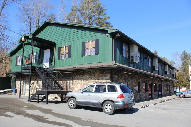


Property Detail
N 25Th St
Commercialnec
NE BT2 (LOT & STORE BLDG & CAR WASH)
RESIDENTIA
BELL
B and X Area of moderate flood hazard, usually the area between the limits of the 100-year and 500-year floods.
Kentucky
2025
Corbin/London Area
2025
Other Market Areas
960700
Middlesborough, KY
10,400 SF
069-30-00-247.00
NEARBY LISTINGS FOR SALE OR LEASE
-
-
View all Middlesboro listings for sale on LoopNet.com
DEMOGRAPHICS near N 25Th St
1 mile
3 mile
5 mile
2025 Total Population
2,761
10,940
13,031
2030 Population
2,665
10,604
12,694
Pop Growth 2025-2030
(3.48%)
(3.07%)
(2.59%)
Average Age
41
41
41
2025 Total Households
1,161
4,572
5,407
HH Growth 2025-2030
(3.62%)
(3.13%)
(2.63%)
Median Household Inc
$40,475
$31,352
$32,873
Avg Household Size
2.30
2.30
2.30
2025 Avg HH Vehicles
2.00
2.00
2.00
Median Home Value
$124,215
$91,547
$98,877
Median Year Built
1972
1970
1972
Nearby Places
Map Layers
Map Styles
 Street
 Aerial
Layers
 Traffic
 Biking
Places
Listings with unknown addresses are not visible on the map
- Restaurants
- Banks
- Shops
- Fitness
- Groceries
SALE & LEASE HISTORY
LISTING DATE
SALE/LEASE

Jan 31, 2022
For Sale
Nearby Properties
Address
Land Use
TOTAL SIZE
Lot Size
Zoning
Address
Land Use
TOTAL SIZE
Lot Size
Zoning
Address
Land Use
TOTAL SIZE
Lot Size
Zoning
Address
Land Use
TOTAL SIZE
Lot Size
Zoning
Address
Land Use
TOTAL SIZE
Lot Size
Zoning
9,960 SF
Address
Land Use
TOTAL SIZE
Lot Size
Zoning
Address
Land Use
TOTAL SIZE
Lot Size
Zoning
Address
Land Use
TOTAL SIZE
Lot Size
Zoning
48,116 SF
Address
Land Use
TOTAL SIZE
Lot Size
Zoning
19,120 SF
RESIDENTIA
Address
Land Use
TOTAL SIZE
Lot Size
Zoning
Address
Land Use
TOTAL SIZE
Lot Size
Zoning
Address
Land Use
TOTAL SIZE
Lot Size
Zoning
Address
Land Use
TOTAL SIZE
Lot Size
Zoning
Address
Land Use
TOTAL SIZE
Lot Size
Zoning
278.73 AC
Address
Land Use
TOTAL SIZE
Lot Size
Zoning
29,469 SF
13 AC
Address
Land Use
TOTAL SIZE
Lot Size
Zoning
Address
Land Use
TOTAL SIZE
Lot Size
Zoning
Address
Land Use
TOTAL SIZE
Lot Size
Zoning
10,348 SF
Address
Land Use
TOTAL SIZE
Lot Size
Zoning
Address
Land Use
TOTAL SIZE
Lot Size
Zoning
Address
Land Use
TOTAL SIZE
Lot Size
Zoning
5,517 SF
Address
Land Use
TOTAL SIZE
Lot Size
Zoning
2,880 SF
0.91 AC
Address
Land Use
TOTAL SIZE
Lot Size
Zoning
5,428 SF
Address
Land Use
TOTAL SIZE
Lot Size
Zoning
33,678 SF
Address
Land Use
TOTAL SIZE
Lot Size
Zoning
Address
Land Use
TOTAL SIZE
Lot Size
Zoning
Address
Land Use
TOTAL SIZE
Lot Size
Zoning
23,392 SF
RESIDENTIA
The World's #1 Commercial Real Estate Marketplace
Connect with us
© 2026 CoStar Group
The information above has been obtained from sources believed reliable. While we do not doubt its accuracy we have not verified it and make no guarantee, warranty or representation about it. It is your responsibility to independently confirm its accuracy and completeness. Any projections, opinions, assumptions, or estimates used are for example only and do not represent the current or future performance of the property. The value of this transaction to you depends on tax and other factors which should be evaluated by your tax, financial, and legal advisors. You and your advisors should conduct a careful, independent investigation of the property to determine to your satisfaction the suitability of the property for your needs.