Property Record
N 57Th St, Yakima, WA 98901
NEARBY LISTINGS FOR SALE OR LEASE
Property Detail
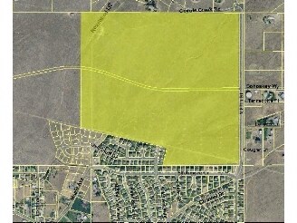
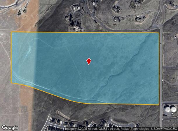
N 57Th St
191315-11004
SECTION 15 TOWNSHIP 13 RANGE 19 QUARTER NE: PTN FOL DESC PARCEL LY NLY OF CO RD R/W ( AS GRANTED TO YAKIMA COUNTY 11/16/2001 BY COURT ORDER 01-2-02720-3): BEG N1/4 COR, TH N 89^3435W 170.01 FT, TH S 0^0347E 2014.04 FT, TH S 77^0528E 1522.16 FT, TH S
Recreationalacreage
Yakima
X
Washington
53077C1060D
76.63 AC
2025
Outlying Yakima County
2025
Yakima
001602
Yakima, WA
DEMOGRAPHICS near N 57Th St
1 Mile
3 Mile
5 Mile
2024 Total Population
3,351
12,107
57,793
2029 Population
3,377
12,231
57,935
Pop Growth 2024-2029
+ 0.78%
+ 1.02%
+ 0.25%
Average Age
41
39
35
2024 Total Households
1,269
4,574
19,717
HH Growth 2024-2029
+ 0.71%
+ 1.01%
+ 0.19%
Median Household Inc
$92,654
$70,017
$46,402
Avg Household Size
2.60
2.50
2.80
2024 Avg HH Vehicles
2.00
2.00
2.00
Median Home Value
$336,745
$317,573
$211,210
Median Year Built
1991
1990
1972
Nearby Places
Map Layers
Map Styles
 Street
 Aerial
- Restaurants
- Banks
- Shops
- Fitness
- Groceries
PUBLIC TRANSPORTATION
AIRPORT
Yakima Air Trml/McAllister Field
DRIVE
WALK
Distance
Yakima Air Trml/McAllister Field
23 min
8.9 mi
Freight Ports
Port of Tacoma
DRIVE
WALK
Distance
Port of Tacoma
191 min
159.0 mi
Nearby Properties
Address
Land Use
TOTAL SIZE
Lot Size
Zoning
Address
Land Use
TOTAL SIZE
Lot Size
Zoning
197,341 SF
36.70 AC
GC
Address
Land Use
TOTAL SIZE
Lot Size
Zoning
129,042 SF
6.53 AC
R3
Address
Land Use
TOTAL SIZE
Lot Size
Zoning
121,488 SF
5.97 AC
R3
Address
Land Use
TOTAL SIZE
Lot Size
Zoning
97,056 SF
5.80 AC
R3
Address
Land Use
TOTAL SIZE
Lot Size
Zoning
197,263 SF
18.08 AC
C1
Address
Land Use
TOTAL SIZE
Lot Size
Zoning
84,714 SF
4.40 AC
R3
Address
Land Use
TOTAL SIZE
Lot Size
Zoning
83,856 SF
4.23 AC
R3
Address
Land Use
TOTAL SIZE
Lot Size
Zoning
64,593 SF
10.02 AC
R1
Address
Land Use
TOTAL SIZE
Lot Size
Zoning
76,160 SF
39.51 AC
M1
Address
Land Use
TOTAL SIZE
Lot Size
Zoning
427,713 SF
22.43 AC
M1
Address
Land Use
TOTAL SIZE
Lot Size
Zoning
50,919 SF
1.99 AC
C1
Address
Land Use
TOTAL SIZE
Lot Size
Zoning
141,696 SF
6.42 AC
M1
Address
Land Use
TOTAL SIZE
Lot Size
Zoning
70,164 SF
16.03 AC
M1
Address
Land Use
TOTAL SIZE
Lot Size
Zoning
56,973 SF
6.06 AC
R3
Address
Land Use
TOTAL SIZE
Lot Size
Zoning
115,885 SF
7.83 AC
RD
Address
Land Use
TOTAL SIZE
Lot Size
Zoning
30,327 SF
3.52 AC
GC
Address
Land Use
TOTAL SIZE
Lot Size
Zoning
34,422 SF
2.96 AC
M1
Address
Land Use
TOTAL SIZE
Lot Size
Zoning
66,756 SF
5.19 AC
M1
Address
Land Use
TOTAL SIZE
Lot Size
Zoning
77,646 SF
3.18 AC
RD
Address
Land Use
TOTAL SIZE
Lot Size
Zoning
70,000 SF
8.46 AC
C1
Address
Land Use
TOTAL SIZE
Lot Size
Zoning
115,658 SF
20.69 AC
AG
Address
Land Use
TOTAL SIZE
Lot Size
Zoning
44,800 SF
4.08 AC
GC
Address
Land Use
TOTAL SIZE
Lot Size
Zoning
32,255 SF
16 AC
RD
Address
Land Use
TOTAL SIZE
Lot Size
Zoning
69,008 SF
2.97 AC
C1
Address
Land Use
TOTAL SIZE
Lot Size
Zoning
9,038 SF
27.46 AC
SR
Address
Land Use
TOTAL SIZE
Lot Size
Zoning
17,136 SF
52.87 AC
SR
Address
Land Use
TOTAL SIZE
Lot Size
Zoning
44,524 SF
1.97 AC
C1
Address
Land Use
TOTAL SIZE
Lot Size
Zoning
11.03 AC
RD
Address
Land Use
TOTAL SIZE
Lot Size
Zoning
45,300 SF
3.07 AC
M1
The World's #1 Commercial Real Estate Marketplace
Connect with us
© 2026 CoStar Group
The information above has been obtained from sources believed reliable. While we do not doubt its accuracy we have not verified it and make no guarantee, warranty or representation about it. It is your responsibility to independently confirm its accuracy and completeness. Any projections, opinions, assumptions, or estimates used are for example only and do not represent the current or future performance of the property. The value of this transaction to you depends on tax and other factors which should be evaluated by your tax, financial, and legal advisors. You and your advisors should conduct a careful, independent investigation of the property to determine to your satisfaction the suitability of the property for your needs.