Property Record
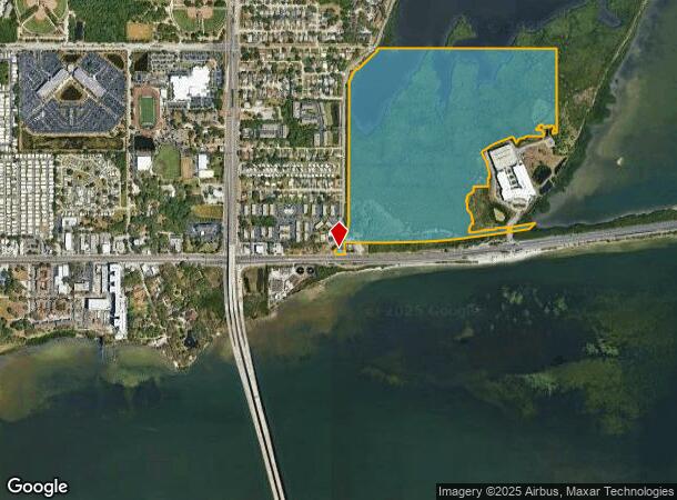
N Bayshore Blvd, Clearwater, FL 33759
NEARBY LISTINGS FOR SALE OR LEASE
Property Detail
N Bayshore Blvd
Tampa-St. Petersburg-Clearwater, FL
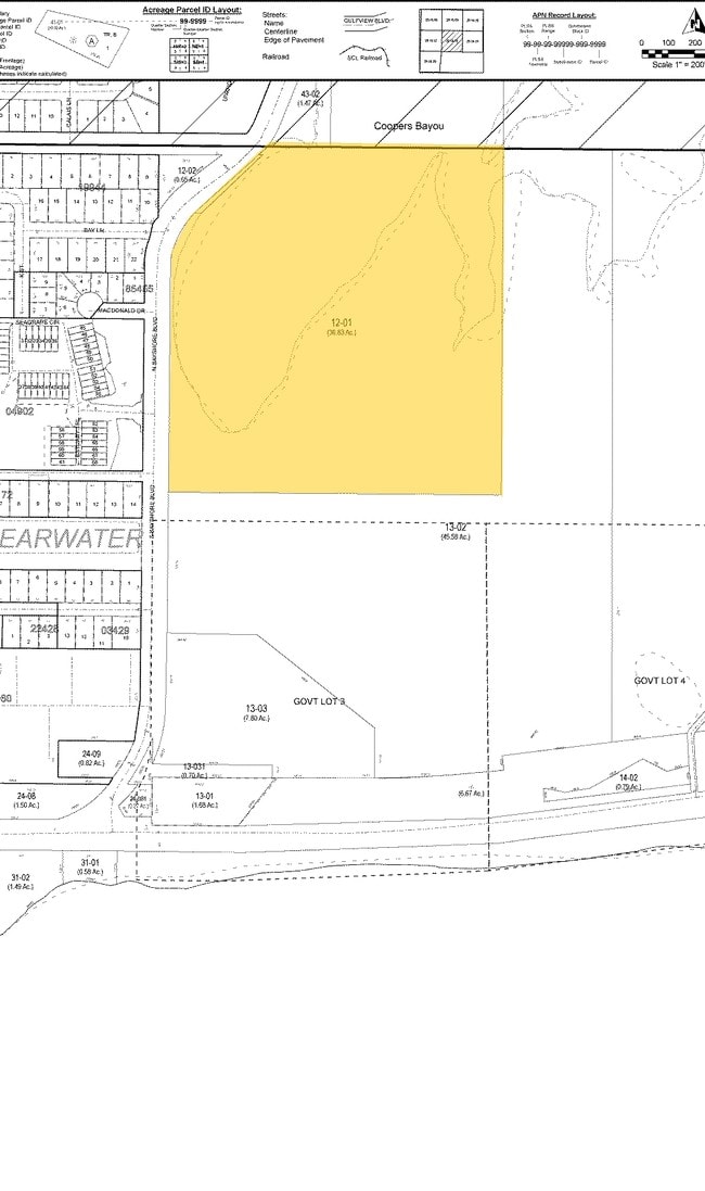
That Part Of Ne 1/4 Of Sec
16-29-16-00000-120-0100
THAT PART OF NE 1/4 OF SEC 16-29-16 & THAT PART OF SE 1/4 OF SE 1/4 OF NW 1/4 OF SEC 16-29-16 ALL N OF SR 60 & E OF S BAYSHORE BLVD LESS THOSE PARTS DESC IN O.R. 8094/1155 AND O.R. 13792/1036 AND O.R. 19452/1497 AND LESS THOSE PARTS DEEDED TO FL DOT
Commercialacreage
Pinellas
AE
Florida
12103C0129H
113.37 AC
0
Bayside
2025
Tampa/St Petersburg
026804
DEMOGRAPHICS near N Bayshore Blvd
1 Mile
3 Mile
5 Mile
2024 Total Population
4,365
58,241
172,306
2029 Population
4,427
59,038
173,066
Pop Growth 2024-2029
+ 1.42%
+ 1.37%
+ 0.44%
Average Age
48
45
46
2024 Total Households
2,132
27,263
78,093
HH Growth 2024-2029
+ 0.94%
+ 1.34%
+ 0.34%
Median Household Inc
$62,121
$59,457
$57,747
Avg Household Size
1.90
2.10
2.10
2024 Avg HH Vehicles
1.00
2.00
2.00
Median Home Value
$315,384
$255,333
$252,809
Median Year Built
1976
1979
1978
Nearby Places
Map Layers
Map Styles
 Street
 Aerial
- Restaurants
- Banks
- Shops
- Fitness
- Groceries
PUBLIC TRANSPORTATION
AIRPORT
St Pete-Clearwater International
DRIVE
WALK
Distance
St Pete-Clearwater International
18 min
8.5 mi
Tampa International
DRIVE
WALK
Distance
Tampa International
19 min
12.2 mi
Freight Ports
Port of Tampa Bay
DRIVE
WALK
Distance
Port of Tampa Bay
33 min
20.7 mi
Nearby Properties
Address
Land Use
TOTAL SIZE
Lot Size
Zoning
Address
Land Use
TOTAL SIZE
Lot Size
Zoning
524,588 SF
17.15 AC
Address
Land Use
TOTAL SIZE
Lot Size
Zoning
470,181 SF
29.93 AC
Address
Land Use
TOTAL SIZE
Lot Size
Zoning
563,328 SF
27.34 AC
Address
Land Use
TOTAL SIZE
Lot Size
Zoning
435,202 SF
9.80 AC
R3
Address
Land Use
TOTAL SIZE
Lot Size
Zoning
389,810 SF
16.93 AC
Address
Land Use
TOTAL SIZE
Lot Size
Zoning
498,319 SF
15.52 AC
Address
Land Use
TOTAL SIZE
Lot Size
Zoning
452,179 SF
5.75 AC
R4
Address
Land Use
TOTAL SIZE
Lot Size
Zoning
288,467 SF
43.51 AC
Address
Land Use
TOTAL SIZE
Lot Size
Zoning
305,970 SF
39.74 AC
Address
Land Use
TOTAL SIZE
Lot Size
Zoning
492,016 SF
19.86 AC
Address
Land Use
TOTAL SIZE
Lot Size
Zoning
313,486 SF
18.42 AC
Address
Land Use
TOTAL SIZE
Lot Size
Zoning
337,954 SF
21 AC
R3
Address
Land Use
TOTAL SIZE
Lot Size
Zoning
325,591 SF
31.97 AC
Address
Land Use
TOTAL SIZE
Lot Size
Zoning
352,647 SF
14.88 AC
Address
Land Use
TOTAL SIZE
Lot Size
Zoning
171,150 SF
17.58 AC
Address
Land Use
TOTAL SIZE
Lot Size
Zoning
284,609 SF
15.57 AC
Address
Land Use
TOTAL SIZE
Lot Size
Zoning
662,010 SF
33.76 AC
Address
Land Use
TOTAL SIZE
Lot Size
Zoning
396,822 SF
36.20 AC
RPD5
Address
Land Use
TOTAL SIZE
Lot Size
Zoning
492,747 SF
19.89 AC
Address
Land Use
TOTAL SIZE
Lot Size
Zoning
321,395 SF
25.22 AC
Address
Land Use
TOTAL SIZE
Lot Size
Zoning
160,014 SF
7.77 AC
Address
Land Use
TOTAL SIZE
Lot Size
Zoning
223,944 SF
12.13 AC
Address
Land Use
TOTAL SIZE
Lot Size
Zoning
239,340 SF
17.27 AC
Address
Land Use
TOTAL SIZE
Lot Size
Zoning
244,655 SF
16.84 AC
AE
Address
Land Use
TOTAL SIZE
Lot Size
Zoning
258,472 SF
18.23 AC
Address
Land Use
TOTAL SIZE
Lot Size
Zoning
251,016 SF
10.10 AC
AE
Address
Land Use
TOTAL SIZE
Lot Size
Zoning
284,000 SF
36.09 AC
Address
Land Use
TOTAL SIZE
Lot Size
Zoning
226,562 SF
11.08 AC
Address
Land Use
TOTAL SIZE
Lot Size
Zoning
208,637 SF
16.83 AC
M1
Address
Land Use
TOTAL SIZE
Lot Size
Zoning
160,827 SF
20.22 AC
AE
The World's #1 Commercial Real Estate Marketplace
Connect with us
© 2025 CoStar Group
The information above has been obtained from sources believed reliable. While we do not doubt its accuracy we have not verified it and make no guarantee, warranty or representation about it. It is your responsibility to independently confirm its accuracy and completeness. Any projections, opinions, assumptions, or estimates used are for example only and do not represent the current or future performance of the property. The value of this transaction to you depends on tax and other factors which should be evaluated by your tax, financial, and legal advisors. You and your advisors should conduct a careful, independent investigation of the property to determine to your satisfaction the suitability of the property for your needs.