Property Record
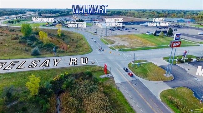
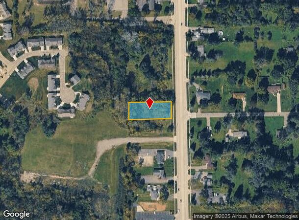
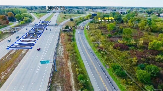
N Belsay Rd, Burton, MI 48509
NEARBY LISTINGS FOR SALE OR LEASE
Property Detail
N Belsay Rd
Flint, MI
Daly Ranch Homesites
59-11-526-010
LOT 10 DALY RANCH-HOMESITES
Commercialacreage
Genesee
X
Michigan
26049C0213D
10
2024
0.57 AC
2025
Flint
011502
Detroit
DEMOGRAPHICS near N Belsay Rd
1 mile
3 mile
5 mile
2024 Total Population
1,904
31,180
92,801
2029 Population
1,861
30,374
91,718
Pop Growth 2024-2029
(2.26%)
(2.58%)
(1.17%)
Average Age
43
42
40
2024 Total Households
761
13,222
38,949
HH Growth 2024-2029
(2.23%)
(2.58%)
(1.26%)
Median Household Inc
$66,098
$56,617
$48,958
Avg Household Size
2.40
2.30
2.30
2024 Avg HH Vehicles
2.00
2.00
2.00
Median Home Value
$177,090
$140,736
$133,527
Median Year Built
1962
1963
1966
Nearby Places
Map Layers
Map Styles
 Street
 Aerial
Transit
 Traffic
 Biking
Places
Listings with unknown addresses are not visible on the map
- Restaurants
- Banks
- Shops
- Fitness
- Groceries
PUBLIC TRANSPORTATION
COMMUTER RAIL
Flint Amtrak Station (Blue Water - Amtrak)
Drive
Walk
Distance
Flint Amtrak Station (Blue Water - Amtrak)
7 min
4.0 mi
AIRPORT
Bishop International
Drive
Walk
Distance
Bishop International
25 min
13.4 mi
Freight Ports
Port of Toledo
Drive
Walk
Distance
Port of Toledo
140 min
119.2 mi
SALE & LEASE HISTORY
LISTING DATE
SALE/LEASE

Sep 24, 2016
For Sale
Sep 06, 2022
For Sale
Nov 08, 2017
For Sale
Mar 27, 2020
For Sale
Nearby Properties
Address
Land Use
TOTAL SIZE
Lot Size
Zoning
Address
Land Use
TOTAL SIZE
Lot Size
Zoning
MOBILE
Address
Land Use
TOTAL SIZE
Lot Size
Zoning
217,010 SF
18.08 AC
Address
Land Use
TOTAL SIZE
Lot Size
Zoning
51.59 AC
NOT AVAILA
Address
Land Use
TOTAL SIZE
Lot Size
Zoning
290,267 SF
79 AC
PC
Address
Land Use
TOTAL SIZE
Lot Size
Zoning
302,862 SF
27.14 AC
NOT AVAILA
Address
Land Use
TOTAL SIZE
Lot Size
Zoning
227,669 SF
25.87 AC
C-2
Address
Land Use
TOTAL SIZE
Lot Size
Zoning
157,741 SF
33.61 AC
Address
Land Use
TOTAL SIZE
Lot Size
Zoning
354,079 SF
48.41 AC
C-4
Address
Land Use
TOTAL SIZE
Lot Size
Zoning
371,636 SF
12.50 AC
M-1
Address
Land Use
TOTAL SIZE
Lot Size
Zoning
Address
Land Use
TOTAL SIZE
Lot Size
Zoning
60,613 SF
12.91 AC
RO
Address
Land Use
TOTAL SIZE
Lot Size
Zoning
111,882 SF
5.36 AC
C-4
Address
Land Use
TOTAL SIZE
Lot Size
Zoning
419,038 SF
57.18 AC
M-2
Address
Land Use
TOTAL SIZE
Lot Size
Zoning
136,506 SF
16.54 AC
C-4
Address
Land Use
TOTAL SIZE
Lot Size
Zoning
Address
Land Use
TOTAL SIZE
Lot Size
Zoning
218,229 SF
37.64 AC
CE
Address
Land Use
TOTAL SIZE
Lot Size
Zoning
107,580 SF
5.18 AC
RETAIL
Address
Land Use
TOTAL SIZE
Lot Size
Zoning
82,240 SF
15.03 AC
C-2
Address
Land Use
TOTAL SIZE
Lot Size
Zoning
60,692 SF
64.65 AC
NOT AVAILA
Address
Land Use
TOTAL SIZE
Lot Size
Zoning
192,900 SF
6.50 AC
CE
Address
Land Use
TOTAL SIZE
Lot Size
Zoning
118,210 SF
6.60 AC
CE
Address
Land Use
TOTAL SIZE
Lot Size
Zoning
14,336 SF
3.29 AC
NOT AVAILA
Address
Land Use
TOTAL SIZE
Lot Size
Zoning
72,720 SF
6.41 AC
C-2
Address
Land Use
TOTAL SIZE
Lot Size
Zoning
25.50 AC
NOT AVAILA
Address
Land Use
TOTAL SIZE
Lot Size
Zoning
726 SF
10.40 AC
R-4 MANUF
Address
Land Use
TOTAL SIZE
Lot Size
Zoning
49,688 SF
8.79 AC
NOT AVAILA
Address
Land Use
TOTAL SIZE
Lot Size
Zoning
19,744 SF
3.52 AC
C-2
Address
Land Use
TOTAL SIZE
Lot Size
Zoning
10,806 SF
6.52 AC
NOT AVAILA
Address
Land Use
TOTAL SIZE
Lot Size
Zoning
10.05 AC
NOT AVAILA
Address
Land Use
TOTAL SIZE
Lot Size
Zoning
58,197 SF
11.90 AC
C-2
The World's #1 Commercial Real Estate Marketplace
Connect with us
© 2026 CoStar Group
The information above has been obtained from sources believed reliable. While we do not doubt its accuracy we have not verified it and make no guarantee, warranty or representation about it. It is your responsibility to independently confirm its accuracy and completeness. Any projections, opinions, assumptions, or estimates used are for example only and do not represent the current or future performance of the property. The value of this transaction to you depends on tax and other factors which should be evaluated by your tax, financial, and legal advisors. You and your advisors should conduct a careful, independent investigation of the property to determine to your satisfaction the suitability of the property for your needs.