Property Record
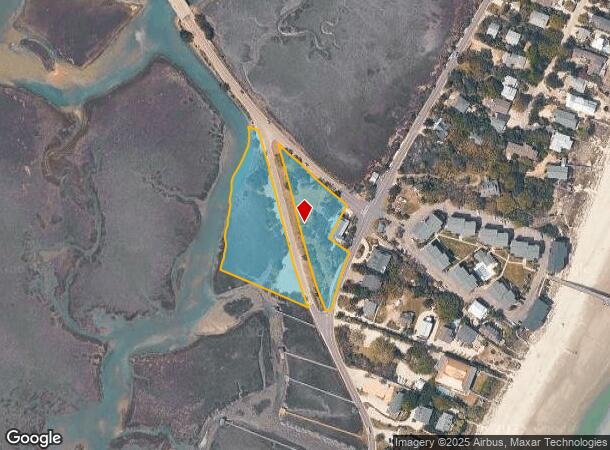
N Causeway Rd, Pawleys Island, SC 29585
NEARBY LISTINGS FOR SALE OR LEASE
-
-
View all Pawleys Island listings for sale on LoopNet.com
Property Detail
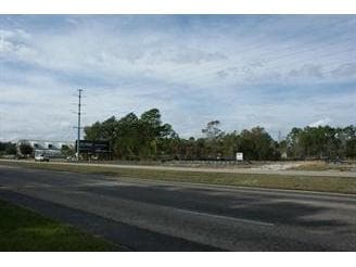
N Causeway Rd
Murrells Inlet, SC
Pi
42-0167-002-00-00
SAME AS 37-381; PLT 3224-285
Municipalproperty
Georgetown
AE
South Carolina
45043C0390G
2.94 AC
0
Myrtle Beach South
2024
Other Market Areas
920507
DEMOGRAPHICS near N Causeway Rd
1 Mile
3 Mile
5 Mile
2024 Total Population
1,512
12,463
20,222
2029 Population
1,648
13,302
21,745
Pop Growth 2024-2029
+ 8.99%
+ 6.73%
+ 7.53%
Average Age
53
52
53
2024 Total Households
723
5,683
9,291
HH Growth 2024-2029
+ 8.71%
+ 6.48%
+ 7.31%
Median Household Inc
$64,303
$66,728
$80,166
Avg Household Size
2.10
2.20
2.10
2024 Avg HH Vehicles
2.00
2.00
2.00
Median Home Value
$319,231
$334,647
$382,716
Median Year Built
1993
1995
1996
Nearby Places
Map Layers
Map Styles
 Street
 Aerial
- Restaurants
- Banks
- Shops
- Fitness
- Groceries
PUBLIC TRANSPORTATION
AIRPORT
Myrtle Beach International
DRIVE
WALK
Distance
Myrtle Beach International
39 min
25.3 mi
Freight Ports
Wando Welch Terminal
DRIVE
WALK
Distance
Wando Welch Terminal
90 min
66.8 mi
Nearby Properties
Address
Land Use
TOTAL SIZE
Lot Size
Zoning
Address
Land Use
TOTAL SIZE
Lot Size
Zoning
Address
Land Use
TOTAL SIZE
Lot Size
Zoning
35.20 AC
Address
Land Use
TOTAL SIZE
Lot Size
Zoning
19,489 SF
11.49 AC
Address
Land Use
TOTAL SIZE
Lot Size
Zoning
Address
Land Use
TOTAL SIZE
Lot Size
Zoning
Address
Land Use
TOTAL SIZE
Lot Size
Zoning
5,897 SF
15.25 AC
Address
Land Use
TOTAL SIZE
Lot Size
Zoning
5,831 SF
116.51 AC
Address
Land Use
TOTAL SIZE
Lot Size
Zoning
24,080 SF
3.50 AC
Address
Land Use
TOTAL SIZE
Lot Size
Zoning
Address
Land Use
TOTAL SIZE
Lot Size
Zoning
2.48 AC
Address
Land Use
TOTAL SIZE
Lot Size
Zoning
11,250 SF
4.39 AC
Address
Land Use
TOTAL SIZE
Lot Size
Zoning
8,000 SF
2.79 AC
Address
Land Use
TOTAL SIZE
Lot Size
Zoning
Address
Land Use
TOTAL SIZE
Lot Size
Zoning
2,606 SF
0.21 AC
Address
Land Use
TOTAL SIZE
Lot Size
Zoning
123,437 SF
12.01 AC
Address
Land Use
TOTAL SIZE
Lot Size
Zoning
4,802 SF
0.35 AC
Address
Land Use
TOTAL SIZE
Lot Size
Zoning
14.45 AC
Address
Land Use
TOTAL SIZE
Lot Size
Zoning
6,735 SF
1.38 AC
Address
Land Use
TOTAL SIZE
Lot Size
Zoning
0.16 AC
Address
Land Use
TOTAL SIZE
Lot Size
Zoning
0.42 AC
Address
Land Use
TOTAL SIZE
Lot Size
Zoning
3,699 SF
1 AC
Address
Land Use
TOTAL SIZE
Lot Size
Zoning
2,861 SF
0.56 AC
Address
Land Use
TOTAL SIZE
Lot Size
Zoning
6,240 SF
0.48 AC
Address
Land Use
TOTAL SIZE
Lot Size
Zoning
2,748 SF
0.61 AC
Address
Land Use
TOTAL SIZE
Lot Size
Zoning
2,436 SF
0.13 AC
Address
Land Use
TOTAL SIZE
Lot Size
Zoning
6,427 SF
5.19 AC
Address
Land Use
TOTAL SIZE
Lot Size
Zoning
1,919 SF
1 AC
Address
Land Use
TOTAL SIZE
Lot Size
Zoning
7,150 SF
0.95 AC
Address
Land Use
TOTAL SIZE
Lot Size
Zoning
4,280 SF
0.69 AC
The World's #1 Commercial Real Estate Marketplace
Connect with us
© 2026 CoStar Group
The information above has been obtained from sources believed reliable. While we do not doubt its accuracy we have not verified it and make no guarantee, warranty or representation about it. It is your responsibility to independently confirm its accuracy and completeness. Any projections, opinions, assumptions, or estimates used are for example only and do not represent the current or future performance of the property. The value of this transaction to you depends on tax and other factors which should be evaluated by your tax, financial, and legal advisors. You and your advisors should conduct a careful, independent investigation of the property to determine to your satisfaction the suitability of the property for your needs.