Property Record
N Dixie Dr, Vandalia, OH 45377

Property Detail
N Dixie Dr
A01-00203-0085
6E-3-4
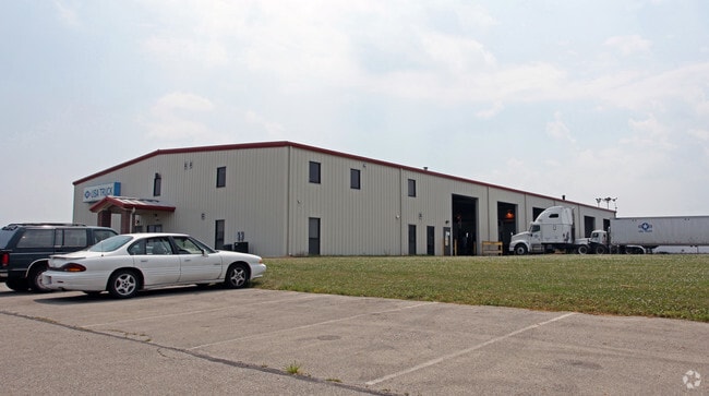
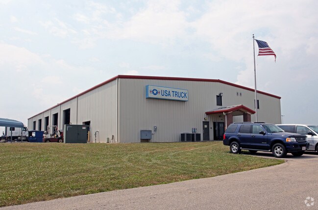
Truckterminal
MONTGOMERY
B and X Area of moderate flood hazard, usually the area between the limits of the 100-year and 500-year floods.
Ohio
2024
44.51 AC
2025
North Dayton
115011
Cincinnati/Dayton
29,150 SF
Dayton, OH
NEARBY LISTINGS FOR SALE OR LEASE
-
-
View all Vandalia listings for sale on LoopNet.com
DEMOGRAPHICS near N Dixie Dr
1 mile
3 mile
5 mile
2025 Total Population
380
17,885
43,523
2030 Population
384
17,850
43,756
Pop Growth 2025-2030
+ 1.05%
(0.20%)
+ 0.54%
Average Age
44
43
43
2025 Total Households
153
7,741
17,998
HH Growth 2025-2030
+ 0.65%
(0.31%)
+ 0.42%
Median Household Inc
$110,937
$76,731
$84,773
Avg Household Size
2.40
2.20
2.40
2025 Avg HH Vehicles
3.00
2.00
2.00
Median Home Value
$341,463
$234,132
$258,781
Median Year Built
1975
1970
1974
Nearby Places
Map Layers
Map Styles
 Street
 Aerial
Layers
 Traffic
 Biking
Places
Listings with unknown addresses are not visible on the map
- Restaurants
- Banks
- Shops
- Fitness
- Groceries
PUBLIC TRANSPORTATION
AIRPORT
James M Cox Dayton International
Drive
Walk
Distance
James M Cox Dayton International
11 min
5.2 mi
Freight Ports
Port of Toledo
Drive
Walk
Distance
Port of Toledo
167 min
141.6 mi
Nearby Properties
Address
Land Use
TOTAL SIZE
Lot Size
Zoning
Address
Land Use
TOTAL SIZE
Lot Size
Zoning
Address
Land Use
TOTAL SIZE
Lot Size
Zoning
Address
Land Use
TOTAL SIZE
Lot Size
Zoning
27,623 SF
6.54 AC
Address
Land Use
TOTAL SIZE
Lot Size
Zoning
678,154 SF
858.39 AC
Address
Land Use
TOTAL SIZE
Lot Size
Zoning
54,635 SF
17.25 AC
Address
Land Use
TOTAL SIZE
Lot Size
Zoning
704,988 SF
49.15 AC
Address
Land Use
TOTAL SIZE
Lot Size
Zoning
664,824 SF
1,128.84 AC
Address
Land Use
TOTAL SIZE
Lot Size
Zoning
Address
Land Use
TOTAL SIZE
Lot Size
Zoning
37.86 AC
Address
Land Use
TOTAL SIZE
Lot Size
Zoning
527,904 SF
75.77 AC
Address
Land Use
TOTAL SIZE
Lot Size
Zoning
730,000 SF
56.40 AC
Address
Land Use
TOTAL SIZE
Lot Size
Zoning
522,340 SF
36.59 AC
Address
Land Use
TOTAL SIZE
Lot Size
Zoning
45,980 SF
6.05 AC
Address
Land Use
TOTAL SIZE
Lot Size
Zoning
433,792 SF
34.46 AC
Address
Land Use
TOTAL SIZE
Lot Size
Zoning
425,641 SF
33.79 AC
Address
Land Use
TOTAL SIZE
Lot Size
Zoning
172,753 SF
23.76 AC
Address
Land Use
TOTAL SIZE
Lot Size
Zoning
28,208 SF
10.32 AC
Address
Land Use
TOTAL SIZE
Lot Size
Zoning
21,473 SF
8.37 AC
Address
Land Use
TOTAL SIZE
Lot Size
Zoning
143,980 SF
35.40 AC
Address
Land Use
TOTAL SIZE
Lot Size
Zoning
2,430 SF
371.47 AC
Address
Land Use
TOTAL SIZE
Lot Size
Zoning
14,850 SF
1.78 AC
Address
Land Use
TOTAL SIZE
Lot Size
Zoning
179,704 SF
18.68 AC
Address
Land Use
TOTAL SIZE
Lot Size
Zoning
92,985 SF
14.50 AC
Address
Land Use
TOTAL SIZE
Lot Size
Zoning
126,038 SF
13.78 AC
Address
Land Use
TOTAL SIZE
Lot Size
Zoning
184,413 SF
9.39 AC
Address
Land Use
TOTAL SIZE
Lot Size
Zoning
122,400 SF
20.34 AC
Address
Land Use
TOTAL SIZE
Lot Size
Zoning
164,834 SF
24.53 AC
Address
Land Use
TOTAL SIZE
Lot Size
Zoning
41,084 SF
13.28 AC
Address
Land Use
TOTAL SIZE
Lot Size
Zoning
1,778 SF
10.62 AC
Address
Land Use
TOTAL SIZE
Lot Size
Zoning
198,560 SF
16.25 AC
The World's #1 Commercial Real Estate Marketplace
Connect with us
© 2026 CoStar Group
The information above has been obtained from sources believed reliable. While we do not doubt its accuracy we have not verified it and make no guarantee, warranty or representation about it. It is your responsibility to independently confirm its accuracy and completeness. Any projections, opinions, assumptions, or estimates used are for example only and do not represent the current or future performance of the property. The value of this transaction to you depends on tax and other factors which should be evaluated by your tax, financial, and legal advisors. You and your advisors should conduct a careful, independent investigation of the property to determine to your satisfaction the suitability of the property for your needs.