Property Record
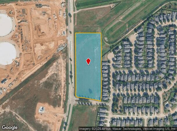
0 Ferry Rd, Katy, TX 77449
NEARBY LISTINGS FOR SALE OR LEASE
Property Detail
0 Ferry Rd
Houston-The Woodlands-Sugar Land, TX
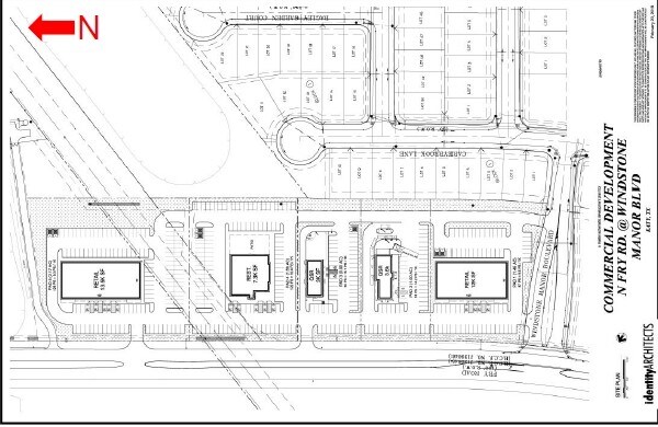
Windstone Crossing Commercial
1412810010001
RES A BLK 1 WINDSTONE CROSSING COMMERCIAL
Transportnec
Harris
X
Texas
48201C0605M
5.23 AC
2024
Katy/Grand Parkway West
2025
Houston
542202
DEMOGRAPHICS near 0 Ferry Rd
1 Mile
3 Mile
5 Mile
2024 Total Population
20,686
148,813
320,267
2029 Population
21,218
152,031
328,351
Pop Growth 2024-2029
+ 2.57%
+ 2.16%
+ 2.52%
Average Age
34
35
35
2024 Total Households
5,662
44,194
100,588
HH Growth 2024-2029
+ 2.49%
+ 2.11%
+ 2.45%
Median Household Inc
$79,784
$81,712
$80,842
Avg Household Size
3.50
3.30
3.10
2024 Avg HH Vehicles
2.00
2.00
2.00
Median Home Value
$216,224
$205,181
$223,434
Median Year Built
2004
2004
2002
Nearby Places
Map Layers
Map Styles
 Street
 Aerial
- Restaurants
- Banks
- Shops
- Fitness
- Groceries
PUBLIC TRANSPORTATION
AIRPORT
George Bush Intcntl/Houston
DRIVE
WALK
Distance
George Bush Intcntl/Houston
46 min
34.4 mi
William P Hobby
DRIVE
WALK
Distance
William P Hobby
59 min
39.3 mi
Freight Ports
Port of Houston
DRIVE
WALK
Distance
Port of Houston
52 min
36.1 mi
SALE & LEASE HISTORY
LISTING DATE
SALE/LEASE

Oct 27, 2017
For Lease
Nearby Properties
Address
Land Use
TOTAL SIZE
Lot Size
Zoning
Address
Land Use
TOTAL SIZE
Lot Size
Zoning
439,347 SF
13.50 AC
Address
Land Use
TOTAL SIZE
Lot Size
Zoning
341,844 SF
16.71 AC
Address
Land Use
TOTAL SIZE
Lot Size
Zoning
343,605 SF
11.90 AC
Address
Land Use
TOTAL SIZE
Lot Size
Zoning
323,609 SF
12.71 AC
Address
Land Use
TOTAL SIZE
Lot Size
Zoning
347,834 SF
15.25 AC
Address
Land Use
TOTAL SIZE
Lot Size
Zoning
272,033 SF
12.74 AC
Address
Land Use
TOTAL SIZE
Lot Size
Zoning
335,899 SF
12.62 AC
Address
Land Use
TOTAL SIZE
Lot Size
Zoning
331,263 SF
11.36 AC
Address
Land Use
TOTAL SIZE
Lot Size
Zoning
266,532 SF
6.45 AC
Address
Land Use
TOTAL SIZE
Lot Size
Zoning
236,406 SF
11.40 AC
Address
Land Use
TOTAL SIZE
Lot Size
Zoning
305,624 SF
Address
Land Use
TOTAL SIZE
Lot Size
Zoning
375,152 SF
19.57 AC
Address
Land Use
TOTAL SIZE
Lot Size
Zoning
262,174 SF
11.64 AC
Address
Land Use
TOTAL SIZE
Lot Size
Zoning
347,192 SF
16.10 AC
Address
Land Use
TOTAL SIZE
Lot Size
Zoning
270,000 SF
14.25 AC
Address
Land Use
TOTAL SIZE
Lot Size
Zoning
211,757 SF
9.02 AC
Address
Land Use
TOTAL SIZE
Lot Size
Zoning
171,000 SF
7.08 AC
Address
Land Use
TOTAL SIZE
Lot Size
Zoning
117,860 SF
12.44 AC
Address
Land Use
TOTAL SIZE
Lot Size
Zoning
228,152 SF
22.61 AC
Address
Land Use
TOTAL SIZE
Lot Size
Zoning
150,734 SF
29.67 AC
Address
Land Use
TOTAL SIZE
Lot Size
Zoning
119,086 SF
18.61 AC
Address
Land Use
TOTAL SIZE
Lot Size
Zoning
122,880 SF
15 AC
Address
Land Use
TOTAL SIZE
Lot Size
Zoning
146,337 SF
9.55 AC
Address
Land Use
TOTAL SIZE
Lot Size
Zoning
143,950 SF
10.30 AC
Address
Land Use
TOTAL SIZE
Lot Size
Zoning
200,616 SF
8.41 AC
Address
Land Use
TOTAL SIZE
Lot Size
Zoning
163,770 SF
5.08 AC
Address
Land Use
TOTAL SIZE
Lot Size
Zoning
144,736 SF
2.55 AC
Address
Land Use
TOTAL SIZE
Lot Size
Zoning
58,014 SF
22.85 AC
Address
Land Use
TOTAL SIZE
Lot Size
Zoning
83,750 SF
4.88 AC
Address
Land Use
TOTAL SIZE
Lot Size
Zoning
57,300 SF
7.89 AC
The World's #1 Commercial Real Estate Marketplace
Connect with us
© 2025 CoStar Group
The information above has been obtained from sources believed reliable. While we do not doubt its accuracy we have not verified it and make no guarantee, warranty or representation about it. It is your responsibility to independently confirm its accuracy and completeness. Any projections, opinions, assumptions, or estimates used are for example only and do not represent the current or future performance of the property. The value of this transaction to you depends on tax and other factors which should be evaluated by your tax, financial, and legal advisors. You and your advisors should conduct a careful, independent investigation of the property to determine to your satisfaction the suitability of the property for your needs.