Property Record
N Hamilton Rd, Columbus Grove, OH 45830

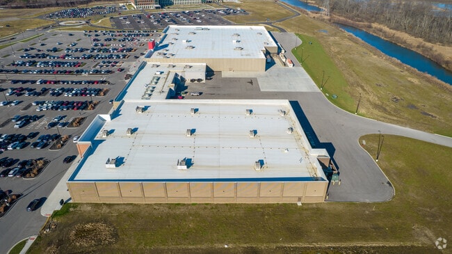
Property Detail
N Hamilton Rd
010-295521
N HAMILTON RD R16 T2 S3 8.246 ACRES
Regionalshoppingcenterormallwithanchorstore
FRANKLIN
AE The base floodplain where base flood elevations are provided. AE Zones are now used on new format FIRMs instead of A1-A30 Zones.
Ohio
2024
8.25 AC
2025
Westerville
030500
Columbus
47,240 SF
Columbus, OH
NEARBY LISTINGS FOR SALE OR LEASE
DEMOGRAPHICS near N Hamilton Rd
1 mile
3 mile
5 mile
2025 Total Population
10,586
71,058
157,661
2030 Population
11,018
73,603
162,857
Pop Growth 2025-2030
+ 4.08%
+ 3.58%
+ 3.30%
Average Age
38
40
39
2025 Total Households
4,979
31,916
65,025
HH Growth 2025-2030
+ 4.30%
+ 3.68%
+ 3.40%
Median Household Inc
$83,942
$94,765
$96,629
Avg Household Size
2.10
2.20
2.40
2025 Avg HH Vehicles
2.00
2.00
2.00
Median Home Value
$383,873
$368,993
$352,862
Median Year Built
2005
2001
1992
Nearby Places
Map Layers
Map Styles
 Street
 Aerial
Layers
 Traffic
 Biking
Places
Listings with unknown addresses are not visible on the map
- Restaurants
- Banks
- Shops
- Fitness
- Groceries
PUBLIC TRANSPORTATION
AIRPORT
John Glenn Columbus International
Drive
Walk
Distance
John Glenn Columbus International
17 min
9.0 mi
Rickenbacker International
Drive
Walk
Distance
Rickenbacker International
32 min
21.9 mi
Freight Ports
Port of Toledo
Drive
Walk
Distance
Port of Toledo
181 min
143.0 mi
Nearby Properties
Address
Land Use
TOTAL SIZE
Lot Size
Zoning
Address
Land Use
TOTAL SIZE
Lot Size
Zoning
696,736 SF
76.73 AC
Address
Land Use
TOTAL SIZE
Lot Size
Zoning
253,127 SF
31.59 AC
Address
Land Use
TOTAL SIZE
Lot Size
Zoning
186,557 SF
35.69 AC
Address
Land Use
TOTAL SIZE
Lot Size
Zoning
316,548 SF
145.20 AC
Address
Land Use
TOTAL SIZE
Lot Size
Zoning
112,126 SF
19.09 AC
Address
Land Use
TOTAL SIZE
Lot Size
Zoning
67,754 SF
37.90 AC
Address
Land Use
TOTAL SIZE
Lot Size
Zoning
25,298 SF
33.25 AC
Address
Land Use
TOTAL SIZE
Lot Size
Zoning
260,944 SF
17.30 AC
Address
Land Use
TOTAL SIZE
Lot Size
Zoning
602,448 SF
24.71 AC
Address
Land Use
TOTAL SIZE
Lot Size
Zoning
45,135 SF
22.02 AC
Address
Land Use
TOTAL SIZE
Lot Size
Zoning
47,003 SF
24.68 AC
Address
Land Use
TOTAL SIZE
Lot Size
Zoning
299,890 SF
74.80 AC
Address
Land Use
TOTAL SIZE
Lot Size
Zoning
132,276 SF
0.18 AC
Address
Land Use
TOTAL SIZE
Lot Size
Zoning
62,660 SF
41.24 AC
Address
Land Use
TOTAL SIZE
Lot Size
Zoning
195,837 SF
31.48 AC
Address
Land Use
TOTAL SIZE
Lot Size
Zoning
80,007 SF
27.54 AC
Address
Land Use
TOTAL SIZE
Lot Size
Zoning
180,968 SF
12.77 AC
Address
Land Use
TOTAL SIZE
Lot Size
Zoning
204,829 SF
37.69 AC
Address
Land Use
TOTAL SIZE
Lot Size
Zoning
94,416 SF
0.24 AC
Address
Land Use
TOTAL SIZE
Lot Size
Zoning
71,592 SF
32.42 AC
Address
Land Use
TOTAL SIZE
Lot Size
Zoning
74,620 SF
9.03 AC
Address
Land Use
TOTAL SIZE
Lot Size
Zoning
45,849 SF
29.64 AC
Address
Land Use
TOTAL SIZE
Lot Size
Zoning
144,900 SF
11.04 AC
Address
Land Use
TOTAL SIZE
Lot Size
Zoning
100,116 SF
18.80 AC
Address
Land Use
TOTAL SIZE
Lot Size
Zoning
151,892 SF
8.63 AC
Address
Land Use
TOTAL SIZE
Lot Size
Zoning
266,057 SF
26 AC
Address
Land Use
TOTAL SIZE
Lot Size
Zoning
151,935 SF
9 AC
Address
Land Use
TOTAL SIZE
Lot Size
Zoning
17,088 SF
16.31 AC
Address
Land Use
TOTAL SIZE
Lot Size
Zoning
76,096 SF
16.41 AC
Address
Land Use
TOTAL SIZE
Lot Size
Zoning
51,376 SF
12.65 AC
The World's #1 Commercial Real Estate Marketplace
Connect with us
© 2026 CoStar Group
The information above has been obtained from sources believed reliable. While we do not doubt its accuracy we have not verified it and make no guarantee, warranty or representation about it. It is your responsibility to independently confirm its accuracy and completeness. Any projections, opinions, assumptions, or estimates used are for example only and do not represent the current or future performance of the property. The value of this transaction to you depends on tax and other factors which should be evaluated by your tax, financial, and legal advisors. You and your advisors should conduct a careful, independent investigation of the property to determine to your satisfaction the suitability of the property for your needs.