Property Record
N High, Mount Orab, OH 45154
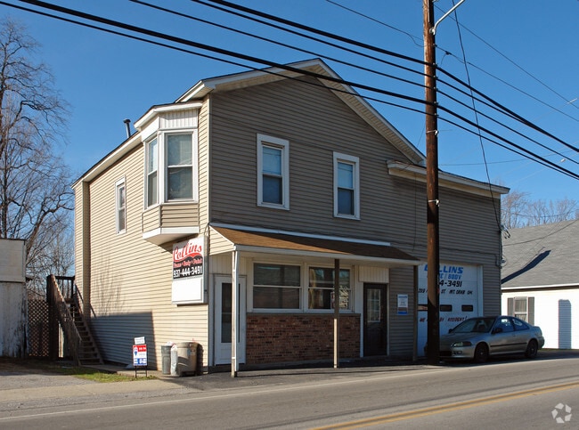
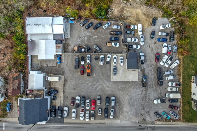
Property Detail
N High
Cincinnati, OH-KY-IN
S.2074 .19 A LANDS MT ORAB VILLAGE WESTERN BRN LSD
11-019964-0000
BROWN
Commercialacreage
Ohio
A Areas with a 1% annual chance of flooding and a 26% chance of flooding over the life of a 30-year mortgage.
0.96 AC
2024
Brown County
2024
Cincinnati/Dayton
951301
NEARBY LISTINGS FOR SALE OR LEASE
DEMOGRAPHICS near N High
1 mile
3 mile
5 mile
2025 Total Population
2,538
6,588
10,904
2030 Population
2,572
6,668
11,012
Pop Growth 2025-2030
+ 1.34%
+ 1.21%
+ 0.99%
Average Age
38
40
41
2025 Total Households
987
2,527
4,231
HH Growth 2025-2030
+ 1.42%
+ 1.19%
+ 0.97%
Median Household Inc
$66,521
$73,545
$70,337
Avg Household Size
2.60
2.60
2.60
2025 Avg HH Vehicles
2.00
2.00
2.00
Median Home Value
$242,700
$212,752
$207,500
Median Year Built
1994
1991
1990
Nearby Places
Map Layers
Map Styles
 Street
 Aerial
Transit
 Traffic
 Biking
Places
Listings with unknown addresses are not visible on the map
- Restaurants
- Banks
- Shops
- Fitness
- Groceries
SALE & LEASE HISTORY
LISTING DATE
SALE/LEASE

Nov 20, 2022
For Sale
Nearby Properties
Address
Land Use
TOTAL SIZE
Lot Size
Zoning
Address
Land Use
TOTAL SIZE
Lot Size
Zoning
27.40 AC
Address
Land Use
TOTAL SIZE
Lot Size
Zoning
44.55 AC
Address
Land Use
TOTAL SIZE
Lot Size
Zoning
54.41 AC
Address
Land Use
TOTAL SIZE
Lot Size
Zoning
Address
Land Use
TOTAL SIZE
Lot Size
Zoning
Address
Land Use
TOTAL SIZE
Lot Size
Zoning
60.01 AC
Address
Land Use
TOTAL SIZE
Lot Size
Zoning
16.99 AC
Address
Land Use
TOTAL SIZE
Lot Size
Zoning
40.27 AC
Address
Land Use
TOTAL SIZE
Lot Size
Zoning
30.63 AC
Address
Land Use
TOTAL SIZE
Lot Size
Zoning
61.03 AC
Address
Land Use
TOTAL SIZE
Lot Size
Zoning
Address
Land Use
TOTAL SIZE
Lot Size
Zoning
Address
Land Use
TOTAL SIZE
Lot Size
Zoning
4,494 SF
297.05 AC
Address
Land Use
TOTAL SIZE
Lot Size
Zoning
24,120 SF
15.82 AC
Address
Land Use
TOTAL SIZE
Lot Size
Zoning
7.05 AC
Address
Land Use
TOTAL SIZE
Lot Size
Zoning
3,956 SF
18.03 AC
Address
Land Use
TOTAL SIZE
Lot Size
Zoning
3.12 AC
Address
Land Use
TOTAL SIZE
Lot Size
Zoning
Address
Land Use
TOTAL SIZE
Lot Size
Zoning
3.47 AC
Address
Land Use
TOTAL SIZE
Lot Size
Zoning
0.97 AC
Address
Land Use
TOTAL SIZE
Lot Size
Zoning
3.17 AC
Address
Land Use
TOTAL SIZE
Lot Size
Zoning
170.69 AC
Address
Land Use
TOTAL SIZE
Lot Size
Zoning
984 SF
240.13 AC
Address
Land Use
TOTAL SIZE
Lot Size
Zoning
1.44 AC
Address
Land Use
TOTAL SIZE
Lot Size
Zoning
1.91 AC
Address
Land Use
TOTAL SIZE
Lot Size
Zoning
1.66 AC
Address
Land Use
TOTAL SIZE
Lot Size
Zoning
60.57 AC
Address
Land Use
TOTAL SIZE
Lot Size
Zoning
Address
Land Use
TOTAL SIZE
Lot Size
Zoning
1.74 AC
Address
Land Use
TOTAL SIZE
Lot Size
Zoning
0.96 AC
The World's #1 Commercial Real Estate Marketplace
Connect with us
© 2026 CoStar Group
The information above has been obtained from sources believed reliable. While we do not doubt its accuracy we have not verified it and make no guarantee, warranty or representation about it. It is your responsibility to independently confirm its accuracy and completeness. Any projections, opinions, assumptions, or estimates used are for example only and do not represent the current or future performance of the property. The value of this transaction to you depends on tax and other factors which should be evaluated by your tax, financial, and legal advisors. You and your advisors should conduct a careful, independent investigation of the property to determine to your satisfaction the suitability of the property for your needs.