Property Record
N Highway 17, Mt Pleasant, SC 29429


Save to a Folder
{{folder.Name}}
{{folder.ListingIds.length}} Properties
{{folder.ListingIds.length}} Property
Create a New Folder
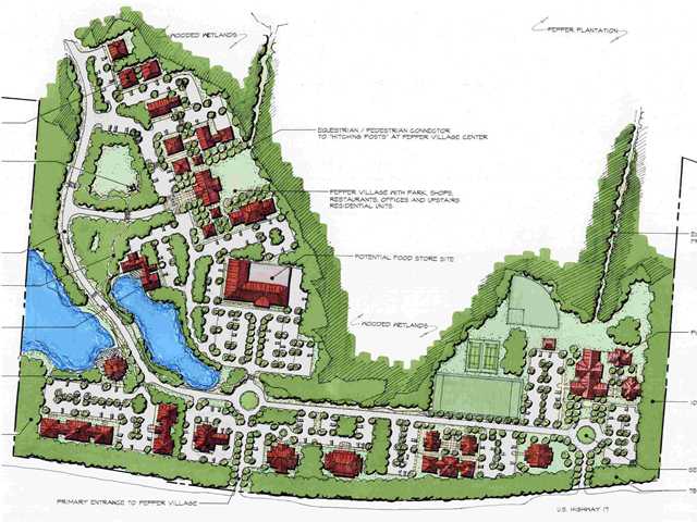
Property Detail
N Highway 17
615-00-00-044
MAPPLATB L23 MAPPLATP 0440 SUBDIVISIONNAME PEPPER PLANTATION TRACT B RESIDUAL
Agriculturalland
CHARLESTON
B and X Area of moderate flood hazard, usually the area between the limits of the 100-year and 500-year floods.
South Carolina
2025
73.81 AC
2024
East Islands/Mt Pleasant
005002
Charleston/N Charleston
632 SF
Charleston-North Charleston, SC
NEARBY LISTINGS FOR SALE OR LEASE
DEMOGRAPHICS near N Highway 17
1 mile
3 mile
5 mile
2025 Total Population
2,595
18,897
39,160
2030 Population
2,729
19,735
40,722
Pop Growth 2025-2030
+ 5.16%
+ 4.43%
+ 3.99%
Average Age
42
41
42
2025 Total Households
914
6,926
14,341
HH Growth 2025-2030
+ 5.36%
+ 4.39%
+ 4.00%
Median Household Inc
$161,666
$131,250
$125,640
Avg Household Size
2.80
2.70
2.70
2025 Avg HH Vehicles
2.00
2.00
2.00
Median Home Value
$726,098
$703,577
$737,073
Median Year Built
2010
2008
2005
Nearby Places
Map Layers
Map Styles
 Street
 Aerial
Layers
 Traffic
 Biking
Places
Listings with unknown addresses are not visible on the map
- Restaurants
- Banks
- Shops
- Fitness
- Groceries
PUBLIC TRANSPORTATION
AIRPORT
Charleston AFB/International
Drive
Walk
Distance
Charleston AFB/International
39 min
25.3 mi
Freight Ports
Wando Welch Terminal
Drive
Walk
Distance
Wando Welch Terminal
18 min
10.0 mi
SALE & LEASE HISTORY
LISTING DATE
SALE/LEASE

Sep 24, 2016
For Sale
Oct 06, 2017
For Sale
Mar 29, 2017
For Sale
Mar 16, 2017
For Sale
Nearby Properties
Address
Land Use
TOTAL SIZE
Lot Size
Zoning
Address
Land Use
TOTAL SIZE
Lot Size
Zoning
19.70 AC
Address
Land Use
TOTAL SIZE
Lot Size
Zoning
20.24 AC
Address
Land Use
TOTAL SIZE
Lot Size
Zoning
Address
Land Use
TOTAL SIZE
Lot Size
Zoning
9.11 AC
Address
Land Use
TOTAL SIZE
Lot Size
Zoning
6,622 SF
20.06 AC
Address
Land Use
TOTAL SIZE
Lot Size
Zoning
2,646 SF
16.35 AC
Address
Land Use
TOTAL SIZE
Lot Size
Zoning
Address
Land Use
TOTAL SIZE
Lot Size
Zoning
Address
Land Use
TOTAL SIZE
Lot Size
Zoning
1,104 SF
13.70 AC
Address
Land Use
TOTAL SIZE
Lot Size
Zoning
5,209 SF
5.88 AC
Address
Land Use
TOTAL SIZE
Lot Size
Zoning
12.60 AC
Address
Land Use
TOTAL SIZE
Lot Size
Zoning
45,969 SF
10.76 AC
Address
Land Use
TOTAL SIZE
Lot Size
Zoning
Address
Land Use
TOTAL SIZE
Lot Size
Zoning
Address
Land Use
TOTAL SIZE
Lot Size
Zoning
9.81 AC
Address
Land Use
TOTAL SIZE
Lot Size
Zoning
38,788 SF
10.28 AC
Address
Land Use
TOTAL SIZE
Lot Size
Zoning
Address
Land Use
TOTAL SIZE
Lot Size
Zoning
5.69 AC
Address
Land Use
TOTAL SIZE
Lot Size
Zoning
60.82 AC
Address
Land Use
TOTAL SIZE
Lot Size
Zoning
1,020 SF
7.40 AC
Address
Land Use
TOTAL SIZE
Lot Size
Zoning
7,552 SF
2.84 AC
Address
Land Use
TOTAL SIZE
Lot Size
Zoning
32.65 AC
Address
Land Use
TOTAL SIZE
Lot Size
Zoning
1,544 SF
1.41 AC
Address
Land Use
TOTAL SIZE
Lot Size
Zoning
3.17 AC
Address
Land Use
TOTAL SIZE
Lot Size
Zoning
19,130 SF
3.45 AC
Address
Land Use
TOTAL SIZE
Lot Size
Zoning
949 SF
4.82 AC
Address
Land Use
TOTAL SIZE
Lot Size
Zoning
6,300 SF
360.79 AC
Address
Land Use
TOTAL SIZE
Lot Size
Zoning
6,600 SF
3.07 AC
Address
Land Use
TOTAL SIZE
Lot Size
Zoning
18,730 SF
3.58 AC
Address
Land Use
TOTAL SIZE
Lot Size
Zoning
The World's #1 Commercial Real Estate Marketplace
Connect with us
© 2026 CoStar Group
The information above has been obtained from sources believed reliable. While we do not doubt its accuracy we have not verified it and make no guarantee, warranty or representation about it. It is your responsibility to independently confirm its accuracy and completeness. Any projections, opinions, assumptions, or estimates used are for example only and do not represent the current or future performance of the property. The value of this transaction to you depends on tax and other factors which should be evaluated by your tax, financial, and legal advisors. You and your advisors should conduct a careful, independent investigation of the property to determine to your satisfaction the suitability of the property for your needs.