Property Record
N Highway 17, Mt Pleasant, SC 29466

NEARBY LISTINGS FOR SALE OR LEASE
Property Detail
N Highway 17
Charleston-North Charleston, SC
Ten Mile
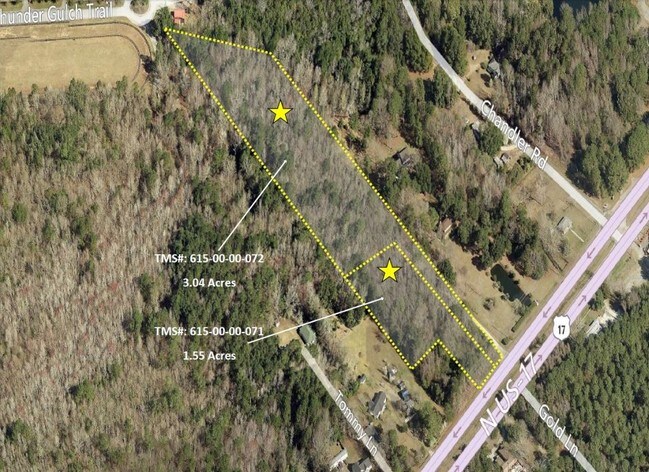
615-00-00-072
SUBDIVISION NAME -TEN MILE DESCRIPTION -LOT 3 SITE NAME -N W SIDE APPROX 520 FT W PARADISE ISL RD
Commercialacreage
Charleston
X
South Carolina
45019C0365K
3
2025
3.04 AC
2024
East Islands/Mt Pleasant
004618
Charleston/N Charleston
DEMOGRAPHICS near N Highway 17
1 Mile
3 Mile
5 Mile
2024 Total Population
2,159
15,365
35,769
2029 Population
2,352
16,497
38,285
Pop Growth 2024-2029
+ 8.94%
+ 7.37%
+ 7.03%
Average Age
42
41
42
2024 Total Households
752
5,610
13,134
HH Growth 2024-2029
+ 8.91%
+ 7.13%
+ 6.87%
Median Household Inc
$111,890
$112,804
$103,724
Avg Household Size
2.90
2.70
2.70
2024 Avg HH Vehicles
2.00
2.00
2.00
Median Home Value
$553,430
$520,349
$511,879
Median Year Built
2010
2007
2005
Nearby Places
Map Layers
Map Styles
 Street
 Aerial
- Restaurants
- Banks
- Shops
- Fitness
- Groceries
PUBLIC TRANSPORTATION
AIRPORT
Charleston AFB/International
DRIVE
WALK
Distance
Charleston AFB/International
37 min
25.3 mi
Freight Ports
Wando Welch Terminal
DRIVE
WALK
Distance
Wando Welch Terminal
16 min
10.0 mi
Nearby Properties
Address
Land Use
TOTAL SIZE
Lot Size
Zoning
Address
Land Use
TOTAL SIZE
Lot Size
Zoning
19.70 AC
Address
Land Use
TOTAL SIZE
Lot Size
Zoning
20.24 AC
Address
Land Use
TOTAL SIZE
Lot Size
Zoning
Address
Land Use
TOTAL SIZE
Lot Size
Zoning
9.11 AC
Address
Land Use
TOTAL SIZE
Lot Size
Zoning
2,646 SF
16.35 AC
Address
Land Use
TOTAL SIZE
Lot Size
Zoning
Address
Land Use
TOTAL SIZE
Lot Size
Zoning
Address
Land Use
TOTAL SIZE
Lot Size
Zoning
5,209 SF
5.88 AC
Address
Land Use
TOTAL SIZE
Lot Size
Zoning
12.60 AC
Address
Land Use
TOTAL SIZE
Lot Size
Zoning
45,969 SF
10.76 AC
Address
Land Use
TOTAL SIZE
Lot Size
Zoning
Address
Land Use
TOTAL SIZE
Lot Size
Zoning
9.81 AC
Address
Land Use
TOTAL SIZE
Lot Size
Zoning
38,788 SF
10.28 AC
Address
Land Use
TOTAL SIZE
Lot Size
Zoning
Address
Land Use
TOTAL SIZE
Lot Size
Zoning
5.69 AC
Address
Land Use
TOTAL SIZE
Lot Size
Zoning
60.82 AC
Address
Land Use
TOTAL SIZE
Lot Size
Zoning
1,020 SF
7.40 AC
Address
Land Use
TOTAL SIZE
Lot Size
Zoning
7,552 SF
2.84 AC
Address
Land Use
TOTAL SIZE
Lot Size
Zoning
32.65 AC
Address
Land Use
TOTAL SIZE
Lot Size
Zoning
1,544 SF
1.41 AC
Address
Land Use
TOTAL SIZE
Lot Size
Zoning
3.17 AC
Address
Land Use
TOTAL SIZE
Lot Size
Zoning
19,130 SF
3.45 AC
Address
Land Use
TOTAL SIZE
Lot Size
Zoning
949 SF
4.82 AC
Address
Land Use
TOTAL SIZE
Lot Size
Zoning
6,300 SF
360.79 AC
Address
Land Use
TOTAL SIZE
Lot Size
Zoning
6,600 SF
3.07 AC
Address
Land Use
TOTAL SIZE
Lot Size
Zoning
18,730 SF
3.58 AC
Address
Land Use
TOTAL SIZE
Lot Size
Zoning
1,320 SF
Address
Land Use
TOTAL SIZE
Lot Size
Zoning
Address
Land Use
TOTAL SIZE
Lot Size
Zoning
1,485 SF
5.26 AC
Address
Land Use
TOTAL SIZE
Lot Size
Zoning
29,376 SF
2.09 AC
The World's #1 Commercial Real Estate Marketplace
Connect with us
© 2026 CoStar Group
The information above has been obtained from sources believed reliable. While we do not doubt its accuracy we have not verified it and make no guarantee, warranty or representation about it. It is your responsibility to independently confirm its accuracy and completeness. Any projections, opinions, assumptions, or estimates used are for example only and do not represent the current or future performance of the property. The value of this transaction to you depends on tax and other factors which should be evaluated by your tax, financial, and legal advisors. You and your advisors should conduct a careful, independent investigation of the property to determine to your satisfaction the suitability of the property for your needs.