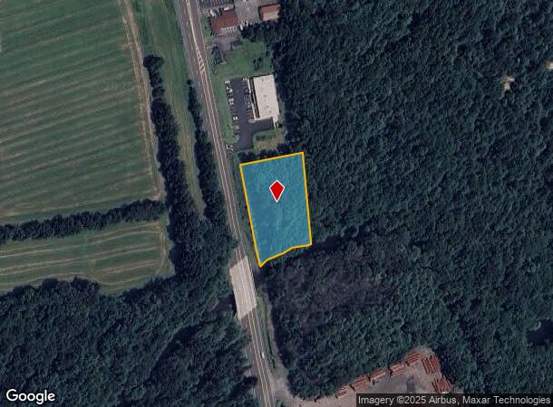
Property Record
309 N Route 309 Hwy, Drums, PA 18222
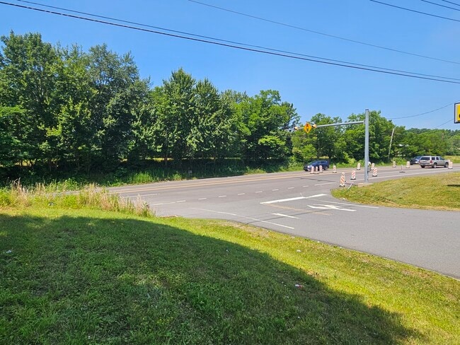

This Property Is For Sale
NEARBY LISTINGS FOR SALE OR LEASE
Property Detail
309 N Route 309 Hwy
Scranton--Wilkes-Barre--Hazelton, PA
6-806-D1-1-D1-R1-4 ROUTE 00309
06-Q8S3-001-007-000
Luzerne
Residentialacreage
Pennsylvania
AE
7
42079C0512E
1.31 AC
2025
I-81 Corridor
2025
Philadelphia
216601
DEMOGRAPHICS near 309 N Route 309 Hwy
1 Mile
3 Mile
5 Mile
2024 Total Population
1,754
9,397
25,565
2029 Population
1,768
9,511
25,496
Pop Growth 2024-2029
+ 0.80%
+ 1.21%
(0.27%)
Average Age
43
44
43
2024 Total Households
708
3,917
10,555
HH Growth 2024-2029
+ 0.71%
+ 1.25%
(0.26%)
Median Household Inc
$99,097
$89,312
$72,037
Avg Household Size
2.40
2.30
2.30
2024 Avg HH Vehicles
2.00
2.00
2.00
Median Home Value
$167,465
$180,711
$170,384
Median Year Built
1992
1987
1973
Nearby Places
Map Layers
Map Styles
 Street
 Aerial
- Restaurants
- Banks
- Shops
- Fitness
- Groceries
PUBLIC TRANSPORTATION
AIRPORT
Wilkes-Barre/Scranton International
DRIVE
WALK
Distance
Wilkes-Barre/Scranton International
39 min
27.3 mi
Freight Ports
Port of Philadelphia
DRIVE
WALK
Distance
Port of Philadelphia
132 min
110.7 mi
Nearby Properties
Address
Land Use
TOTAL SIZE
Lot Size
Zoning
Address
Land Use
TOTAL SIZE
Lot Size
Zoning
529.84 AC
Address
Land Use
TOTAL SIZE
Lot Size
Zoning
3.95 AC
Address
Land Use
TOTAL SIZE
Lot Size
Zoning
2,171 SF
366.98 AC
Address
Land Use
TOTAL SIZE
Lot Size
Zoning
7.42 AC
Address
Land Use
TOTAL SIZE
Lot Size
Zoning
8.42 AC
Address
Land Use
TOTAL SIZE
Lot Size
Zoning
5.03 AC
Address
Land Use
TOTAL SIZE
Lot Size
Zoning
8.40 AC
Address
Land Use
TOTAL SIZE
Lot Size
Zoning
8.56 AC
Address
Land Use
TOTAL SIZE
Lot Size
Zoning
3.31 AC
Address
Land Use
TOTAL SIZE
Lot Size
Zoning
12.29 AC
Address
Land Use
TOTAL SIZE
Lot Size
Zoning
7.42 AC
Address
Land Use
TOTAL SIZE
Lot Size
Zoning
12.83 AC
Address
Land Use
TOTAL SIZE
Lot Size
Zoning
32.99 AC
Address
Land Use
TOTAL SIZE
Lot Size
Zoning
10.46 AC
Address
Land Use
TOTAL SIZE
Lot Size
Zoning
73.44 AC
Address
Land Use
TOTAL SIZE
Lot Size
Zoning
162.30 AC
Address
Land Use
TOTAL SIZE
Lot Size
Zoning
10 AC
Address
Land Use
TOTAL SIZE
Lot Size
Zoning
6.54 AC
Address
Land Use
TOTAL SIZE
Lot Size
Zoning
1.30 AC
Address
Land Use
TOTAL SIZE
Lot Size
Zoning
5.02 AC
Address
Land Use
TOTAL SIZE
Lot Size
Zoning
5.51 AC
Address
Land Use
TOTAL SIZE
Lot Size
Zoning
0.58 AC
Address
Land Use
TOTAL SIZE
Lot Size
Zoning
6.94 AC
Address
Land Use
TOTAL SIZE
Lot Size
Zoning
0.68 AC
Address
Land Use
TOTAL SIZE
Lot Size
Zoning
1.46 AC
Address
Land Use
TOTAL SIZE
Lot Size
Zoning
0.89 AC
Address
Land Use
TOTAL SIZE
Lot Size
Zoning
3.31 AC
Address
Land Use
TOTAL SIZE
Lot Size
Zoning
242.71 AC
Address
Land Use
TOTAL SIZE
Lot Size
Zoning
853.86 AC
Address
Land Use
TOTAL SIZE
Lot Size
Zoning
0.55 AC
The World's #1 Commercial Real Estate Marketplace
Connect with us
© 2025 CoStar Group
The information above has been obtained from sources believed reliable. While we do not doubt its accuracy we have not verified it and make no guarantee, warranty or representation about it. It is your responsibility to independently confirm its accuracy and completeness. Any projections, opinions, assumptions, or estimates used are for example only and do not represent the current or future performance of the property. The value of this transaction to you depends on tax and other factors which should be evaluated by your tax, financial, and legal advisors. You and your advisors should conduct a careful, independent investigation of the property to determine to your satisfaction the suitability of the property for your needs.