Property Record
N Ift 2014-456, Williamston, MI 48895
Property Detail
N Ift 2014-456
43-08-95-000-034
IFT #2014-456 REAL PROPERTY TOTAL PROJECT = 9 231 266 6 MILLS FOR SET TCV SEV/TV 2015 4,707,946 2,354,000 = 51% TCV DONE '15
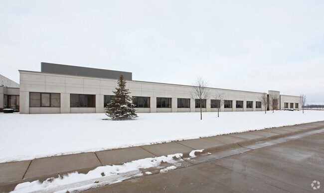
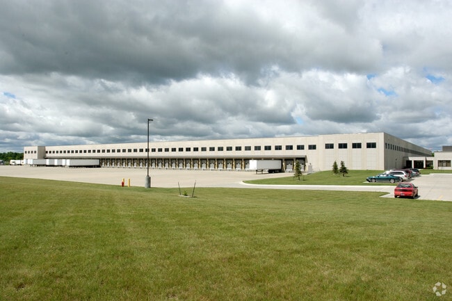
Distributionwarehouseregional
INGHAM
B and X Area of moderate flood hazard, usually the area between the limits of the 100-year and 500-year floods.
Michigan
2024
Williamston/Weberville
2025
West Michigan
005800
Lansing-East Lansing, MI
61,370 SF
NEARBY LISTINGS FOR SALE OR LEASE
-
-
View all Williamston listings for sale on LoopNet.com
DEMOGRAPHICS near N Ift 2014-456
1 mile
3 mile
5 mile
2025 Total Population
108
3,351
11,663
2030 Population
108
3,397
11,805
Pop Growth 2025-2030
0.00%
+ 1.37%
+ 1.22%
Average Age
41
40
41
2025 Total Households
41
1,289
4,476
HH Growth 2025-2030
0.00%
+ 1.47%
+ 1.30%
Median Household Inc
$146,874
$82,949
$88,737
Avg Household Size
2.60
2.60
2.60
2025 Avg HH Vehicles
3.00
2.00
2.00
Median Home Value
$299,999
$177,702
$236,555
Median Year Built
1976
1975
1984
Nearby Places
Map Layers
Map Styles
 Street
 Aerial
Layers
 Traffic
 Biking
Places
Listings with unknown addresses are not visible on the map
- Restaurants
- Banks
- Shops
- Fitness
- Groceries
PUBLIC TRANSPORTATION
AIRPORT
Capital Region International
Drive
Walk
Distance
Capital Region International
35 min
23.4 mi
Freight Ports
Port of Toledo
Drive
Walk
Distance
Port of Toledo
132 min
109.1 mi
Nearby Properties
Address
Land Use
TOTAL SIZE
Lot Size
Zoning
Address
Land Use
TOTAL SIZE
Lot Size
Zoning
75,760 SF
105.10 AC
I-1
Address
Land Use
TOTAL SIZE
Lot Size
Zoning
9,700 SF
45 AC
I-2
Address
Land Use
TOTAL SIZE
Lot Size
Zoning
75,760 SF
37.51 AC
I-1
Address
Land Use
TOTAL SIZE
Lot Size
Zoning
153,984 SF
12.03 AC
I-2
Address
Land Use
TOTAL SIZE
Lot Size
Zoning
63.34 AC
I-1
Address
Land Use
TOTAL SIZE
Lot Size
Zoning
48,846 SF
0.97 AC
C-1
Address
Land Use
TOTAL SIZE
Lot Size
Zoning
9,260 SF
0.58 AC
R-3
Address
Land Use
TOTAL SIZE
Lot Size
Zoning
23,184 SF
5.92 AC
B-2
Address
Land Use
TOTAL SIZE
Lot Size
Zoning
21,294 SF
4.02 AC
C-2
Address
Land Use
TOTAL SIZE
Lot Size
Zoning
8,544 SF
7.16 AC
C-2
Address
Land Use
TOTAL SIZE
Lot Size
Zoning
37,347 SF
16.98 AC
C-2
Address
Land Use
TOTAL SIZE
Lot Size
Zoning
34,769 SF
2.02 AC
C-1
Address
Land Use
TOTAL SIZE
Lot Size
Zoning
13,016 SF
4.69 AC
R-3
Address
Land Use
TOTAL SIZE
Lot Size
Zoning
13,680 SF
3.83 AC
R-3
Address
Land Use
TOTAL SIZE
Lot Size
Zoning
120.08 AC
AG-SF
Address
Land Use
TOTAL SIZE
Lot Size
Zoning
1,920 SF
30 AC
MH
Address
Land Use
TOTAL SIZE
Lot Size
Zoning
10,140 SF
2.58 AC
I-2
Address
Land Use
TOTAL SIZE
Lot Size
Zoning
5,720 SF
0.76 AC
PO-1
Address
Land Use
TOTAL SIZE
Lot Size
Zoning
7,964 SF
7.84 AC
B-2
Address
Land Use
TOTAL SIZE
Lot Size
Zoning
2,100 SF
3.01 AC
I-1
Address
Land Use
TOTAL SIZE
Lot Size
Zoning
9,260 SF
0.58 AC
Address
Land Use
TOTAL SIZE
Lot Size
Zoning
226.80 AC
A-1
Address
Land Use
TOTAL SIZE
Lot Size
Zoning
14,598 SF
1.76 AC
C-2
Address
Land Use
TOTAL SIZE
Lot Size
Zoning
200 AC
A-2
Address
Land Use
TOTAL SIZE
Lot Size
Zoning
6,068 SF
3.15 AC
PO-1
Address
Land Use
TOTAL SIZE
Lot Size
Zoning
195.02 AC
A-1
Address
Land Use
TOTAL SIZE
Lot Size
Zoning
10,418 SF
39.90 AC
R-1
Address
Land Use
TOTAL SIZE
Lot Size
Zoning
10,488 SF
1.51 AC
C-3
Address
Land Use
TOTAL SIZE
Lot Size
Zoning
151.50 AC
AG-SF
The World's #1 Commercial Real Estate Marketplace
Connect with us
© 2026 CoStar Group
The information above has been obtained from sources believed reliable. While we do not doubt its accuracy we have not verified it and make no guarantee, warranty or representation about it. It is your responsibility to independently confirm its accuracy and completeness. Any projections, opinions, assumptions, or estimates used are for example only and do not represent the current or future performance of the property. The value of this transaction to you depends on tax and other factors which should be evaluated by your tax, financial, and legal advisors. You and your advisors should conduct a careful, independent investigation of the property to determine to your satisfaction the suitability of the property for your needs.