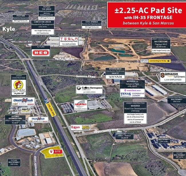
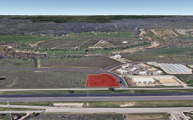
Property Record
N Ih 35, San Marcos, TX

Current Lease Availabilities
Property Detail
N Ih 35
Austin
BLANCO RIVERWALK, BLOCK B, LOT PT 1, ACRES 2.248
Austin-Round Rock-San Marcos, TX
HAYS
R190474
Texas
Residentialacreage
1
2024
2.25 AC
2025
Hays County
NEARBY LISTINGS FOR SALE OR LEASE
DEMOGRAPHICS near N Ih 35
1 mile
3 mile
5 mile
2024 Total Population
2,947
28,741
89,654
2029 Population
3,893
36,903
113,633
Pop Growth 2024-2029
+ 32.10%
+ 28.40%
+ 26.75%
Average Age
32
31
32
2024 Total Households
1,015
11,430
32,559
HH Growth 2024-2029
+ 33.10%
+ 28.51%
+ 28.18%
Median Household Inc
$39,757
$38,881
$45,998
Avg Household Size
2.80
2.40
2.50
2024 Avg HH Vehicles
2.00
2.00
2.00
Median Home Value
$269,374
$292,552
$257,967
Median Year Built
2011
2007
2004
Nearby Places
Map Layers
Map Styles
 Street
 Aerial
Transit
 Traffic
 Biking
Places
Listings with unknown addresses are not visible on the map
- Restaurants
- Banks
- Shops
- Fitness
- Groceries
PUBLIC TRANSPORTATION
COMMUTER RAIL
San Marcos Amtrak (Texas Eagle - Amtrak)
Drive
Walk
Distance
San Marcos Amtrak (Texas Eagle - Amtrak)
9 min
5.6 mi
AIRPORT
Austin-Bergstrom International
Drive
Walk
Distance
Austin-Bergstrom International
46 min
34.7 mi
Freight Ports
Calhoun Port
Drive
Walk
Distance
Calhoun Port
167 min
138.1 mi
Nearby Properties
Address
Land Use
TOTAL SIZE
Lot Size
Zoning
Address
Land Use
TOTAL SIZE
Lot Size
Zoning
1,647,300 SF
96.81 AC
Address
Land Use
TOTAL SIZE
Lot Size
Zoning
40.48 AC
Address
Land Use
TOTAL SIZE
Lot Size
Zoning
324,430 SF
23.60 AC
Address
Land Use
TOTAL SIZE
Lot Size
Zoning
479,270 SF
24.78 AC
Address
Land Use
TOTAL SIZE
Lot Size
Zoning
301,745 SF
16.14 AC
Address
Land Use
TOTAL SIZE
Lot Size
Zoning
264,570 SF
14.23 AC
Address
Land Use
TOTAL SIZE
Lot Size
Zoning
354,670 SF
13 AC
Address
Land Use
TOTAL SIZE
Lot Size
Zoning
278,193 SF
17.44 AC
Address
Land Use
TOTAL SIZE
Lot Size
Zoning
365,750 SF
19.65 AC
Address
Land Use
TOTAL SIZE
Lot Size
Zoning
306,818 SF
18.33 AC
Address
Land Use
TOTAL SIZE
Lot Size
Zoning
215,696 SF
28.15 AC
Address
Land Use
TOTAL SIZE
Lot Size
Zoning
215,688 SF
10.36 AC
Address
Land Use
TOTAL SIZE
Lot Size
Zoning
300,779 SF
10.84 AC
Address
Land Use
TOTAL SIZE
Lot Size
Zoning
193,192 SF
18.45 AC
Address
Land Use
TOTAL SIZE
Lot Size
Zoning
248,868 SF
17.77 AC
Address
Land Use
TOTAL SIZE
Lot Size
Zoning
4,173 SF
128.50 AC
Address
Land Use
TOTAL SIZE
Lot Size
Zoning
185,184 SF
11.22 AC
Address
Land Use
TOTAL SIZE
Lot Size
Zoning
233,640 SF
12.99 AC
Address
Land Use
TOTAL SIZE
Lot Size
Zoning
191,304 SF
11.25 AC
Address
Land Use
TOTAL SIZE
Lot Size
Zoning
248,850 SF
19.33 AC
Address
Land Use
TOTAL SIZE
Lot Size
Zoning
247,836 SF
19.42 AC
Address
Land Use
TOTAL SIZE
Lot Size
Zoning
181,154 SF
10.64 AC
Address
Land Use
TOTAL SIZE
Lot Size
Zoning
175,131 SF
12.24 AC
Address
Land Use
TOTAL SIZE
Lot Size
Zoning
138,522 SF
7.95 AC
Address
Land Use
TOTAL SIZE
Lot Size
Zoning
132,825 SF
52.74 AC
Address
Land Use
TOTAL SIZE
Lot Size
Zoning
203,840 SF
16.70 AC
Address
Land Use
TOTAL SIZE
Lot Size
Zoning
6.61 AC
Address
Land Use
TOTAL SIZE
Lot Size
Zoning
229,600 SF
16.50 AC
Address
Land Use
TOTAL SIZE
Lot Size
Zoning
36,219 SF
18.14 AC
Address
Land Use
TOTAL SIZE
Lot Size
Zoning
89,700 SF
3.31 AC
The World's #1 Commercial Real Estate Marketplace
Connect with us
© 2026 CoStar Group
The information above has been obtained from sources believed reliable. While we do not doubt its accuracy we have not verified it and make no guarantee, warranty or representation about it. It is your responsibility to independently confirm its accuracy and completeness. Any projections, opinions, assumptions, or estimates used are for example only and do not represent the current or future performance of the property. The value of this transaction to you depends on tax and other factors which should be evaluated by your tax, financial, and legal advisors. You and your advisors should conduct a careful, independent investigation of the property to determine to your satisfaction the suitability of the property for your needs.