Property Record
N Ih 35, Waco, TX 76705
NEARBY LISTINGS FOR SALE OR LEASE
Property Detail
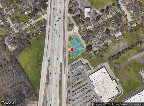
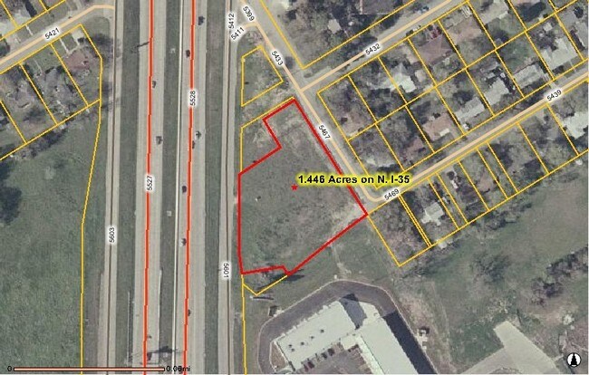
N Ih 35
Waco, TX
Brame Tract
28-007000-006300-8
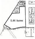
BRAME TRACT LOT 34B BLOCK B ACRES 1.186
Commercialacreage
Mclennan
X
Texas
48309C0380D
34b
2024
1.19 AC
2025
Waco & Killeen
001600
Other Market Areas
DEMOGRAPHICS near N Ih 35
1 Mile
3 Mile
5 Mile
2024 Total Population
6,635
36,843
107,367
2029 Population
7,149
39,611
114,648
Pop Growth 2024-2029
+ 7.75%
+ 7.51%
+ 6.78%
Average Age
36
35
34
2024 Total Households
2,298
13,619
38,560
HH Growth 2024-2029
+ 7.88%
+ 7.85%
+ 7.22%
Median Household Inc
$41,211
$38,499
$38,526
Avg Household Size
2.80
2.50
2.50
2024 Avg HH Vehicles
2.00
2.00
2.00
Median Home Value
$100,408
$125,875
$124,685
Median Year Built
1978
1979
1974
Nearby Places
Map Layers
Map Styles
 Street
 Aerial
- Restaurants
- Banks
- Shops
- Fitness
- Groceries
PUBLIC TRANSPORTATION
AIRPORT
Waco Regional
DRIVE
WALK
Distance
Waco Regional
21 min
10.2 mi
Freight Ports
Port of Houston
DRIVE
WALK
Distance
Port of Houston
215 min
186.6 mi
Nearby Properties
Address
Land Use
TOTAL SIZE
Lot Size
Zoning
Address
Land Use
TOTAL SIZE
Lot Size
Zoning
93.17 AC
2007 TIF
Address
Land Use
TOTAL SIZE
Lot Size
Zoning
549,274 SF
34.05 AC
O2
Address
Land Use
TOTAL SIZE
Lot Size
Zoning
120,623 SF
55.15 AC
2007 TIF
Address
Land Use
TOTAL SIZE
Lot Size
Zoning
394,674 SF
21.31 AC
O2
Address
Land Use
TOTAL SIZE
Lot Size
Zoning
27.28 AC
C
Address
Land Use
TOTAL SIZE
Lot Size
Zoning
24.75 AC
O2
Address
Land Use
TOTAL SIZE
Lot Size
Zoning
213,814 SF
7.05 AC
2007 TIF
Address
Land Use
TOTAL SIZE
Lot Size
Zoning
69,809 SF
8.12 AC
2007 TIF
Address
Land Use
TOTAL SIZE
Lot Size
Zoning
3,096 SF
51.73 AC
2007 TIF
Address
Land Use
TOTAL SIZE
Lot Size
Zoning
126,592 SF
5.05 AC
2007 TIF
Address
Land Use
TOTAL SIZE
Lot Size
Zoning
188,746 SF
1.14 AC
O2
Address
Land Use
TOTAL SIZE
Lot Size
Zoning
188,465 SF
5.85 AC
2007 TIF
Address
Land Use
TOTAL SIZE
Lot Size
Zoning
Address
Land Use
TOTAL SIZE
Lot Size
Zoning
193,780 SF
14.12 AC
C
Address
Land Use
TOTAL SIZE
Lot Size
Zoning
107,925 SF
2.20 AC
2007TIF
Address
Land Use
TOTAL SIZE
Lot Size
Zoning
16.78 AC
2007 TIF
Address
Land Use
TOTAL SIZE
Lot Size
Zoning
200,951 SF
7.09 AC
R-3E
Address
Land Use
TOTAL SIZE
Lot Size
Zoning
155,900 SF
2.85 AC
O2
Address
Land Use
TOTAL SIZE
Lot Size
Zoning
30.89 AC
R1
Address
Land Use
TOTAL SIZE
Lot Size
Zoning
206,113 SF
7.33 AC
2007TIF
Address
Land Use
TOTAL SIZE
Lot Size
Zoning
33,442 SF
2.80 AC
Address
Land Use
TOTAL SIZE
Lot Size
Zoning
3.29 AC
2007 TIF
Address
Land Use
TOTAL SIZE
Lot Size
Zoning
21.14 AC
2007 TIF
Address
Land Use
TOTAL SIZE
Lot Size
Zoning
5.57 AC
2007 TIF
Address
Land Use
TOTAL SIZE
Lot Size
Zoning
84,139 SF
2.81 AC
2007 TIF
Address
Land Use
TOTAL SIZE
Lot Size
Zoning
124,525 SF
4.17 AC
O2
Address
Land Use
TOTAL SIZE
Lot Size
Zoning
34,048 SF
6.28 AC
Address
Land Use
TOTAL SIZE
Lot Size
Zoning
117,646 SF
3.88 AC
2007 TIF
Address
Land Use
TOTAL SIZE
Lot Size
Zoning
51,175 SF
9.48 AC
2007 TIF
Address
Land Use
TOTAL SIZE
Lot Size
Zoning
186,588 SF
10.28 AC
C1
The World's #1 Commercial Real Estate Marketplace
Connect with us
© 2026 CoStar Group
The information above has been obtained from sources believed reliable. While we do not doubt its accuracy we have not verified it and make no guarantee, warranty or representation about it. It is your responsibility to independently confirm its accuracy and completeness. Any projections, opinions, assumptions, or estimates used are for example only and do not represent the current or future performance of the property. The value of this transaction to you depends on tax and other factors which should be evaluated by your tax, financial, and legal advisors. You and your advisors should conduct a careful, independent investigation of the property to determine to your satisfaction the suitability of the property for your needs.