Property Record
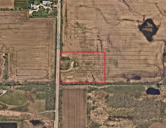
N Il Route 47, Huntley, IL 60142


This Property Is For Sale
NEARBY LISTINGS FOR SALE OR LEASE
Property Detail
N Il Route 47
18-16-200-004
DOC 2013R0038953 PC 650FT X 812.05FT SW1/4 NE1/4
Farms
McHenry
AE
Illinois
17111C0308J
12.12 AC
2024
Far Northwest
2024
Chicago
871501
Chicago-Naperville-Elgin, IL-IN-WI
DEMOGRAPHICS near N Il Route 47
1 Mile
3 Mile
5 Mile
2024 Total Population
3,385
34,041
89,000
2029 Population
3,422
34,084
89,031
Pop Growth 2024-2029
+ 1.09%
+ 0.13%
+ 0.03%
Average Age
35
36
41
2024 Total Households
1,024
10,567
31,951
HH Growth 2024-2029
+ 1.17%
+ 0.15%
+ 0.03%
Median Household Inc
$124,206
$124,894
$99,159
Avg Household Size
3.30
3.20
2.70
2024 Avg HH Vehicles
2.00
2.00
2.00
Median Home Value
$322,954
$293,355
$282,195
Median Year Built
2007
2000
1997
Nearby Places
Map Layers
Map Styles
 Street
 Aerial
- Restaurants
- Banks
- Shops
- Fitness
- Groceries
PUBLIC TRANSPORTATION
COMMUTER RAIL
Crystal Lake Station (Union Pacific Northwest Line - Northeast Illinois Regional Commuter Railroad (Metra))
DRIVE
WALK
Distance
Crystal Lake Station (Union Pacific Northwest Line - Northeast Illinois Regional Commuter Railroad (Metra))
14 min
8.4 mi
Freight Ports
Port Milwaukee
DRIVE
WALK
Distance
Port Milwaukee
106 min
75.7 mi
Nearby Properties
Address
Land Use
TOTAL SIZE
Lot Size
Zoning
Address
Land Use
TOTAL SIZE
Lot Size
Zoning
7.26 AC
Address
Land Use
TOTAL SIZE
Lot Size
Zoning
11.86 AC
Address
Land Use
TOTAL SIZE
Lot Size
Zoning
3.50 AC
Address
Land Use
TOTAL SIZE
Lot Size
Zoning
Address
Land Use
TOTAL SIZE
Lot Size
Zoning
0.71 AC
Address
Land Use
TOTAL SIZE
Lot Size
Zoning
8.23 AC
Address
Land Use
TOTAL SIZE
Lot Size
Zoning
Address
Land Use
TOTAL SIZE
Lot Size
Zoning
92,850 SF
5 AC
Address
Land Use
TOTAL SIZE
Lot Size
Zoning
24,700 SF
3.08 AC
Address
Land Use
TOTAL SIZE
Lot Size
Zoning
85,500 SF
7 AC
Address
Land Use
TOTAL SIZE
Lot Size
Zoning
2.55 AC
Address
Land Use
TOTAL SIZE
Lot Size
Zoning
0.27 AC
Address
Land Use
TOTAL SIZE
Lot Size
Zoning
24,157 SF
1.97 AC
Address
Land Use
TOTAL SIZE
Lot Size
Zoning
48,150 SF
3.42 AC
Address
Land Use
TOTAL SIZE
Lot Size
Zoning
4,838 SF
12.62 AC
Address
Land Use
TOTAL SIZE
Lot Size
Zoning
Address
Land Use
TOTAL SIZE
Lot Size
Zoning
66,416 SF
3.04 AC
Address
Land Use
TOTAL SIZE
Lot Size
Zoning
12,917 SF
79.94 AC
Address
Land Use
TOTAL SIZE
Lot Size
Zoning
45,000 SF
2.95 AC
Address
Land Use
TOTAL SIZE
Lot Size
Zoning
21,429 SF
1.31 AC
Address
Land Use
TOTAL SIZE
Lot Size
Zoning
19,497 SF
3.52 AC
Address
Land Use
TOTAL SIZE
Lot Size
Zoning
17,666 SF
2.24 AC
Address
Land Use
TOTAL SIZE
Lot Size
Zoning
Address
Land Use
TOTAL SIZE
Lot Size
Zoning
9.13 AC
Address
Land Use
TOTAL SIZE
Lot Size
Zoning
Address
Land Use
TOTAL SIZE
Lot Size
Zoning
14,410 SF
1 AC
Address
Land Use
TOTAL SIZE
Lot Size
Zoning
14,781 SF
2.62 AC
Address
Land Use
TOTAL SIZE
Lot Size
Zoning
11,935 SF
2.90 AC
Address
Land Use
TOTAL SIZE
Lot Size
Zoning
1.78 AC
Address
Land Use
TOTAL SIZE
Lot Size
Zoning
The World's #1 Commercial Real Estate Marketplace
Connect with us
© 2025 CoStar Group
The information above has been obtained from sources believed reliable. While we do not doubt its accuracy we have not verified it and make no guarantee, warranty or representation about it. It is your responsibility to independently confirm its accuracy and completeness. Any projections, opinions, assumptions, or estimates used are for example only and do not represent the current or future performance of the property. The value of this transaction to you depends on tax and other factors which should be evaluated by your tax, financial, and legal advisors. You and your advisors should conduct a careful, independent investigation of the property to determine to your satisfaction the suitability of the property for your needs.