Property Record
N Intl Blvd, Weslaco, TX 78599
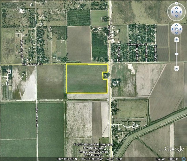

Property Detail
N Intl Blvd
McAllen/Edinburg/Pharr
ADAMS TRACT 35.44 AC - 46.44 AC FT 1052 34.70AC NET
McAllen-Edinburg-Mission, TX
HIDALGO
A0800-00-000-1052-01
Texas
Privatepreserveopenspacevacantlandforestlandconservation
1052
2024
34.70 AC
2025
Outlying Hidalgo County
022504
NEARBY LISTINGS FOR SALE OR LEASE
DEMOGRAPHICS near N Intl Blvd
1 mile
3 mile
5 mile
2025 Total Population
1,886
32,954
98,261
2030 Population
1,974
34,482
103,764
Pop Growth 2025-2030
+ 4.67%
+ 4.64%
+ 5.60%
Average Age
31
33
36
2025 Total Households
468
9,126
29,864
HH Growth 2025-2030
+ 4.70%
+ 4.81%
+ 6.17%
Median Household Inc
$49,499
$48,317
$51,744
Avg Household Size
4.00
3.50
3.20
2025 Avg HH Vehicles
3.00
2.00
2.00
Median Home Value
$127,097
$130,529
$117,175
Median Year Built
2004
2000
1995
Nearby Places
Map Layers
Map Styles
 Street
 Aerial
Layers
 Traffic
 Biking
Places
Listings with unknown addresses are not visible on the map
- Restaurants
- Banks
- Shops
- Fitness
- Groceries
PUBLIC TRANSPORTATION
AIRPORT
McAllen International
Drive
Walk
Distance
McAllen International
29 min
20.6 mi
Valley International
Drive
Walk
Distance
Valley International
34 min
25.0 mi
Freight Ports
Port of Brownsville
Drive
Walk
Distance
Port of Brownsville
52 min
44.3 mi
SALE & LEASE HISTORY
LISTING DATE
SALE/LEASE

Sep 24, 2016
For Sale
Nearby Properties
Address
Land Use
TOTAL SIZE
Lot Size
Zoning
Address
Land Use
TOTAL SIZE
Lot Size
Zoning
255,276 SF
25 AC
Address
Land Use
TOTAL SIZE
Lot Size
Zoning
205,544 SF
20.48 AC
C
Address
Land Use
TOTAL SIZE
Lot Size
Zoning
113,449 SF
19.01 AC
Address
Land Use
TOTAL SIZE
Lot Size
Zoning
108,541 SF
16.50 AC
Address
Land Use
TOTAL SIZE
Lot Size
Zoning
5 SF
46.56 AC
GT
Address
Land Use
TOTAL SIZE
Lot Size
Zoning
79,517 SF
16.26 AC
Address
Land Use
TOTAL SIZE
Lot Size
Zoning
108.55 AC
MP
Address
Land Use
TOTAL SIZE
Lot Size
Zoning
76,552 SF
19.48 AC
CO
Address
Land Use
TOTAL SIZE
Lot Size
Zoning
112,706 SF
10.13 AC
Address
Land Use
TOTAL SIZE
Lot Size
Zoning
135,639 SF
40 AC
Address
Land Use
TOTAL SIZE
Lot Size
Zoning
9 SF
15.24 AC
Address
Land Use
TOTAL SIZE
Lot Size
Zoning
63,469 SF
37.86 AC
CO
Address
Land Use
TOTAL SIZE
Lot Size
Zoning
70,035 SF
16.46 AC
Address
Land Use
TOTAL SIZE
Lot Size
Zoning
94,901 SF
8.80 AC
CO
Address
Land Use
TOTAL SIZE
Lot Size
Zoning
42,589 SF
4.46 AC
Address
Land Use
TOTAL SIZE
Lot Size
Zoning
70,248 SF
7.82 AC
Address
Land Use
TOTAL SIZE
Lot Size
Zoning
106,146 SF
13.25 AC
Address
Land Use
TOTAL SIZE
Lot Size
Zoning
113,200 SF
6.88 AC
IN
Address
Land Use
TOTAL SIZE
Lot Size
Zoning
147,614 SF
9.15 AC
CO
Address
Land Use
TOTAL SIZE
Lot Size
Zoning
352 SF
17.07 AC
GT
Address
Land Use
TOTAL SIZE
Lot Size
Zoning
44,294 SF
5.71 AC
Address
Land Use
TOTAL SIZE
Lot Size
Zoning
73,507 SF
54.69 AC
Address
Land Use
TOTAL SIZE
Lot Size
Zoning
108,876 SF
6.95 AC
Address
Land Use
TOTAL SIZE
Lot Size
Zoning
6 SF
18.27 AC
Address
Land Use
TOTAL SIZE
Lot Size
Zoning
58,335 SF
2.57 AC
CO
Address
Land Use
TOTAL SIZE
Lot Size
Zoning
13 SF
4.89 AC
Address
Land Use
TOTAL SIZE
Lot Size
Zoning
85,844 SF
9.68 AC
Address
Land Use
TOTAL SIZE
Lot Size
Zoning
13,854 SF
4.10 AC
CO
Address
Land Use
TOTAL SIZE
Lot Size
Zoning
3,780 SF
5.56 AC
Address
Land Use
TOTAL SIZE
Lot Size
Zoning
48,303 SF
5.20 AC
The World's #1 Commercial Real Estate Marketplace
Connect with us
© 2026 CoStar Group
The information above has been obtained from sources believed reliable. While we do not doubt its accuracy we have not verified it and make no guarantee, warranty or representation about it. It is your responsibility to independently confirm its accuracy and completeness. Any projections, opinions, assumptions, or estimates used are for example only and do not represent the current or future performance of the property. The value of this transaction to you depends on tax and other factors which should be evaluated by your tax, financial, and legal advisors. You and your advisors should conduct a careful, independent investigation of the property to determine to your satisfaction the suitability of the property for your needs.