Property Record
N Judys Rd, San Tan Valley, AZ 85143
NEARBY LISTINGS FOR SALE OR LEASE
-
-
View all San Tan Valley listings for sale on LoopNet.com
Property Detail
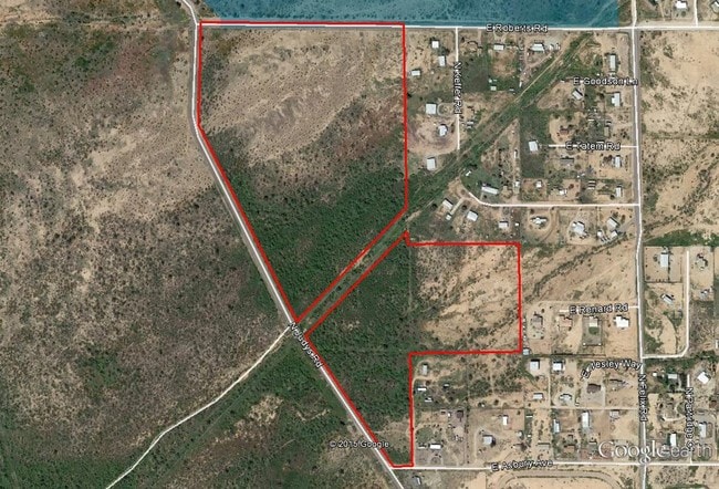
N Judys Rd
Phoenix-Mesa-Scottsdale, AZ
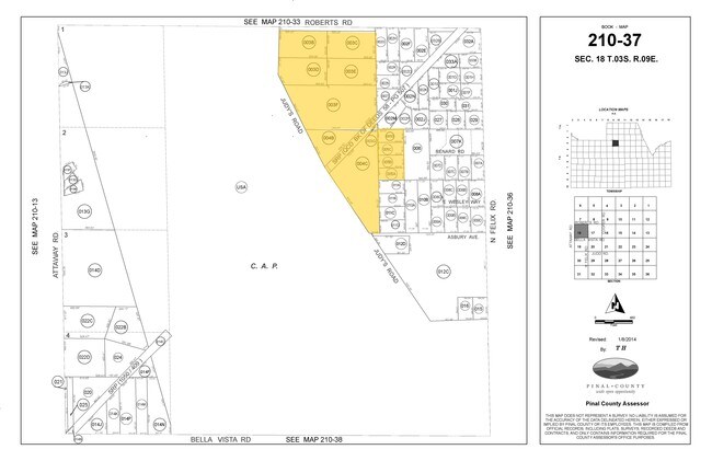
Surveys
210-37-003D
COM @ N4 COR SEC 18-3S-9E TH E-131.09 TH S-400 TO POB TH E-626.98 TH S-353 TH W-564.96 TH N 26 DEG W-147.43 TH N-221.89 TO POB AKA PCL 3 BK 15 OF SURVEYS PG 096 5.01 AC
Vacantlandnec
Pinal
X
Arizona
04021C0500E
5.01 AC
2024
Pinal County
2025
Phoenix
000211
DEMOGRAPHICS near N Judys Rd
1 Mile
3 Mile
5 Mile
2024 Total Population
398
6,591
22,334
2029 Population
496
8,359
28,215
Pop Growth 2024-2029
+ 24.62%
+ 26.82%
+ 26.33%
Average Age
35
34
34
2024 Total Households
116
2,043
6,825
HH Growth 2024-2029
+ 25.00%
+ 26.77%
+ 26.27%
Median Household Inc
$71,052
$73,469
$72,542
Avg Household Size
3.30
3.10
3.20
2024 Avg HH Vehicles
2.00
2.00
2.00
Median Home Value
$353,571
$344,099
$324,812
Median Year Built
2001
2009
2007
Nearby Places
Map Layers
Map Styles
 Street
 Aerial
- Restaurants
- Banks
- Shops
- Fitness
- Groceries
PUBLIC TRANSPORTATION
AIRPORT
Phoenix-Mesa Gateway
DRIVE
WALK
Distance
Phoenix-Mesa Gateway
40 min
18.2 mi
Freight Ports
Port of San Diego
DRIVE
WALK
Distance
Port of San Diego
442 min
385.0 mi
Nearby Properties
Address
Land Use
TOTAL SIZE
Lot Size
Zoning
Address
Land Use
TOTAL SIZE
Lot Size
Zoning
Address
Land Use
TOTAL SIZE
Lot Size
Zoning
Address
Land Use
TOTAL SIZE
Lot Size
Zoning
5,500 SF
0.88 AC
CB1
Address
Land Use
TOTAL SIZE
Lot Size
Zoning
5,732 SF
639.08 AC
UNDESIGNAT
Address
Land Use
TOTAL SIZE
Lot Size
Zoning
5,672 SF
20 AC
GR
Address
Land Use
TOTAL SIZE
Lot Size
Zoning
907 SF
19.09 AC
RVP
Address
Land Use
TOTAL SIZE
Lot Size
Zoning
1,432 SF
0.45 AC
Address
Land Use
TOTAL SIZE
Lot Size
Zoning
Address
Land Use
TOTAL SIZE
Lot Size
Zoning
Address
Land Use
TOTAL SIZE
Lot Size
Zoning
4,224 SF
0.48 AC
Address
Land Use
TOTAL SIZE
Lot Size
Zoning
Address
Land Use
TOTAL SIZE
Lot Size
Zoning
82 SF
13.63 AC
MHP
Address
Land Use
TOTAL SIZE
Lot Size
Zoning
1,980 SF
0.48 AC
Address
Land Use
TOTAL SIZE
Lot Size
Zoning
2,428 SF
0.45 AC
Address
Land Use
TOTAL SIZE
Lot Size
Zoning
3,120 SF
0.45 AC
Address
Land Use
TOTAL SIZE
Lot Size
Zoning
Address
Land Use
TOTAL SIZE
Lot Size
Zoning
Address
Land Use
TOTAL SIZE
Lot Size
Zoning
Address
Land Use
TOTAL SIZE
Lot Size
Zoning
15.91 AC
GR
Address
Land Use
TOTAL SIZE
Lot Size
Zoning
1,318 SF
0.99 AC
Address
Land Use
TOTAL SIZE
Lot Size
Zoning
472.45 AC
UNDESIGNAT
Address
Land Use
TOTAL SIZE
Lot Size
Zoning
320 SF
0.48 AC
Address
Land Use
TOTAL SIZE
Lot Size
Zoning
Address
Land Use
TOTAL SIZE
Lot Size
Zoning
Address
Land Use
TOTAL SIZE
Lot Size
Zoning
Address
Land Use
TOTAL SIZE
Lot Size
Zoning
Address
Land Use
TOTAL SIZE
Lot Size
Zoning
Address
Land Use
TOTAL SIZE
Lot Size
Zoning
Address
Land Use
TOTAL SIZE
Lot Size
Zoning
The World's #1 Commercial Real Estate Marketplace
Connect with us
© 2025 CoStar Group
The information above has been obtained from sources believed reliable. While we do not doubt its accuracy we have not verified it and make no guarantee, warranty or representation about it. It is your responsibility to independently confirm its accuracy and completeness. Any projections, opinions, assumptions, or estimates used are for example only and do not represent the current or future performance of the property. The value of this transaction to you depends on tax and other factors which should be evaluated by your tax, financial, and legal advisors. You and your advisors should conduct a careful, independent investigation of the property to determine to your satisfaction the suitability of the property for your needs.