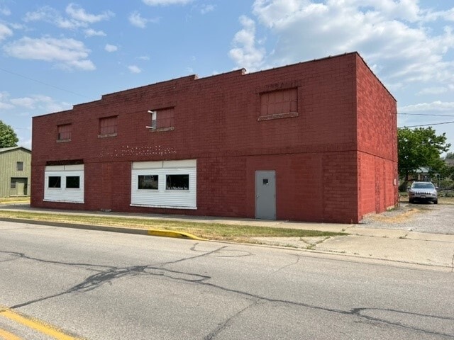
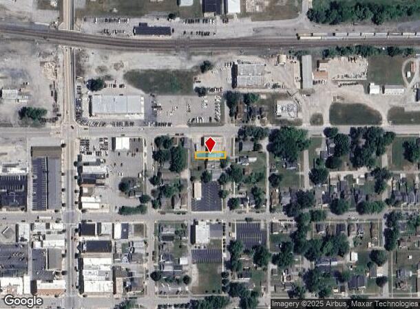
Property Record
N Lee St, Garrett, IN 46738
NEARBY LISTINGS FOR SALE OR LEASE
Property Detail
N Lee St
Auburn, IN
Garrett
17-09-03-106-019.000-013
OP LOT 22 BLOCK 20
Industrialacreage
Dekalb
X
Indiana
18113C0375D
22
2024
0.07 AC
2024
Fort Wayne
020602
Other Market Areas
DEMOGRAPHICS near N Lee St
1 Mile
3 Mile
5 Mile
2024 Total Population
5,909
8,352
20,953
2029 Population
6,061
8,565
21,502
Pop Growth 2024-2029
+ 2.57%
+ 2.55%
+ 2.62%
Average Age
37
38
39
2024 Total Households
2,268
3,211
8,324
HH Growth 2024-2029
+ 2.56%
+ 2.52%
+ 2.64%
Median Household Inc
$52,754
$53,684
$55,140
Avg Household Size
2.50
2.50
2.40
2024 Avg HH Vehicles
2.00
2.00
2.00
Median Home Value
$138,787
$144,427
$145,374
Median Year Built
1956
1963
1972
Nearby Places
Map Layers
Map Styles
 Street
 Aerial
- Restaurants
- Banks
- Shops
- Fitness
- Groceries
PUBLIC TRANSPORTATION
AIRPORT
Fort Wayne International
DRIVE
WALK
Distance
Fort Wayne International
50 min
36.7 mi
Freight Ports
Port of Toledo
DRIVE
WALK
Distance
Port of Toledo
143 min
110.8 mi
SALE & LEASE HISTORY
LISTING DATE
SALE/LEASE

Jul 10, 2023
For Sale
Nearby Properties
Address
Land Use
TOTAL SIZE
Lot Size
Zoning
Address
Land Use
TOTAL SIZE
Lot Size
Zoning
406,797 SF
158.80 AC
Address
Land Use
TOTAL SIZE
Lot Size
Zoning
320,870 SF
106.40 AC
Address
Land Use
TOTAL SIZE
Lot Size
Zoning
180,835 SF
18.82 AC
Address
Land Use
TOTAL SIZE
Lot Size
Zoning
186,496 SF
29.28 AC
Address
Land Use
TOTAL SIZE
Lot Size
Zoning
12,000 SF
159.44 AC
Address
Land Use
TOTAL SIZE
Lot Size
Zoning
15,960 SF
3.09 AC
Address
Land Use
TOTAL SIZE
Lot Size
Zoning
123,126 SF
15 AC
Address
Land Use
TOTAL SIZE
Lot Size
Zoning
18,976 SF
4.13 AC
Address
Land Use
TOTAL SIZE
Lot Size
Zoning
50,876 SF
4.04 AC
Address
Land Use
TOTAL SIZE
Lot Size
Zoning
95,148 SF
14.02 AC
Address
Land Use
TOTAL SIZE
Lot Size
Zoning
20,420 SF
4.70 AC
Address
Land Use
TOTAL SIZE
Lot Size
Zoning
38,708 SF
1.55 AC
Address
Land Use
TOTAL SIZE
Lot Size
Zoning
46,800 SF
1.20 AC
Address
Land Use
TOTAL SIZE
Lot Size
Zoning
58,800 SF
7.33 AC
Address
Land Use
TOTAL SIZE
Lot Size
Zoning
35,407 SF
2.14 AC
Address
Land Use
TOTAL SIZE
Lot Size
Zoning
5,805 SF
8.10 AC
Address
Land Use
TOTAL SIZE
Lot Size
Zoning
39,000 SF
8.49 AC
Address
Land Use
TOTAL SIZE
Lot Size
Zoning
8,040 SF
9.16 AC
Address
Land Use
TOTAL SIZE
Lot Size
Zoning
189,360 SF
21.90 AC
Address
Land Use
TOTAL SIZE
Lot Size
Zoning
25,800 SF
9.02 AC
Address
Land Use
TOTAL SIZE
Lot Size
Zoning
7,200 SF
12 AC
Address
Land Use
TOTAL SIZE
Lot Size
Zoning
85,202 SF
15.30 AC
Address
Land Use
TOTAL SIZE
Lot Size
Zoning
37.04 AC
Address
Land Use
TOTAL SIZE
Lot Size
Zoning
13.25 AC
Address
Land Use
TOTAL SIZE
Lot Size
Zoning
20,560 SF
1.77 AC
Address
Land Use
TOTAL SIZE
Lot Size
Zoning
25,242 SF
6.28 AC
Address
Land Use
TOTAL SIZE
Lot Size
Zoning
6,400 SF
12.79 AC
Address
Land Use
TOTAL SIZE
Lot Size
Zoning
3,348 SF
1.02 AC
Address
Land Use
TOTAL SIZE
Lot Size
Zoning
3,163 SF
1.75 AC
Address
Land Use
TOTAL SIZE
Lot Size
Zoning
5,680 SF
3.35 AC
The World's #1 Commercial Real Estate Marketplace
Connect with us
© 2025 CoStar Group
The information above has been obtained from sources believed reliable. While we do not doubt its accuracy we have not verified it and make no guarantee, warranty or representation about it. It is your responsibility to independently confirm its accuracy and completeness. Any projections, opinions, assumptions, or estimates used are for example only and do not represent the current or future performance of the property. The value of this transaction to you depends on tax and other factors which should be evaluated by your tax, financial, and legal advisors. You and your advisors should conduct a careful, independent investigation of the property to determine to your satisfaction the suitability of the property for your needs.